|
|
|||||||||||||||||
| Point ID: 6711 | Downloads | Plots | Site Data | Code: 10127 |
|
|
|||||||||||||||||
| Download | |
|---|---|
| Site Descriptor Information | Site Time Series Data |
| Link to all available data | |
|

|
| View: | Statistics | Time Series |
| Units: | mm |
| Statistic | Jan | Feb | Mar | Apr | May | Jun | Jul | Aug | Sep | Oct | Nov | Dec | Annual |
|---|---|---|---|---|---|---|---|---|---|---|---|---|---|
| Mean | 20.33 | 15.89 | 20.68 | 111.79 | 322.56 | 269.32 | 122.84 | 91.19 | 74.51 | 74.87 | 41.75 | 25.08 | 98.98 |
| Standard Deviation | 7.57 | 5.97 | 8.45 | 38.99 | 65.51 | 115.87 | 40.74 | 42.84 | 33.07 | 34.85 | 15.10 | 9.58 | 19.66 |
| Min | 8.18 | 3.29 | 11.50 | 49.10 | 157.00 | 103.00 | 54.20 | 33.00 | 32.40 | 33.70 | 17.20 | 9.14 | 62.49 |
| Max | 37.00 | 31.30 | 47.50 | 208.00 | 434.00 | 509.00 | 194.00 | 220.00 | 174.00 | 160.00 | 73.40 | 49.20 | 132.14 |
| Coefficient of Variation | 0.37 | 0.38 | 0.41 | 0.35 | 0.20 | 0.43 | 0.33 | 0.47 | 0.44 | 0.47 | 0.36 | 0.38 | 0.20 |
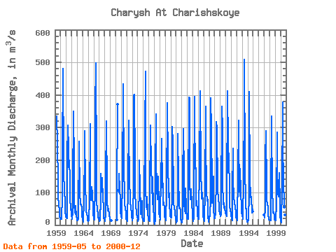
| Year | Jan | Feb | Mar | Apr | May | Jun | Jul | Aug | Sep | Oct | Nov | Dec | Annual | 1959 | 335.00 | 249.00 | 132.00 | 89.80 | 58.80 | 49.10 | 29.30 | 18.10 | 1960 | 18.20 | 17.70 | 17.50 | 87.30 | 210.00 | 480.00 | 185.00 | 162.00 | 105.00 | 72.00 | 42.80 | 24.70 | 118.52 | 1961 | 29.70 | 22.00 | 21.50 | 208.00 | 307.00 | 235.00 | 178.00 | 198.00 | 140.00 | 85.50 | 47.00 | 49.20 | 126.74 | 1962 | 31.70 | 18.20 | 42.70 | 119.00 | 349.00 | 188.00 | 61.30 | 39.60 | 32.40 | 58.50 | 26.10 | 19.20 | 82.14 | 1963 | 14.60 | 14.60 | 20.80 | 49.10 | 224.00 | 257.00 | 93.10 | 69.90 | 64.00 | 63.40 | 49.90 | 27.00 | 78.95 | 1964 | 17.80 | 10.50 | 16.00 | 70.60 | 236.00 | 289.00 | 113.00 | 68.90 | 41.30 | 34.80 | 24.70 | 14.70 | 78.11 | 1965 | 12.80 | 14.00 | 18.40 | 74.60 | 311.00 | 140.00 | 75.80 | 82.90 | 117.00 | 96.70 | 48.80 | 28.90 | 85.08 | 1966 | 25.40 | 19.20 | 17.10 | 129.00 | 353.00 | 497.00 | 178.00 | 71.60 | 45.60 | 35.10 | 22.60 | 23.20 | 118.07 | 1967 | 11.60 | 11.80 | 14.10 | 80.90 | 157.00 | 103.00 | 122.00 | 145.00 | 77.20 | 58.80 | 21.40 | 19.70 | 68.54 | 1968 | 16.60 | 12.80 | 33.30 | 136.00 | 320.00 | 107.00 | 77.00 | 44.20 | 51.20 | 50.20 | 30.40 | 18.90 | 74.80 | 1969 | 15.90 | 14.00 | 14.20 | 1970 | 15.80 | 97.00 | 370.00 | 107.00 | 99.20 | 157.00 | 112.00 | 73.40 | 40.90 | 1971 | 23.80 | 20.30 | 25.50 | 136.00 | 434.00 | 428.00 | 167.00 | 98.70 | 64.30 | 49.60 | 37.40 | 18.20 | 125.23 | 1972 | 15.20 | 13.50 | 12.00 | 115.00 | 322.00 | 265.00 | 155.00 | 64.40 | 70.10 | 52.90 | 38.70 | 26.40 | 95.85 | 1973 | 14.30 | 13.50 | 23.20 | 138.00 | 396.00 | 402.00 | 192.00 | 106.00 | 50.30 | 48.40 | 35.30 | 22.90 | 120.16 | 1974 | 18.50 | 12.60 | 15.60 | 128.00 | 200.00 | 110.00 | 54.20 | 33.00 | 64.70 | 73.30 | 24.50 | 15.50 | 62.49 | 1975 | 12.60 | 10.80 | 11.50 | 70.50 | 293.00 | 471.00 | 115.00 | 58.50 | 48.90 | 88.00 | 39.60 | 15.60 | 102.92 | 1976 | 16.50 | 13.30 | 12.90 | 87.90 | 306.00 | 177.00 | 168.00 | 130.00 | 63.10 | 148.00 | 47.90 | 26.60 | 99.77 | 1977 | 11.20 | 3.29 | 16.90 | 157.00 | 341.00 | 222.00 | 95.90 | 129.00 | 78.90 | 150.00 | 58.00 | 32.40 | 107.97 | 1978 | 28.10 | 16.40 | 20.80 | 153.00 | 226.00 | 266.00 | 115.00 | 128.00 | 61.00 | 69.90 | 49.60 | 26.30 | 96.67 | 1979 | 19.40 | 18.80 | 13.10 | 100.00 | 372.00 | 376.00 | 194.00 | 92.30 | 83.90 | 98.50 | 71.10 | 27.70 | 122.23 | 1980 | 24.00 | 23.20 | 22.50 | 99.50 | 303.00 | 252.00 | 107.00 | 70.70 | 49.60 | 43.90 | 36.00 | 18.80 | 87.52 | 1981 | 10.90 | 7.12 | 13.40 | 101.00 | 281.00 | 139.00 | 64.60 | 51.30 | 51.90 | 44.80 | 21.10 | 10.50 | 66.39 | 1982 | 8.18 | 8.86 | 23.00 | 133.00 | 295.00 | 160.00 | 64.30 | 45.80 | 36.30 | 112.00 | 49.50 | 23.40 | 79.94 | 1983 | 20.80 | 18.60 | 19.10 | 69.90 | 393.00 | 388.00 | 136.00 | 78.10 | 104.00 | 111.00 | 65.60 | 37.20 | 120.11 | 1984 | 25.70 | 10.90 | 22.10 | 102.00 | 394.00 | 329.00 | 174.00 | 176.00 | 59.70 | 75.00 | 39.20 | 32.60 | 120.02 | 1985 | 18.80 | 18.70 | 21.20 | 194.00 | 381.00 | 412.00 | 162.00 | 104.00 | 79.80 | 99.60 | 67.50 | 27.10 | 132.14 | 1986 | 18.10 | 11.80 | 18.20 | 100.00 | 365.00 | 268.00 | 97.60 | 76.90 | 73.70 | 78.40 | 26.90 | 10.30 | 95.41 | 1987 | 22.80 | 26.80 | 26.40 | 82.00 | 391.00 | 292.00 | 117.00 | 68.00 | 111.00 | 150.00 | 53.10 | 19.80 | 113.33 | 1988 | 24.20 | 21.30 | 38.50 | 146.00 | 318.00 | 296.00 | 115.00 | 107.00 | 83.00 | 59.50 | 46.90 | 34.00 | 107.45 | 1989 | 37.00 | 27.50 | 31.70 | 59.70 | 364.00 | 292.00 | 129.00 | 69.10 | 53.70 | 68.70 | 48.80 | 41.40 | 101.88 | 1990 | 35.00 | 31.30 | 25.90 | 89.80 | 412.00 | 249.00 | 161.00 | 220.00 | 95.90 | 58.30 | 43.70 | 35.00 | 121.41 | 1991 | 32.50 | 17.70 | 14.30 | 95.10 | 236.00 | 149.00 | 78.90 | 74.80 | 62.40 | 58.50 | 34.50 | 22.80 | 73.04 | 1992 | 24.60 | 13.10 | 26.30 | 143.00 | 321.00 | 262.00 | 112.00 | 89.30 | 174.00 | 101.00 | 54.50 | 39.00 | 113.32 | 1993 | 29.90 | 20.70 | 19.10 | 146.00 | 368.00 | 509.00 | 177.00 | 71.30 | 51.20 | 49.90 | 24.20 | 9.14 | 122.95 | 1994 | 9.64 | 9.46 | 14.00 | 100.00 | 409.00 | 146.00 | 85.40 | 89.20 | 86.60 | 37.10 | 57.10 | 41.00 | 90.38 | 1997 | 31.10 | 23.00 | 47.50 | 204.00 | 289.00 | 116.00 | 76.50 | 65.60 | 54.40 | 33.70 | 17.20 | 15.20 | 81.10 | 1998 | 15.80 | 14.10 | 13.20 | 71.60 | 334.00 | 297.00 | 115.00 | 45.80 | 37.00 | 39.30 | 29.60 | 15.10 | 85.62 | 1999 | 15.10 | 15.00 | 13.60 | 65.40 | 286.00 | 179.00 | 97.10 | 87.30 | 119.00 | 160.00 | 64.00 | 28.10 | 94.13 | 2000 | 14.40 | 7.49 | 13.80 | 109.00 | 378.00 | 237.00 | 143.00 | 55.40 | 48.10 | 44.70 | 30.20 | 21.50 | 91.88 |
|---|
 Return to R-Arctic Net Home Page
