|
|
|||||||||||||||||
| Point ID: 6669 | Downloads | Plots | Site Data | Code: 10044 |
|
|
|||||||||||||||||
| Download | |
|---|---|
| Site Descriptor Information | Site Time Series Data |
| Link to all available data | |

|
|
| View: | Statistics | Time Series |
| Units: | mm |
| Statistic | Jan | Feb | Mar | Apr | May | Jun | Jul | Aug | Sep | Oct | Nov | Dec | Annual |
|---|---|---|---|---|---|---|---|---|---|---|---|---|---|
| Mean | 51.59 | 41.67 | 39.14 | 218.64 | 658.18 | 924.32 | 599.38 | 474.35 | 348.38 | 261.35 | 159.00 | 89.43 | 323.83 |
| Standard Deviation | 14.29 | 9.74 | 15.03 | 64.41 | 157.34 | 335.52 | 198.28 | 227.45 | 99.03 | 75.43 | 34.28 | 25.74 | 62.89 |
| Min | 26.40 | 22.20 | 18.30 | 116.00 | 393.00 | 515.00 | 300.00 | 187.00 | 194.00 | 152.00 | 95.70 | 46.20 | 207.70 |
| Max | 82.10 | 69.30 | 76.00 | 357.00 | 1210.00 | 1940.00 | 1240.00 | 1100.00 | 527.00 | 486.00 | 240.00 | 150.00 | 470.22 |
| Coefficient of Variation | 0.28 | 0.23 | 0.38 | 0.29 | 0.24 | 0.36 | 0.33 | 0.48 | 0.28 | 0.29 | 0.22 | 0.29 | 0.19 |
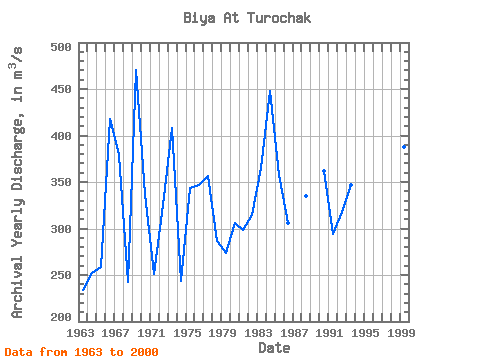
| Year | Jan | Feb | Mar | Apr | May | Jun | Jul | Aug | Sep | Oct | Nov | Dec | Annual | 1962 | 708.00 | 786.00 | 432.00 | 270.00 | 202.00 | 190.00 | 1963 | 56.80 | 31.40 | 50.30 | 116.00 | 413.00 | 925.00 | 437.00 | 215.00 | 194.00 | 152.00 | 122.00 | 89.30 | 233.48 | 1964 | 38.50 | 22.20 | 23.30 | 124.00 | 465.00 | 894.00 | 584.00 | 335.00 | 221.00 | 152.00 | 99.30 | 69.40 | 252.31 | 1965 | 46.00 | 33.50 | 28.10 | 155.00 | 765.00 | 552.00 | 345.00 | 253.00 | 402.00 | 263.00 | 161.00 | 100.00 | 258.63 | 1966 | 53.80 | 46.00 | 65.30 | 273.00 | 746.00 | 1940.00 | 808.00 | 468.00 | 250.00 | 176.00 | 129.00 | 58.50 | 417.80 | 1967 | 36.00 | 41.30 | 25.20 | 219.00 | 474.00 | 819.00 | 780.00 | 1100.00 | 527.00 | 299.00 | 151.00 | 80.70 | 379.35 | 1968 | 51.00 | 38.80 | 34.40 | 163.00 | 825.00 | 573.00 | 300.00 | 248.00 | 280.00 | 206.00 | 126.00 | 64.70 | 242.49 | 1969 | 32.60 | 34.50 | 33.30 | 301.00 | 1210.00 | 1570.00 | 738.00 | 487.00 | 514.00 | 427.00 | 206.00 | 89.20 | 470.22 | 1970 | 43.60 | 39.50 | 34.40 | 261.00 | 748.00 | 907.00 | 570.00 | 468.00 | 429.00 | 306.00 | 185.00 | 49.50 | 336.75 | 1971 | 42.70 | 41.90 | 29.00 | 220.00 | 574.00 | 680.00 | 560.00 | 291.00 | 217.00 | 173.00 | 116.00 | 69.60 | 251.18 | 1972 | 28.50 | 27.10 | 20.00 | 256.00 | 678.00 | 833.00 | 654.00 | 436.00 | 396.00 | 304.00 | 174.00 | 99.90 | 325.54 | 1973 | 46.10 | 43.20 | 32.20 | 267.00 | 621.00 | 1560.00 | 913.00 | 505.00 | 390.00 | 262.00 | 151.00 | 109.00 | 408.29 | 1974 | 26.40 | 40.50 | 27.40 | 246.00 | 552.00 | 708.00 | 324.00 | 187.00 | 246.00 | 313.00 | 155.00 | 92.10 | 243.12 | 1975 | 43.70 | 42.10 | 26.70 | 137.00 | 502.00 | 1630.00 | 733.00 | 352.00 | 249.00 | 234.00 | 117.00 | 59.00 | 343.79 | 1976 | 39.20 | 33.90 | 30.20 | 182.00 | 801.00 | 907.00 | 632.00 | 693.00 | 322.00 | 330.00 | 139.00 | 49.70 | 346.58 | 1977 | 50.80 | 37.80 | 52.00 | 343.00 | 654.00 | 935.00 | 538.00 | 505.00 | 466.00 | 362.00 | 198.00 | 140.00 | 356.80 | 1978 | 61.70 | 44.20 | 27.90 | 357.00 | 551.00 | 767.00 | 439.00 | 513.00 | 294.00 | 192.00 | 121.00 | 72.60 | 286.70 | 1979 | 42.40 | 33.00 | 18.30 | 141.00 | 606.00 | 697.00 | 375.00 | 304.00 | 476.00 | 292.00 | 211.00 | 87.70 | 273.62 | 1980 | 37.70 | 32.80 | 21.40 | 158.00 | 738.00 | 833.00 | 657.00 | 400.00 | 306.00 | 214.00 | 172.00 | 95.80 | 305.48 | 1981 | 69.50 | 43.00 | 45.50 | 307.00 | 723.00 | 592.00 | 347.00 | 406.00 | 467.00 | 287.00 | 184.00 | 114.00 | 298.75 | 1982 | 61.60 | 42.80 | 44.80 | 261.00 | 759.00 | 839.00 | 468.00 | 463.00 | 267.00 | 265.00 | 188.00 | 115.00 | 314.52 | 1983 | 59.20 | 38.20 | 48.30 | 146.00 | 604.00 | 993.00 | 709.00 | 627.00 | 436.00 | 353.00 | 212.00 | 150.00 | 364.64 | 1984 | 60.10 | 36.50 | 33.50 | 146.00 | 576.00 | 1200.00 | 1240.00 | 1070.00 | 385.00 | 305.00 | 199.00 | 121.00 | 447.68 | 1985 | 82.10 | 69.30 | 60.50 | 213.00 | 569.00 | 1070.00 | 754.00 | 566.00 | 431.00 | 251.00 | 147.00 | 81.10 | 357.83 | 1986 | 52.60 | 39.90 | 27.30 | 137.00 | 683.00 | 722.00 | 600.00 | 472.00 | 386.00 | 290.00 | 156.00 | 103.00 | 305.73 | 1988 | 59.60 | 39.90 | 37.50 | 212.00 | 596.00 | 880.00 | 784.00 | 789.00 | 292.00 | 179.00 | 95.70 | 53.20 | 334.82 | 1990 | 56.00 | 47.80 | 60.30 | 205.00 | 560.00 | 789.00 | 629.00 | 938.00 | 503.00 | 266.00 | 172.00 | 115.00 | 361.76 | 1991 | 73.70 | 43.30 | 40.90 | 223.00 | 607.00 | 605.00 | 623.00 | 479.00 | 324.00 | 237.00 | 164.00 | 107.00 | 293.91 | 1992 | 77.70 | 50.00 | 28.40 | 267.00 | 734.00 | 892.00 | 429.00 | 354.00 | 448.00 | 267.00 | 154.00 | 106.00 | 317.26 | 1993 | 73.40 | 56.20 | 57.70 | 269.00 | 493.00 | 1360.00 | 701.00 | 416.00 | 297.00 | 215.00 | 137.00 | 81.50 | 346.40 | 1994 | 54.10 | 46.00 | 40.30 | 234.00 | 733.00 | 593.00 | 377.00 | 293.00 | 364.00 | 197.00 | 166.00 | 98.30 | 266.31 | 1998 | 37.30 | 36.50 | 44.40 | 175.00 | 393.00 | 515.00 | 442.00 | 255.00 | 207.00 | 187.00 | 154.00 | 46.20 | 207.70 | 1999 | 41.30 | 57.30 | 76.00 | 222.00 | 867.00 | 831.00 | 699.00 | 664.00 | 365.00 | 486.00 | 240.00 | 106.00 | 387.88 | 2000 | 66.80 | 64.70 | 66.70 | 279.00 | 850.00 | 1030.00 | 758.00 | 306.00 | 292.00 | 254.00 | 145.00 | 77.10 | 349.11 |
|---|
 Return to R-Arctic Net Home Page
