|
|
|||||||||||||||||
| Point ID: 6620 | Downloads | Plots | Site Data | Code: 9401 |
|
|
|||||||||||||||||
| Download | |
|---|---|
| Site Descriptor Information | Site Time Series Data |
| Link to all available data | |
|
|
| View: | Statistics | Time Series |
| Units: | mm |
| Statistic | Jan | Feb | Mar | Apr | May | Jun | Jul | Aug | Sep | Oct | Nov | Dec | Annual |
|---|---|---|---|---|---|---|---|---|---|---|---|---|---|
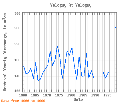
| Mean | 57.60 | 53.76 | 52.59 | 70.62 | 550.21 | 476.13 | 151.48 | 150.25 | 150.76 | 127.44 | 83.60 | 68.11 | 166.05 |
| Standard Deviation | 11.81 | 11.37 | 12.50 | 57.21 | 170.71 | 228.38 | 70.44 | 143.64 | 67.36 | 50.20 | 20.03 | 16.77 | 30.49 |
| Min | 36.50 | 27.10 | 27.80 | 33.60 | 88.60 | 162.00 | 69.30 | 67.20 | 63.70 | 55.30 | 51.50 | 43.30 | 127.83 |
| Max | 95.30 | 90.00 | 92.50 | 372.00 | 971.00 | 1280.00 | 394.00 | 930.00 | 313.00 | 245.00 | 124.00 | 136.00 | 261.81 |
| Coefficient of Variation | 0.20 | 0.21 | 0.24 | 0.81 | 0.31 | 0.48 | 0.47 | 0.96 | 0.45 | 0.39 | 0.24 | 0.25 | 0.18 |
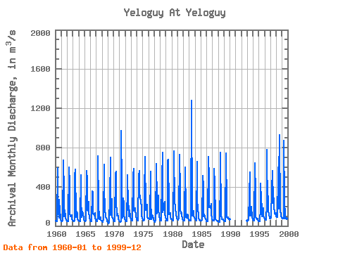
| Year | Jan | Feb | Mar | Apr | May | Jun | Jul | Aug | Sep | Oct | Nov | Dec | Annual | 1960 | 52.10 | 50.80 | 48.10 | 48.60 | 594.00 | 396.00 | 138.00 | 83.70 | 269.00 | 139.00 | 95.40 | 67.80 | 165.21 | 1961 | 47.60 | 48.30 | 48.40 | 56.20 | 671.00 | 349.00 | 94.10 | 160.00 | 87.30 | 72.20 | 57.70 | 51.00 | 145.23 | 1962 | 46.80 | 45.40 | 45.00 | 48.20 | 595.00 | 429.00 | 130.00 | 99.70 | 110.00 | 110.00 | 67.80 | 57.20 | 148.68 | 1963 | 52.60 | 51.70 | 49.60 | 50.70 | 508.00 | 579.00 | 91.40 | 125.00 | 150.00 | 125.00 | 72.20 | 57.10 | 159.36 | 1964 | 51.80 | 49.70 | 46.50 | 46.60 | 521.00 | 276.00 | 92.80 | 101.00 | 150.00 | 121.00 | 80.10 | 60.80 | 133.11 | 1965 | 55.10 | 49.30 | 47.80 | 52.80 | 563.00 | 470.00 | 161.00 | 151.00 | 247.00 | 141.00 | 83.40 | 58.70 | 173.34 | 1966 | 53.80 | 48.30 | 47.40 | 50.00 | 357.00 | 346.00 | 129.00 | 124.00 | 104.00 | 135.00 | 80.00 | 59.40 | 127.83 | 1967 | 52.20 | 48.50 | 46.50 | 90.30 | 710.00 | 212.00 | 88.20 | 67.20 | 76.70 | 92.10 | 58.50 | 52.40 | 132.88 | 1968 | 46.50 | 41.10 | 40.50 | 75.70 | 626.00 | 391.00 | 171.00 | 104.00 | 89.90 | 83.00 | 63.50 | 43.30 | 147.96 | 1969 | 36.50 | 27.10 | 27.80 | 33.60 | 291.00 | 701.00 | 111.00 | 148.00 | 275.00 | 96.50 | 78.30 | 64.60 | 157.53 | 1970 | 53.50 | 47.20 | 48.30 | 49.40 | 535.00 | 556.00 | 272.00 | 103.00 | 123.00 | 81.80 | 71.00 | 55.80 | 166.33 | 1971 | 48.90 | 46.70 | 43.00 | 46.60 | 971.00 | 383.00 | 115.00 | 85.40 | 285.00 | 224.00 | 101.00 | 75.90 | 202.12 | 1972 | 51.30 | 48.50 | 45.20 | 48.10 | 430.00 | 520.00 | 211.00 | 97.20 | 201.00 | 124.00 | 124.00 | 94.20 | 166.21 | 1973 | 62.00 | 54.50 | 51.30 | 55.20 | 520.00 | 581.00 | 153.00 | 164.00 | 183.00 | 177.00 | 87.50 | 79.80 | 180.69 | 1974 | 67.60 | 57.30 | 52.40 | 60.40 | 516.00 | 564.00 | 350.00 | 284.00 | 252.00 | 191.00 | 113.00 | 75.30 | 215.25 | 1975 | 60.80 | 57.00 | 54.50 | 57.80 | 342.00 | 704.00 | 160.00 | 220.00 | 190.00 | 217.00 | 95.60 | 76.00 | 186.22 | 1976 | 74.40 | 68.70 | 67.10 | 67.40 | 552.00 | 279.00 | 69.30 | 82.20 | 114.00 | 101.00 | 68.80 | 58.50 | 133.53 | 1977 | 49.80 | 43.30 | 42.80 | 60.20 | 633.00 | 267.00 | 122.00 | 141.00 | 313.00 | 164.00 | 102.00 | 62.40 | 166.71 | 1978 | 53.20 | 56.60 | 56.00 | 52.70 | 484.00 | 746.00 | 137.00 | 176.00 | 218.00 | 245.00 | 121.00 | 87.60 | 202.76 | 1979 | 66.60 | 55.30 | 50.80 | 52.80 | 669.00 | 675.00 | 200.00 | 117.00 | 121.00 | 133.00 | 89.80 | 70.80 | 191.76 | 1980 | 66.60 | 58.20 | 55.80 | 57.10 | 637.00 | 765.00 | 228.00 | 211.00 | 188.00 | 110.00 | 83.90 | 75.50 | 211.34 | 1981 | 70.90 | 65.00 | 57.60 | 79.80 | 730.00 | 351.00 | 176.00 | 123.00 | 131.00 | 109.00 | 65.60 | 64.50 | 168.62 | 1982 | 53.30 | 53.40 | 50.80 | 107.00 | 601.00 | 162.00 | 90.00 | 85.40 | 119.00 | 102.00 | 76.80 | 63.70 | 130.37 | 1983 | 57.40 | 55.90 | 53.40 | 52.30 | 88.60 | 1280.00 | 113.00 | 103.00 | 140.00 | 156.00 | 95.00 | 81.10 | 189.64 | 1984 | 65.00 | 61.10 | 58.80 | 54.10 | 656.00 | 258.00 | 191.00 | 94.60 | 81.10 | 64.20 | 58.20 | 55.90 | 141.50 | 1985 | 52.80 | 51.10 | 50.70 | 57.50 | 509.00 | 401.00 | 94.80 | 116.00 | 93.60 | 91.40 | 68.30 | 53.30 | 136.62 | 1986 | 46.00 | 45.10 | 43.20 | 44.70 | 705.00 | 486.00 | 192.00 | 203.00 | 181.00 | 224.00 | 123.00 | 77.70 | 197.56 | 1987 | 55.60 | 52.30 | 52.30 | 53.60 | 581.00 | 427.00 | 105.00 | 70.90 | 63.70 | 55.30 | 51.50 | 48.80 | 134.75 | 1988 | 43.90 | 42.40 | 41.20 | 41.10 | 476.00 | 750.00 | 111.00 | 68.70 | 71.20 | 70.50 | 65.30 | 58.80 | 153.34 | 1989 | 52.90 | 48.30 | 46.70 | 49.90 | 742.00 | 203.00 | 92.50 | 81.20 | 91.10 | 78.20 | 78.70 | 65.80 | 135.86 | 1993 | 55.50 | 52.60 | 54.40 | 58.00 | 318.00 | 547.00 | 107.00 | 105.00 | 132.00 | 194.00 | 85.50 | 71.20 | 148.35 | 1994 | 58.90 | 55.20 | 54.60 | 55.60 | 642.00 | 330.00 | 97.80 | 72.40 | 71.50 | 74.70 | 57.80 | 49.00 | 134.96 | 1995 | 45.80 | 45.50 | 47.40 | 185.00 | 436.00 | 271.00 | 181.00 | 94.80 | 108.00 | 180.00 | 104.00 | 85.50 | 148.67 | 1996 | 69.20 | 61.30 | 58.10 | 58.50 | 217.00 | 778.00 | 145.00 | 306.00 | 152.00 | 116.00 | 73.30 | 79.10 | 176.12 | 1997 | 76.30 | 79.10 | 91.50 | 372.00 | 563.00 | 236.00 | 394.00 | 177.00 | 146.00 | 128.00 | 118.00 | 136.00 | 209.74 | 1998 | 95.30 | 90.00 | 92.50 | 105.00 | 495.00 | 707.00 | 176.00 | 930.00 | 149.00 | 118.00 | 101.00 | 82.90 | 261.81 | 1999 | 82.90 | 77.30 | 77.80 | 78.50 | 873.00 | 241.00 | 115.00 | 83.90 | 101.00 | 71.40 | 76.60 | 62.60 | 161.75 |
|---|
 Return to R-Arctic Net Home Page
