|
|
|||||||||||||||||
| Point ID: 6613 | Downloads | Plots | Site Data | Code: 9388 |
|
|
|||||||||||||||||
| Download | |
|---|---|
| Site Descriptor Information | Site Time Series Data |
| Link to all available data | |

|
|
| View: | Statistics | Time Series |
| Units: | mm |
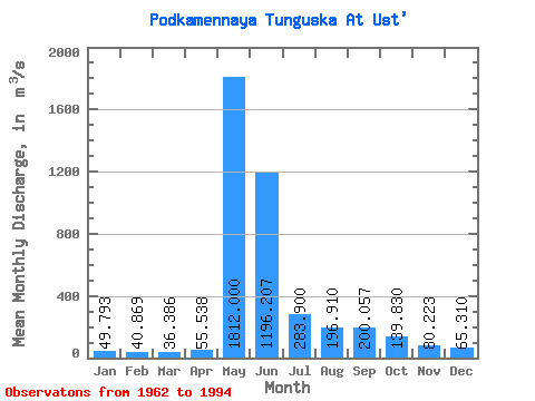
| Statistic | Jan | Feb | Mar | Apr | May | Jun | Jul | Aug | Sep | Oct | Nov | Dec | Annual |
|---|---|---|---|---|---|---|---|---|---|---|---|---|---|
| Mean | 49.79 | 40.87 | 36.39 | 55.54 | 1812.00 | 1196.21 | 283.90 | 196.91 | 200.06 | 139.83 | 80.22 | 65.31 | 346.83 |
| Standard Deviation | 24.21 | 18.59 | 16.59 | 49.07 | 549.89 | 642.68 | 130.85 | 98.35 | 97.75 | 80.31 | 37.31 | 31.03 | 82.68 |
| Min | 17.90 | 17.30 | 12.20 | 10.40 | 25.00 | 364.00 | 127.00 | 77.60 | 85.70 | 45.60 | 29.50 | 25.50 | 213.63 |
| Max | 127.00 | 98.80 | 82.00 | 250.00 | 2540.00 | 3730.00 | 633.00 | 440.00 | 460.00 | 401.00 | 169.00 | 159.00 | 583.92 |
| Coefficient of Variation | 0.49 | 0.46 | 0.46 | 0.88 | 0.30 | 0.54 | 0.46 | 0.50 | 0.49 | 0.57 | 0.47 | 0.47 | 0.24 |
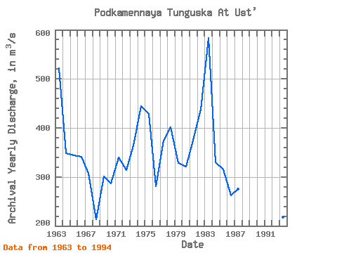
| Year | Jan | Feb | Mar | Apr | May | Jun | Jul | Aug | Sep | Oct | Nov | Dec | Annual | 1962 | 261.00 | 162.00 | 164.00 | 119.00 | 60.30 | 57.20 | 1963 | 51.30 | 45.40 | 48.80 | 51.50 | 1870.00 | 2020.00 | 564.00 | 423.00 | 460.00 | 401.00 | 169.00 | 159.00 | 521.92 | 1964 | 127.00 | 98.80 | 82.00 | 71.20 | 2030.00 | 935.00 | 368.00 | 157.00 | 128.00 | 79.30 | 59.50 | 53.30 | 349.09 | 1965 | 38.00 | 33.70 | 33.10 | 33.00 | 1740.00 | 975.00 | 233.00 | 168.00 | 375.00 | 263.00 | 137.00 | 97.30 | 343.84 | 1966 | 73.20 | 59.30 | 57.40 | 48.60 | 2320.00 | 849.00 | 259.00 | 119.00 | 119.00 | 91.20 | 52.90 | 44.20 | 341.07 | 1967 | 37.80 | 32.30 | 34.00 | 250.00 | 1940.00 | 498.00 | 186.00 | 183.00 | 209.00 | 170.00 | 73.40 | 62.80 | 306.36 | 1968 | 52.60 | 38.00 | 33.40 | 58.90 | 1340.00 | 434.00 | 177.00 | 100.00 | 138.00 | 113.00 | 53.20 | 25.50 | 213.63 | 1969 | 17.90 | 17.30 | 15.70 | 17.30 | 1330.00 | 1670.00 | 252.00 | 81.60 | 101.00 | 45.60 | 34.40 | 35.00 | 301.48 | 1970 | 26.30 | 26.00 | 24.20 | 29.80 | 1510.00 | 913.00 | 321.00 | 267.00 | 149.00 | 77.60 | 60.00 | 43.80 | 287.31 | 1971 | 28.30 | 19.90 | 26.30 | 44.80 | 1980.00 | 643.00 | 269.00 | 225.00 | 341.00 | 260.00 | 135.00 | 98.10 | 339.20 | 1972 | 68.80 | 49.70 | 37.60 | 51.30 | 1600.00 | 1090.00 | 230.00 | 203.00 | 226.00 | 116.00 | 58.30 | 45.40 | 314.68 | 1973 | 40.20 | 37.80 | 36.30 | 35.10 | 1850.00 | 1350.00 | 457.00 | 292.00 | 117.00 | 54.50 | 49.20 | 46.40 | 363.79 | 1974 | 42.90 | 38.20 | 29.30 | 32.10 | 1530.00 | 2080.00 | 376.00 | 311.00 | 418.00 | 239.00 | 137.00 | 95.00 | 444.04 | 1975 | 68.10 | 59.50 | 56.60 | 68.40 | 2510.00 | 1130.00 | 280.00 | 241.00 | 261.00 | 274.00 | 110.00 | 87.00 | 428.80 | 1976 | 64.70 | 53.60 | 46.30 | 49.90 | 1700.00 | 903.00 | 127.00 | 117.00 | 139.00 | 80.90 | 45.30 | 42.40 | 280.76 | 1977 | 35.90 | 25.70 | 24.30 | 47.10 | 2170.00 | 1420.00 | 185.00 | 125.00 | 194.00 | 108.00 | 89.60 | 71.20 | 374.65 | 1978 | 54.20 | 47.90 | 43.80 | 49.20 | 2540.00 | 1170.00 | 191.00 | 192.00 | 222.00 | 158.00 | 77.00 | 78.40 | 401.96 | 1979 | 69.60 | 47.00 | 12.20 | 10.40 | 2210.00 | 1190.00 | 128.00 | 77.60 | 85.70 | 55.40 | 29.50 | 28.60 | 328.67 | 1980 | 27.80 | 23.10 | 21.20 | 23.80 | 1650.00 | 1450.00 | 150.00 | 198.00 | 127.00 | 105.00 | 45.30 | 31.20 | 321.03 | 1981 | 29.10 | 30.00 | 28.60 | 191.00 | 2340.00 | 364.00 | 633.00 | 333.00 | 243.00 | 121.00 | 96.70 | 77.80 | 373.93 | 1982 | 51.00 | 39.50 | 32.30 | 61.10 | 2500.00 | 1100.00 | 459.00 | 440.00 | 223.00 | 108.00 | 128.00 | 113.00 | 437.91 | 1983 | 92.40 | 81.20 | 76.40 | 70.50 | 1830.00 | 3730.00 | 458.00 | 181.00 | 185.00 | 138.00 | 76.50 | 88.10 | 583.92 | 1984 | 64.50 | 41.10 | 42.80 | 43.90 | 2330.00 | 877.00 | 196.00 | 113.00 | 103.00 | 63.60 | 47.90 | 38.50 | 330.11 | 1985 | 36.70 | 31.80 | 26.00 | 28.50 | 1870.00 | 1130.00 | 214.00 | 85.10 | 166.00 | 104.00 | 50.50 | 37.70 | 315.02 | 1986 | 21.80 | 20.30 | 21.30 | 26.50 | 1540.00 | 815.00 | 133.00 | 170.00 | 188.00 | 110.00 | 55.60 | 39.00 | 261.71 | 1987 | 27.60 | 25.00 | 24.70 | 25.40 | 1300.00 | 1030.00 | 423.00 | 164.00 | 109.00 | 90.80 | 46.90 | 35.60 | 275.17 | 1988 | 28.40 | 23.70 | 23.50 | 33.00 | 1670.00 | 1190.00 | 324.00 | 364.00 | 303.00 | 162.00 | 136.00 | 107.00 | 363.72 | 1989 | 81.10 | 64.30 | 54.70 | 52.70 | 2520.00 | 884.00 | 234.00 | 188.00 | 252.00 | 201.00 | 116.00 | 82.10 | 394.16 | 1993 | 42.60 | 38.80 | 29.20 | 67.60 | 803.00 | 1010.00 | 161.00 | 106.00 | 90.00 | 101.00 | 90.10 | 72.30 | 217.63 | 1994 | 44.20 | 36.30 | 33.20 | 38.00 | 25.00 | 1840.00 | 268.00 | 121.00 | 166.00 | 185.00 | 86.60 | 66.40 | 242.47 |
|---|
 Return to R-Arctic Net Home Page