|
|
|||||||||||||||||
| Point ID: 6556 | Downloads | Plots | Site Data | Code: 9130 |
|
|
|||||||||||||||||
| Download | |
|---|---|
| Site Descriptor Information | Site Time Series Data |
| Link to all available data | |
|
|
| View: | Statistics | Time Series |
| Units: | mm |
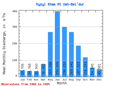
| Statistic | Jan | Feb | Mar | Apr | May | Jun | Jul | Aug | Sep | Oct | Nov | Dec | Annual |
|---|---|---|---|---|---|---|---|---|---|---|---|---|---|
| Mean | 39.70 | 34.77 | 33.90 | 76.06 | 269.29 | 393.00 | 298.25 | 269.04 | 187.52 | 116.24 | 54.84 | 45.58 | 148.41 |
| Standard Deviation | 7.03 | 6.65 | 6.18 | 84.92 | 101.86 | 106.04 | 88.91 | 65.94 | 37.33 | 24.88 | 13.93 | 8.74 | 22.44 |
| Min | 20.60 | 19.00 | 16.80 | 31.40 | 148.00 | 190.00 | 179.00 | 145.00 | 121.00 | 85.40 | 29.80 | 22.60 | 104.69 |
| Max | 50.20 | 46.60 | 44.80 | 436.00 | 533.00 | 629.00 | 533.00 | 380.00 | 266.00 | 196.00 | 80.50 | 61.40 | 200.77 |
| Coefficient of Variation | 0.18 | 0.19 | 0.18 | 1.12 | 0.38 | 0.27 | 0.30 | 0.24 | 0.20 | 0.21 | 0.25 | 0.19 | 0.15 |
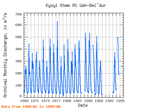
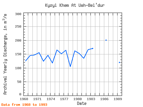
| Year | Jan | Feb | Mar | Apr | May | Jun | Jul | Aug | Sep | Oct | Nov | Dec | Annual | 1968 | 50.10 | 46.10 | 44.80 | 65.40 | 224.00 | 223.00 | 198.00 | 260.00 | 204.00 | 104.00 | 41.60 | 37.80 | 124.90 | 1969 | 38.30 | 30.90 | 37.40 | 68.40 | 317.00 | 444.00 | 203.00 | 187.00 | 213.00 | 90.90 | 51.00 | 54.00 | 144.57 | 1970 | 34.70 | 35.80 | 37.20 | 45.60 | 225.00 | 364.00 | 239.00 | 284.00 | 266.00 | 140.00 | 46.60 | 42.50 | 146.70 | 1971 | 40.20 | 40.30 | 41.00 | 67.60 | 218.00 | 288.00 | 338.00 | 377.00 | 213.00 | 117.00 | 74.70 | 50.20 | 155.42 | 1972 | 50.20 | 37.70 | 34.20 | 105.00 | 195.00 | 303.00 | 254.00 | 213.00 | 121.00 | 85.40 | 45.80 | 48.80 | 124.42 | 1973 | 40.20 | 32.70 | 31.50 | 41.30 | 148.00 | 477.00 | 357.00 | 233.00 | 181.00 | 100.00 | 53.50 | 50.00 | 145.43 | 1974 | 42.80 | 36.20 | 36.90 | 85.70 | 197.00 | 300.00 | 204.00 | 194.00 | 145.00 | 86.60 | 31.40 | 48.70 | 117.36 | 1975 | 46.40 | 34.70 | 35.30 | 49.50 | 364.00 | 483.00 | 338.00 | 235.00 | 167.00 | 121.00 | 64.50 | 43.10 | 165.12 | 1976 | 39.80 | 33.90 | 30.80 | 31.40 | 303.00 | 442.00 | 291.00 | 238.00 | 172.00 | 112.00 | 72.30 | 53.00 | 151.60 | 1977 | 41.20 | 29.80 | 31.00 | 58.20 | 197.00 | 629.00 | 316.00 | 276.00 | 159.00 | 118.00 | 59.20 | 59.20 | 164.47 | 1978 | 37.30 | 27.90 | 29.20 | 36.50 | 164.00 | 338.00 | 179.00 | 145.00 | 130.00 | 92.90 | 38.50 | 38.00 | 104.69 | 1979 | 20.60 | 19.00 | 16.80 | 436.00 | 332.00 | 345.00 | 223.00 | 181.00 | 166.00 | 117.00 | 48.20 | 43.60 | 162.35 | 1980 | 36.20 | 33.10 | 32.70 | 38.00 | 310.00 | 480.00 | 278.00 | 244.00 | 181.00 | 109.00 | 42.10 | 36.20 | 151.69 | 1981 | 35.90 | 33.60 | 30.10 | 64.10 | 294.00 | 190.00 | 210.00 | 380.00 | 175.00 | 106.00 | 58.50 | 44.90 | 135.18 | 1982 | 42.50 | 38.70 | 34.60 | 102.00 | 360.00 | 437.00 | 261.00 | 290.00 | 200.00 | 115.00 | 65.20 | 52.60 | 166.55 | 1983 | 48.90 | 46.60 | 37.10 | 39.00 | 169.00 | 438.00 | 471.00 | 344.00 | 217.00 | 129.00 | 71.30 | 36.80 | 170.64 | 1984 | 36.30 | 38.20 | 37.10 | 1985 | 53.80 | 533.00 | 454.00 | 313.00 | 219.00 | 154.00 | 99.50 | 54.10 | 45.50 | 1986 | 42.90 | 38.60 | 35.80 | 64.10 | 469.00 | 417.00 | 533.00 | 328.00 | 227.00 | 138.00 | 68.40 | 47.40 | 200.77 | 1987 | 46.60 | 43.50 | 40.30 | 431.00 | 364.00 | 338.00 | 245.00 | 196.00 | 50.30 | 1988 | 28.20 | 25.00 | 22.70 | 46.40 | 256.00 | 505.00 | 390.00 | 259.00 | 170.00 | 119.00 | 59.10 | 40.90 | 160.11 | 1989 | 33.20 | 27.10 | 29.50 | 39.30 | 186.00 | 207.00 | 289.00 | 302.00 | 169.00 | 107.00 | 29.80 | 22.60 | 120.12 | 1993 | 41.00 | 35.50 | 39.80 | 60.00 | 194.00 | 334.00 | 253.00 | 372.00 | 247.00 | 154.00 | 80.50 | 61.40 | 156.02 | 1994 | 496.00 | 399.00 | 233.00 | 191.00 | 1995 | 407.00 | 257.00 | 325.00 |
|---|
 Return to R-Arctic Net Home Page