|
|
|||||||||||||||||
| Point ID: 6554 | Downloads | Plots | Site Data | Code: 9125 |
|
|
|||||||||||||||||
| Download | |
|---|---|
| Site Descriptor Information | Site Time Series Data |
| Link to all available data | |
|
|
| View: | Statistics | Time Series |
| Units: | mm |
| Statistic | Jan | Feb | Mar | Apr | May | Jun | Jul | Aug | Sep | Oct | Nov | Dec | Annual |
|---|---|---|---|---|---|---|---|---|---|---|---|---|---|
| Mean | 101.26 | 87.68 | 86.84 | 164.67 | 829.89 | 1065.06 | 817.91 | 738.34 | 516.43 | 292.59 | 138.29 | 110.18 | 417.42 |
| Standard Deviation | 13.80 | 10.52 | 11.06 | 60.37 | 220.89 | 312.73 | 247.21 | 212.47 | 119.83 | 55.35 | 30.44 | 19.07 | 65.84 |
| Min | 69.60 | 61.70 | 63.80 | 69.40 | 267.00 | 523.00 | 416.00 | 393.00 | 330.00 | 186.00 | 72.70 | 77.90 | 299.92 |
| Max | 128.00 | 107.00 | 112.00 | 332.00 | 1270.00 | 1980.00 | 1430.00 | 1320.00 | 848.00 | 433.00 | 220.00 | 145.00 | 624.42 |
| Coefficient of Variation | 0.14 | 0.12 | 0.13 | 0.37 | 0.27 | 0.29 | 0.30 | 0.29 | 0.23 | 0.19 | 0.22 | 0.17 | 0.16 |
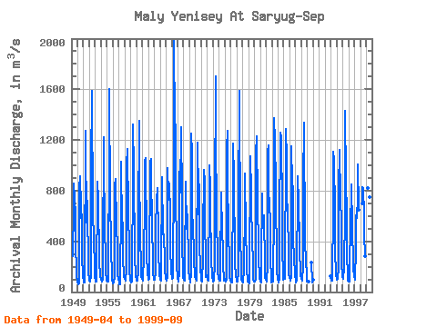
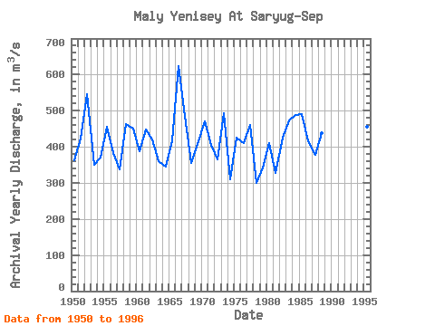
| Year | Jan | Feb | Mar | Apr | May | Jun | Jul | Aug | Sep | Oct | Nov | Dec | Annual | 1949 | 282.00 | 671.00 | 856.00 | 741.00 | 598.00 | 334.00 | 208.00 | 120.00 | 86.80 | 1950 | 84.00 | 62.20 | 63.80 | 69.40 | 820.00 | 914.00 | 585.00 | 793.00 | 437.00 | 251.00 | 152.00 | 120.00 | 362.62 | 1951 | 89.60 | 72.00 | 75.80 | 94.40 | 1270.00 | 913.00 | 550.00 | 872.00 | 567.00 | 305.00 | 163.00 | 94.60 | 422.20 | 1952 | 91.20 | 85.50 | 85.10 | 130.00 | 981.00 | 1590.00 | 1430.00 | 773.00 | 655.00 | 393.00 | 217.00 | 117.00 | 545.65 | 1953 | 100.00 | 81.00 | 82.00 | 163.00 | 740.00 | 868.00 | 726.00 | 614.00 | 366.00 | 252.00 | 116.00 | 105.00 | 351.08 | 1954 | 98.30 | 85.10 | 85.10 | 107.00 | 267.00 | 1220.00 | 907.00 | 657.00 | 482.00 | 288.00 | 165.00 | 88.70 | 370.85 | 1955 | 80.90 | 79.00 | 83.10 | 91.80 | 1140.00 | 1600.00 | 708.00 | 573.00 | 542.00 | 295.00 | 169.00 | 94.80 | 454.72 | 1956 | 69.60 | 72.40 | 73.80 | 118.00 | 835.00 | 892.00 | 795.00 | 619.00 | 558.00 | 312.00 | 140.00 | 95.20 | 381.67 | 1957 | 85.60 | 61.70 | 64.30 | 128.00 | 624.00 | 1030.00 | 498.00 | 496.00 | 548.00 | 254.00 | 138.00 | 129.00 | 338.05 | 1958 | 101.00 | 89.50 | 93.90 | 171.00 | 1000.00 | 1130.00 | 937.00 | 804.00 | 685.00 | 289.00 | 140.00 | 124.00 | 463.70 | 1959 | 99.20 | 75.90 | 84.70 | 176.00 | 880.00 | 1320.00 | 971.00 | 724.00 | 519.00 | 284.00 | 135.00 | 125.00 | 449.48 | 1960 | 104.00 | 92.90 | 88.60 | 161.00 | 559.00 | 1350.00 | 807.00 | 615.00 | 400.00 | 245.00 | 117.00 | 113.00 | 387.71 | 1961 | 105.00 | 95.50 | 88.30 | 295.00 | 682.00 | 1030.00 | 1060.00 | 900.00 | 547.00 | 292.00 | 148.00 | 130.00 | 447.73 | 1962 | 118.00 | 100.00 | 103.00 | 184.00 | 1020.00 | 1050.00 | 833.00 | 623.00 | 466.00 | 299.00 | 140.00 | 118.00 | 421.17 | 1963 | 100.00 | 98.40 | 112.00 | 138.00 | 506.00 | 720.00 | 823.00 | 707.00 | 551.00 | 310.00 | 146.00 | 122.00 | 361.12 | 1964 | 120.00 | 96.20 | 89.60 | 144.00 | 907.00 | 903.00 | 470.00 | 423.00 | 456.00 | 242.00 | 152.00 | 122.00 | 343.73 | 1965 | 109.00 | 91.40 | 91.50 | 123.00 | 981.00 | 771.00 | 725.00 | 855.00 | 620.00 | 338.00 | 172.00 | 142.00 | 418.24 | 1966 | 128.00 | 103.00 | 108.00 | 136.00 | 947.00 | 1980.00 | 1330.00 | 1320.00 | 691.00 | 424.00 | 181.00 | 145.00 | 624.42 | 1967 | 108.00 | 91.40 | 84.70 | 156.00 | 864.00 | 1040.00 | 784.00 | 1300.00 | 734.00 | 394.00 | 152.00 | 109.00 | 484.76 | 1968 | 109.00 | 96.50 | 92.20 | 169.00 | 873.00 | 636.00 | 495.00 | 677.00 | 553.00 | 274.00 | 144.00 | 135.00 | 354.48 | 1969 | 111.00 | 89.30 | 74.00 | 145.00 | 1250.00 | 1090.00 | 530.00 | 520.00 | 569.00 | 263.00 | 123.00 | 117.00 | 406.77 | 1970 | 122.00 | 107.00 | 90.10 | 131.00 | 1180.00 | 1020.00 | 610.00 | 970.00 | 733.00 | 386.00 | 185.00 | 114.00 | 470.68 | 1971 | 90.00 | 90.10 | 85.80 | 278.00 | 639.00 | 747.00 | 962.00 | 873.00 | 559.00 | 275.00 | 118.00 | 135.00 | 404.32 | 1972 | 114.00 | 98.10 | 89.90 | 265.00 | 600.00 | 999.00 | 816.00 | 554.00 | 377.00 | 245.00 | 131.00 | 85.00 | 364.50 | 1973 | 101.00 | 91.50 | 93.10 | 226.00 | 715.00 | 1700.00 | 1110.00 | 754.00 | 550.00 | 304.00 | 160.00 | 101.00 | 492.13 | 1974 | 103.00 | 90.60 | 86.70 | 242.00 | 714.00 | 786.00 | 468.00 | 463.00 | 345.00 | 225.00 | 90.00 | 98.80 | 309.34 | 1975 | 101.00 | 91.40 | 83.60 | 100.00 | 1130.00 | 1270.00 | 714.00 | 672.00 | 458.00 | 263.00 | 121.00 | 96.80 | 425.07 | 1976 | 90.00 | 76.60 | 76.60 | 127.00 | 824.00 | 1170.00 | 907.00 | 719.00 | 449.00 | 235.00 | 129.00 | 125.00 | 410.68 | 1977 | 98.10 | 79.40 | 83.60 | 155.00 | 649.00 | 1590.00 | 1290.00 | 755.00 | 387.00 | 257.00 | 104.00 | 85.30 | 461.12 | 1978 | 79.60 | 77.60 | 87.00 | 168.00 | 695.00 | 936.00 | 474.00 | 393.00 | 330.00 | 186.00 | 87.80 | 85.00 | 299.92 | 1979 | 82.60 | 76.70 | 70.90 | 96.90 | 1070.00 | 791.00 | 660.00 | 432.00 | 398.00 | 243.00 | 104.00 | 80.60 | 342.14 | 1980 | 82.30 | 82.60 | 79.70 | 101.00 | 1090.00 | 1230.00 | 697.00 | 609.00 | 449.00 | 272.00 | 117.00 | 105.00 | 409.55 | 1981 | 94.30 | 80.80 | 75.90 | 227.00 | 781.00 | 523.00 | 504.00 | 608.00 | 546.00 | 270.00 | 111.00 | 97.40 | 326.53 | 1982 | 93.20 | 80.20 | 80.50 | 211.00 | 1110.00 | 1160.00 | 671.00 | 745.00 | 499.00 | 266.00 | 96.70 | 77.90 | 424.21 | 1983 | 94.80 | 90.30 | 81.30 | 91.80 | 653.00 | 1370.00 | 1190.00 | 851.00 | 606.00 | 391.00 | 165.00 | 96.40 | 473.38 | 1984 | 98.90 | 85.60 | 73.80 | 110.00 | 730.00 | 1050.00 | 1260.00 | 1220.00 | 651.00 | 345.00 | 132.00 | 99.00 | 487.94 | 1985 | 115.00 | 103.00 | 103.00 | 152.00 | 1120.00 | 1290.00 | 1040.00 | 755.00 | 625.00 | 320.00 | 136.00 | 126.00 | 490.42 | 1986 | 114.00 | 96.30 | 92.90 | 122.00 | 1150.00 | 782.00 | 1000.00 | 676.00 | 416.00 | 270.00 | 146.00 | 130.00 | 416.27 | 1987 | 99.30 | 78.30 | 100.00 | 207.00 | 752.00 | 917.00 | 704.00 | 727.00 | 370.00 | 348.00 | 137.00 | 102.00 | 378.47 | 1988 | 108.00 | 95.00 | 86.90 | 206.00 | 859.00 | 1340.00 | 1100.00 | 627.00 | 368.00 | 279.00 | 104.00 | 84.20 | 438.09 | 1989 | 92.80 | 84.30 | 82.00 | 236.00 | 72.70 | 99.10 | 1993 | 125.00 | 87.90 | 88.10 | 156.00 | 600.00 | 1110.00 | 899.00 | 1070.00 | 595.00 | 338.00 | 133.00 | 130.00 | 444.33 | 1994 | 112.00 | 100.00 | 101.00 | 193.00 | 805.00 | 1120.00 | 956.00 | 897.00 | 848.00 | 433.00 | 220.00 | 136.00 | 493.42 | 1995 | 123.00 | 102.00 | 111.00 | 184.00 | 629.00 | 1430.00 | 878.00 | 988.00 | 495.00 | 297.00 | 135.00 | 90.40 | 455.20 | 1996 | 87.20 | 83.60 | 80.00 | 147.00 | 574.00 | 741.00 | 847.00 | 512.00 | 440.00 | 281.00 | 158.00 | 145.00 | 341.32 | 1997 | 124.00 | 98.00 | 101.00 | 332.00 | 603.00 | 586.00 | 750.00 | 1010.00 | 651.00 | 1998 | 696.00 | 831.00 | 814.00 | 611.00 | 454.00 | 282.00 | 1999 | 820.00 | 666.00 | 416.00 | 748.00 | 393.00 |
|---|
 Return to R-Arctic Net Home Page
