|
|
|||||||||||||||||
| Point ID: 6553 | Downloads | Plots | Site Data | Code: 9124 |
|
|
|||||||||||||||||
| Download | |
|---|---|
| Site Descriptor Information | Site Time Series Data |
| Link to all available data | |
|
|
| View: | Statistics | Time Series |
| Units: | mm |
| Statistic | Jan | Feb | Mar | Apr | May | Jun | Jul | Aug | Sep | Oct | Nov | Dec | Annual |
|---|---|---|---|---|---|---|---|---|---|---|---|---|---|
| Mean | 77.64 | 70.05 | 67.85 | 112.16 | 656.51 | 895.49 | 683.11 | 618.83 | 415.37 | 236.86 | 99.80 | 86.81 | 332.68 |
| Standard Deviation | 17.71 | 13.05 | 13.09 | 44.65 | 200.34 | 301.11 | 214.83 | 205.38 | 108.78 | 57.57 | 25.09 | 20.30 | 61.71 |
| Min | 40.10 | 38.50 | 35.20 | 54.70 | 94.90 | 430.00 | 343.00 | 312.00 | 258.00 | 142.00 | 54.80 | 51.00 | 245.38 |
| Max | 114.00 | 92.50 | 97.30 | 292.00 | 1010.00 | 1760.00 | 1120.00 | 1140.00 | 737.00 | 379.00 | 157.00 | 133.00 | 514.43 |
| Coefficient of Variation | 0.23 | 0.19 | 0.19 | 0.40 | 0.30 | 0.34 | 0.31 | 0.33 | 0.26 | 0.24 | 0.25 | 0.23 | 0.18 |
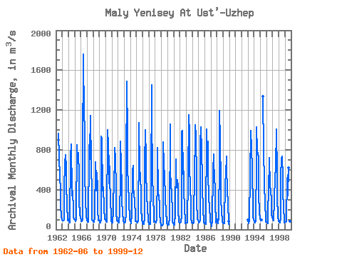
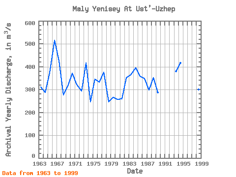
| Year | Jan | Feb | Mar | Apr | May | Jun | Jul | Aug | Sep | Oct | Nov | Dec | Annual | 1962 | 962.00 | 722.00 | 538.00 | 383.00 | 243.00 | 124.00 | 96.80 | 1963 | 91.90 | 92.50 | 88.30 | 99.20 | 407.00 | 662.00 | 752.00 | 628.00 | 455.00 | 244.00 | 92.50 | 108.00 | 310.03 | 1964 | 93.20 | 72.40 | 69.80 | 104.00 | 731.00 | 854.00 | 379.00 | 337.00 | 382.00 | 199.00 | 124.00 | 106.00 | 287.62 | 1965 | 94.40 | 83.00 | 82.70 | 101.00 | 851.00 | 731.00 | 662.00 | 770.00 | 550.00 | 291.00 | 148.00 | 121.00 | 373.76 | 1966 | 97.20 | 85.10 | 83.90 | 107.00 | 779.00 | 1760.00 | 1120.00 | 1060.00 | 552.00 | 298.00 | 126.00 | 105.00 | 514.43 | 1967 | 87.40 | 73.10 | 75.30 | 114.00 | 739.00 | 955.00 | 708.00 | 1140.00 | 639.00 | 379.00 | 99.60 | 89.60 | 424.92 | 1968 | 78.00 | 77.40 | 74.60 | 123.00 | 676.00 | 516.00 | 394.00 | 573.00 | 422.00 | 192.00 | 90.00 | 98.30 | 276.19 | 1969 | 81.80 | 68.90 | 67.80 | 103.00 | 939.00 | 910.00 | 392.00 | 382.00 | 423.00 | 212.00 | 101.00 | 103.00 | 315.29 | 1970 | 101.00 | 79.30 | 73.90 | 96.70 | 999.00 | 853.00 | 459.00 | 743.00 | 526.00 | 285.00 | 142.00 | 87.50 | 370.45 | 1971 | 68.70 | 67.90 | 75.20 | 185.00 | 542.00 | 625.00 | 818.00 | 705.00 | 427.00 | 160.00 | 90.50 | 82.40 | 320.56 | 1972 | 91.90 | 74.90 | 69.40 | 173.00 | 497.00 | 885.00 | 642.00 | 460.00 | 292.00 | 172.00 | 87.90 | 71.60 | 293.06 | 1973 | 68.40 | 70.20 | 73.30 | 163.00 | 633.00 | 1490.00 | 945.00 | 603.00 | 469.00 | 269.00 | 111.00 | 94.10 | 415.75 | 1974 | 82.90 | 79.30 | 61.50 | 147.00 | 586.00 | 642.00 | 367.00 | 387.00 | 258.00 | 177.00 | 79.80 | 85.90 | 246.12 | 1975 | 85.60 | 75.70 | 68.30 | 81.40 | 892.00 | 1070.00 | 606.00 | 532.00 | 362.00 | 216.00 | 94.00 | 71.30 | 346.19 | 1976 | 64.10 | 57.30 | 56.70 | 110.00 | 661.00 | 998.00 | 720.00 | 570.00 | 354.00 | 195.00 | 108.00 | 85.10 | 331.60 | 1977 | 52.30 | 51.90 | 54.20 | 97.10 | 462.00 | 1450.00 | 1120.00 | 597.00 | 278.00 | 194.00 | 74.70 | 79.40 | 375.88 | 1978 | 72.50 | 68.20 | 65.50 | 98.60 | 577.00 | 822.00 | 387.00 | 312.00 | 274.00 | 161.00 | 73.80 | 51.00 | 246.88 | 1979 | 40.10 | 38.50 | 38.90 | 54.70 | 877.00 | 650.00 | 533.00 | 341.00 | 304.00 | 183.00 | 75.20 | 59.90 | 266.27 | 1980 | 47.00 | 47.40 | 46.80 | 64.70 | 94.90 | 1060.00 | 549.00 | 480.00 | 343.00 | 207.00 | 83.80 | 63.70 | 257.27 | 1981 | 48.90 | 49.60 | 60.30 | 146.00 | 704.00 | 430.00 | 417.00 | 497.00 | 423.00 | 198.00 | 78.60 | 69.90 | 260.19 | 1982 | 65.30 | 66.60 | 73.40 | 138.00 | 987.00 | 996.00 | 558.00 | 584.00 | 396.00 | 219.00 | 71.90 | 61.10 | 351.36 | 1983 | 66.90 | 68.00 | 70.00 | 78.20 | 504.00 | 1150.00 | 948.00 | 639.00 | 417.00 | 259.00 | 118.00 | 67.70 | 365.48 | 1984 | 66.40 | 66.40 | 62.20 | 70.40 | 622.00 | 868.00 | 1050.00 | 940.00 | 519.00 | 276.00 | 106.00 | 86.40 | 394.40 | 1985 | 78.70 | 71.60 | 76.10 | 100.00 | 863.00 | 1030.00 | 783.00 | 522.00 | 407.00 | 218.00 | 70.20 | 65.30 | 357.07 | 1986 | 63.90 | 62.00 | 59.30 | 55.50 | 1010.00 | 726.00 | 882.00 | 554.00 | 330.00 | 212.00 | 121.00 | 81.80 | 346.46 | 1987 | 64.00 | 49.60 | 35.20 | 91.40 | 581.00 | 758.00 | 608.00 | 592.00 | 341.00 | 266.00 | 70.30 | 106.00 | 296.88 | 1988 | 105.00 | 85.10 | 57.60 | 128.00 | 679.00 | 1190.00 | 892.00 | 463.00 | 287.00 | 190.00 | 78.10 | 59.60 | 351.20 | 1989 | 61.40 | 59.10 | 61.90 | 84.70 | 465.00 | 548.00 | 732.00 | 635.00 | 379.00 | 276.00 | 54.80 | 83.40 | 286.69 | 1993 | 98.10 | 59.80 | 63.10 | 99.80 | 541.00 | 990.00 | 769.00 | 902.00 | 532.00 | 280.00 | 115.00 | 114.00 | 380.32 | 1994 | 76.50 | 74.40 | 67.70 | 82.20 | 723.00 | 1030.00 | 794.00 | 747.00 | 737.00 | 366.00 | 157.00 | 133.00 | 415.65 | 1995 | 114.00 | 91.90 | 97.30 | 1340.00 | 783.00 | 836.00 | 443.00 | 270.00 | 100.00 | 78.20 | 1996 | 74.70 | 69.50 | 63.60 | 95.80 | 480.00 | 605.00 | 718.00 | 436.00 | 395.00 | 284.00 | 140.00 | 129.00 | 290.88 | 1997 | 100.00 | 91.00 | 86.70 | 292.00 | 535.00 | 525.00 | 623.00 | 1010.00 | 554.00 | 339.00 | 118.00 | 91.20 | 363.74 | 1998 | 84.50 | 76.20 | 66.20 | 114.00 | 537.00 | 713.00 | 734.00 | 524.00 | 384.00 | 218.00 | 87.80 | 67.20 | 300.49 | 1999 | 73.00 | 77.90 | 80.20 | 103.00 | 491.00 | 548.00 | 343.00 | 620.00 | 301.00 | 142.00 | 80.40 | 85.00 | 245.38 |
|---|
 Return to R-Arctic Net Home Page
