|
|
|||||||||||||||||
| Point ID: 6514 | Downloads | Plots | Site Data | Code: 8335 |
|
|
|||||||||||||||||
| Download | |
|---|---|
| Site Descriptor Information | Site Time Series Data |
| Link to all available data | |
|
|
| View: | Statistics | Time Series |
| Units: | mm |
| Statistic | Jan | Feb | Mar | Apr | May | Jun | Jul | Aug | Sep | Oct | Nov | Dec | Annual |
|---|---|---|---|---|---|---|---|---|---|---|---|---|---|
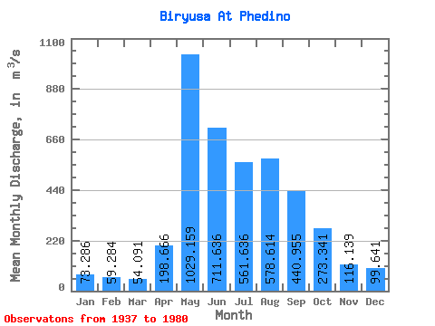
| Mean | 73.29 | 59.28 | 54.09 | 198.67 | 1029.16 | 711.64 | 561.64 | 578.61 | 440.95 | 273.34 | 116.14 | 99.64 | 349.70 |
| Standard Deviation | 13.84 | 11.45 | 10.44 | 153.47 | 329.55 | 250.84 | 181.14 | 244.08 | 171.67 | 82.50 | 37.55 | 28.14 | 69.53 |
| Min | 45.30 | 38.50 | 32.80 | 55.60 | 523.00 | 331.00 | 264.00 | 169.00 | 209.00 | 172.00 | 67.30 | 60.20 | 204.82 |
| Max | 105.00 | 85.40 | 82.50 | 697.00 | 2070.00 | 1480.00 | 1050.00 | 1540.00 | 1240.00 | 555.00 | 227.00 | 232.00 | 500.05 |
| Coefficient of Variation | 0.19 | 0.19 | 0.19 | 0.77 | 0.32 | 0.35 | 0.32 | 0.42 | 0.39 | 0.30 | 0.32 | 0.28 | 0.20 |
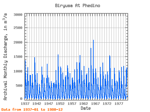
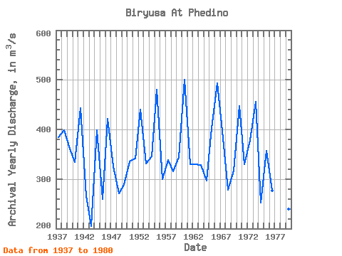
| Year | Jan | Feb | Mar | Apr | May | Jun | Jul | Aug | Sep | Oct | Nov | Dec | Annual | 1937 | 95.30 | 72.70 | 61.10 | 67.10 | 1360.00 | 496.00 | 545.00 | 687.00 | 523.00 | 413.00 | 190.00 | 96.70 | 383.91 | 1938 | 66.30 | 59.20 | 52.60 | 671.00 | 1120.00 | 742.00 | 522.00 | 652.00 | 423.00 | 237.00 | 136.00 | 99.20 | 398.36 | 1939 | 83.00 | 75.00 | 69.00 | 394.00 | 860.00 | 510.00 | 860.00 | 624.00 | 374.00 | 211.00 | 151.00 | 123.00 | 361.17 | 1940 | 88.40 | 78.80 | 73.00 | 281.00 | 887.00 | 738.00 | 466.00 | 417.00 | 486.00 | 250.00 | 131.00 | 105.00 | 333.43 | 1941 | 76.30 | 55.80 | 50.80 | 60.30 | 1470.00 | 1100.00 | 625.00 | 847.00 | 555.00 | 283.00 | 96.20 | 99.80 | 443.27 | 1942 | 73.80 | 65.20 | 55.90 | 115.00 | 922.00 | 715.00 | 443.00 | 226.00 | 229.00 | 176.00 | 96.20 | 70.90 | 265.67 | 1943 | 55.70 | 38.70 | 42.30 | 325.00 | 538.00 | 331.00 | 264.00 | 255.00 | 256.00 | 172.00 | 85.40 | 94.70 | 204.82 | 1944 | 74.10 | 57.60 | 51.90 | 223.00 | 1150.00 | 667.00 | 590.00 | 865.00 | 538.00 | 306.00 | 149.00 | 108.00 | 398.30 | 1945 | 89.40 | 67.80 | 58.90 | 490.00 | 764.00 | 357.00 | 294.00 | 331.00 | 295.00 | 214.00 | 85.20 | 73.50 | 259.98 | 1946 | 63.20 | 53.90 | 50.70 | 197.00 | 672.00 | 744.00 | 684.00 | 596.00 | 1240.00 | 454.00 | 190.00 | 110.00 | 421.23 | 1947 | 85.10 | 63.20 | 50.00 | 697.00 | 767.00 | 422.00 | 495.00 | 433.00 | 467.00 | 275.00 | 72.20 | 83.30 | 325.82 | 1948 | 59.70 | 57.30 | 54.00 | 227.00 | 633.00 | 643.00 | 511.00 | 395.00 | 299.00 | 228.00 | 77.40 | 60.20 | 270.38 | 1949 | 45.30 | 42.40 | 43.80 | 241.00 | 576.00 | 448.00 | 592.00 | 527.00 | 543.00 | 249.00 | 83.30 | 66.00 | 288.07 | 1950 | 45.90 | 40.70 | 36.90 | 55.60 | 1030.00 | 915.00 | 431.00 | 527.00 | 465.00 | 277.00 | 109.00 | 93.50 | 335.55 | 1951 | 73.20 | 59.10 | 49.20 | 70.10 | 1560.00 | 724.00 | 442.00 | 408.00 | 359.00 | 193.00 | 76.40 | 73.20 | 340.60 | 1952 | 66.40 | 55.80 | 48.70 | 65.20 | 983.00 | 1140.00 | 1050.00 | 739.00 | 473.00 | 410.00 | 139.00 | 109.00 | 439.93 | 1953 | 77.20 | 66.70 | 61.30 | 453.00 | 937.00 | 493.00 | 514.00 | 687.00 | 318.00 | 210.00 | 67.30 | 83.30 | 330.65 | 1954 | 70.50 | 57.40 | 48.10 | 63.40 | 523.00 | 775.00 | 774.00 | 845.00 | 467.00 | 284.00 | 147.00 | 99.60 | 346.17 | 1955 | 63.80 | 55.80 | 53.30 | 93.20 | 1190.00 | 1010.00 | 905.00 | 723.00 | 790.00 | 555.00 | 184.00 | 133.00 | 479.68 | 1956 | 89.70 | 73.50 | 63.70 | 127.00 | 917.00 | 623.00 | 456.00 | 323.00 | 490.00 | 262.00 | 94.40 | 73.70 | 299.42 | 1957 | 49.10 | 38.50 | 32.80 | 142.00 | 726.00 | 765.00 | 393.00 | 688.00 | 499.00 | 421.00 | 177.00 | 127.00 | 338.20 | 1958 | 92.80 | 74.50 | 67.20 | 187.00 | 1050.00 | 780.00 | 424.00 | 463.00 | 262.00 | 215.00 | 87.80 | 76.60 | 314.99 | 1959 | 66.60 | 64.00 | 62.50 | 146.00 | 1300.00 | 828.00 | 536.00 | 361.00 | 329.00 | 240.00 | 107.00 | 91.90 | 344.33 | 1960 | 61.40 | 54.10 | 57.10 | 150.00 | 1290.00 | 687.00 | 611.00 | 1540.00 | 714.00 | 377.00 | 227.00 | 232.00 | 500.05 | 1961 | 98.00 | 85.40 | 82.50 | 61.20 | 1020.00 | 708.00 | 580.00 | 496.00 | 408.00 | 225.00 | 91.70 | 96.80 | 329.38 | 1962 | 79.60 | 62.80 | 63.90 | 177.00 | 1170.00 | 561.00 | 705.00 | 461.00 | 306.00 | 233.00 | 72.00 | 71.90 | 330.27 | 1963 | 73.30 | 65.50 | 64.50 | 127.00 | 866.00 | 551.00 | 906.00 | 570.00 | 330.00 | 209.00 | 92.80 | 92.40 | 328.96 | 1964 | 69.30 | 44.60 | 41.50 | 63.20 | 1100.00 | 433.00 | 346.00 | 608.00 | 519.00 | 180.00 | 77.70 | 85.70 | 297.33 | 1965 | 69.20 | 55.20 | 52.50 | 136.00 | 1790.00 | 588.00 | 534.00 | 515.00 | 492.00 | 334.00 | 143.00 | 122.00 | 402.57 | 1966 | 89.50 | 70.00 | 68.80 | 77.10 | 2070.00 | 1270.00 | 563.00 | 742.00 | 469.00 | 267.00 | 108.00 | 124.00 | 493.20 | 1967 | 82.00 | 63.40 | 61.50 | 257.00 | 1080.00 | 798.00 | 660.00 | 638.00 | 447.00 | 287.00 | 111.00 | 117.00 | 383.49 | 1968 | 85.70 | 57.60 | 53.70 | 296.00 | 774.00 | 492.00 | 387.00 | 363.00 | 346.00 | 303.00 | 96.70 | 87.50 | 278.52 | 1969 | 71.70 | 56.00 | 44.60 | 84.40 | 1130.00 | 640.00 | 354.00 | 469.00 | 436.00 | 267.00 | 138.00 | 113.00 | 316.98 | 1970 | 80.50 | 70.20 | 55.40 | 145.00 | 1280.00 | 1070.00 | 879.00 | 790.00 | 408.00 | 400.00 | 106.00 | 83.70 | 447.32 | 1971 | 70.40 | 57.70 | 39.30 | 210.00 | 728.00 | 484.00 | 579.00 | 880.00 | 419.00 | 257.00 | 113.00 | 113.00 | 329.20 | 1972 | 72.80 | 52.90 | 52.70 | 362.00 | 683.00 | 971.00 | 761.00 | 553.00 | 464.00 | 280.00 | 151.00 | 132.00 | 377.95 | 1973 | 105.00 | 79.50 | 69.40 | 180.00 | 1530.00 | 1480.00 | 699.00 | 531.00 | 359.00 | 233.00 | 109.00 | 99.00 | 456.16 | 1974 | 75.80 | 48.90 | 43.20 | 296.00 | 711.00 | 493.00 | 313.00 | 296.00 | 335.00 | 221.00 | 112.00 | 84.30 | 252.43 | 1975 | 69.80 | 58.40 | 52.90 | 140.00 | 1100.00 | 700.00 | 586.00 | 516.00 | 579.00 | 297.00 | 102.00 | 90.50 | 357.63 | 1976 | 68.70 | 57.50 | 53.90 | 88.00 | 656.00 | 451.00 | 634.00 | 602.00 | 352.00 | 201.00 | 75.90 | 80.20 | 276.68 | 1977 | 54.10 | 39.70 | 39.30 | 240.00 | 1020.00 | 885.00 | 628.00 | 471.00 | 333.00 | 252.00 | 142.00 | 122.00 | 352.18 | 1978 | 81.50 | 64.60 | 55.60 | 141.00 | 1130.00 | 619.00 | 428.00 | 530.00 | 289.00 | 200.00 | 78.90 | 68.80 | 307.20 | 1979 | 52.20 | 42.80 | 46.70 | 59.90 | 1170.00 | 476.00 | 271.00 | 169.00 | 209.00 | 185.00 | 97.60 | 92.30 | 239.29 | 1980 | 63.30 | 48.10 | 43.30 | 59.60 | 1050.00 | 989.00 | 472.00 | 1100.00 | 508.00 | 284.00 | 133.00 | 125.00 | 406.27 |
|---|
 Return to R-Arctic Net Home Page