|
|
|||||||||||||||||
| Point ID: 6495 | Downloads | Plots | Site Data | Code: 8288 |
|
|
|||||||||||||||||
| Download | |
|---|---|
| Site Descriptor Information | Site Time Series Data |
| Link to all available data | |
|
|
| View: | Statistics | Time Series |
| Units: | mm |
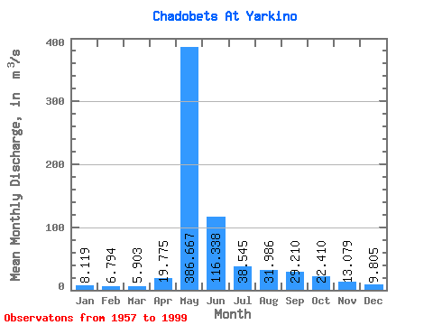
| Statistic | Jan | Feb | Mar | Apr | May | Jun | Jul | Aug | Sep | Oct | Nov | Dec | Annual |
|---|---|---|---|---|---|---|---|---|---|---|---|---|---|
| Mean | 8.12 | 6.79 | 5.90 | 19.77 | 386.67 | 116.34 | 38.55 | 31.99 | 29.21 | 22.41 | 13.08 | 9.80 | 57.39 |
| Standard Deviation | 4.13 | 3.19 | 2.88 | 47.78 | 107.96 | 71.72 | 17.76 | 25.92 | 12.50 | 10.21 | 6.96 | 4.56 | 15.23 |
| Min | 3.03 | 2.24 | 1.51 | 2.01 | 167.00 | 33.50 | 17.10 | 14.70 | 12.80 | 8.45 | 4.84 | 3.25 | 27.07 |
| Max | 26.50 | 17.40 | 14.20 | 302.00 | 627.00 | 422.00 | 90.70 | 156.00 | 66.70 | 50.70 | 41.70 | 29.90 | 111.44 |
| Coefficient of Variation | 0.51 | 0.47 | 0.49 | 2.42 | 0.28 | 0.62 | 0.46 | 0.81 | 0.43 | 0.46 | 0.53 | 0.47 | 0.27 |
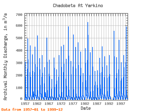
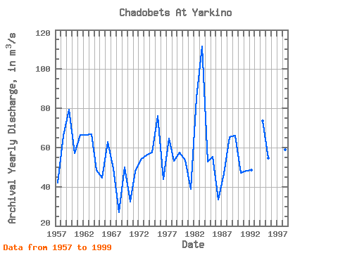
| Year | Jan | Feb | Mar | Apr | May | Jun | Jul | Aug | Sep | Oct | Nov | Dec | Annual | 1957 | 8.35 | 6.27 | 3.96 | 3.68 | 307.00 | 69.80 | 26.50 | 19.40 | 22.10 | 20.40 | 8.61 | 8.06 | 42.01 | 1958 | 7.00 | 5.45 | 5.71 | 6.30 | 492.00 | 157.00 | 35.80 | 24.30 | 19.90 | 15.50 | 12.60 | 9.88 | 65.95 | 1959 | 6.22 | 6.61 | 6.52 | 7.27 | 439.00 | 331.00 | 41.80 | 33.40 | 30.20 | 23.00 | 15.90 | 9.18 | 79.17 | 1960 | 7.78 | 6.30 | 5.93 | 6.84 | 364.00 | 98.10 | 29.80 | 26.70 | 66.70 | 33.40 | 20.80 | 16.80 | 56.93 | 1961 | 11.30 | 9.95 | 9.58 | 17.10 | 427.00 | 146.00 | 40.40 | 34.10 | 37.80 | 30.80 | 19.00 | 12.90 | 66.33 | 1962 | 11.20 | 9.75 | 9.08 | 11.20 | 517.00 | 121.00 | 33.30 | 24.40 | 24.70 | 16.30 | 10.70 | 6.88 | 66.29 | 1963 | 6.84 | 6.66 | 7.18 | 7.35 | 335.00 | 157.00 | 80.90 | 53.10 | 49.00 | 48.90 | 32.80 | 17.20 | 66.83 | 1964 | 15.00 | 14.20 | 7.02 | 9.51 | 360.00 | 74.10 | 32.40 | 19.30 | 18.50 | 13.70 | 10.70 | 9.13 | 48.63 | 1965 | 6.56 | 5.48 | 4.50 | 3.30 | 262.00 | 69.10 | 28.20 | 26.00 | 60.30 | 42.20 | 17.30 | 11.30 | 44.69 | 1966 | 10.00 | 10.80 | 6.15 | 6.03 | 500.00 | 111.00 | 41.90 | 22.80 | 19.10 | 13.90 | 7.10 | 4.60 | 62.78 | 1967 | 4.78 | 4.11 | 4.27 | 97.00 | 322.00 | 59.50 | 20.30 | 18.70 | 27.00 | 19.40 | 6.83 | 5.36 | 49.10 | 1968 | 4.89 | 3.70 | 3.29 | 14.20 | 167.00 | 36.30 | 24.80 | 17.70 | 21.10 | 17.50 | 8.84 | 5.56 | 27.07 | 1969 | 3.87 | 2.95 | 1.81 | 2.01 | 341.00 | 174.00 | 29.20 | 14.70 | 12.80 | 8.45 | 4.84 | 4.26 | 49.99 | 1970 | 3.06 | 2.24 | 2.08 | 4.87 | 245.00 | 63.50 | 21.60 | 15.40 | 13.10 | 10.00 | 5.47 | 3.25 | 32.46 | 1971 | 3.03 | 2.62 | 1.51 | 8.28 | 360.00 | 52.60 | 35.20 | 26.30 | 31.10 | 25.30 | 17.20 | 8.75 | 47.66 | 1972 | 4.92 | 4.33 | 3.50 | 16.00 | 431.00 | 102.00 | 21.90 | 18.00 | 18.50 | 13.00 | 7.02 | 5.15 | 53.78 | 1973 | 4.16 | 3.76 | 3.69 | 3.61 | 442.00 | 136.00 | 24.60 | 18.30 | 14.40 | 9.61 | 6.22 | 5.08 | 55.95 | 1974 | 4.68 | 4.05 | 3.61 | 8.28 | 329.00 | 195.00 | 31.40 | 25.30 | 33.60 | 29.80 | 13.30 | 9.91 | 57.33 | 1975 | 10.20 | 9.49 | 8.11 | 12.60 | 592.00 | 122.00 | 41.00 | 32.40 | 31.10 | 29.90 | 14.30 | 11.40 | 76.21 | 1976 | 9.61 | 7.17 | 5.55 | 11.20 | 313.00 | 97.20 | 19.90 | 18.20 | 20.10 | 13.60 | 6.46 | 5.02 | 43.92 | 1977 | 4.12 | 3.60 | 2.49 | 8.39 | 525.00 | 138.00 | 29.80 | 17.70 | 21.50 | 9.04 | 7.69 | 7.05 | 64.53 | 1978 | 5.58 | 4.38 | 2.92 | 6.58 | 426.00 | 78.20 | 20.10 | 21.60 | 27.80 | 20.70 | 12.40 | 10.00 | 53.02 | 1979 | 6.62 | 4.38 | 4.01 | 8.65 | 463.00 | 95.40 | 27.80 | 19.60 | 25.50 | 13.80 | 9.10 | 9.67 | 57.29 | 1980 | 8.82 | 7.49 | 4.80 | 3.94 | 387.00 | 126.00 | 29.50 | 28.00 | 18.20 | 14.30 | 9.04 | 7.06 | 53.68 | 1981 | 5.59 | 4.67 | 4.32 | 71.70 | 215.00 | 33.50 | 34.00 | 27.80 | 23.30 | 20.70 | 15.70 | 10.10 | 38.87 | 1982 | 4.09 | 3.48 | 3.71 | 27.20 | 414.00 | 179.00 | 81.40 | 156.00 | 47.40 | 35.20 | 41.70 | 29.90 | 85.26 | 1983 | 26.50 | 17.40 | 12.60 | 12.60 | 627.00 | 422.00 | 72.60 | 45.10 | 41.30 | 29.00 | 17.80 | 13.40 | 111.44 | 1984 | 13.60 | 9.85 | 10.30 | 11.30 | 383.00 | 105.00 | 29.50 | 24.00 | 18.50 | 13.10 | 8.64 | 8.19 | 52.91 | 1985 | 8.30 | 5.61 | 4.75 | 5.05 | 426.00 | 108.00 | 32.70 | 21.10 | 20.80 | 13.50 | 9.36 | 6.55 | 55.14 | 1986 | 6.04 | 4.83 | 3.87 | 3.86 | 233.00 | 61.60 | 17.10 | 18.30 | 20.00 | 13.30 | 9.69 | 8.09 | 33.31 | 1987 | 4.81 | 3.83 | 3.37 | 4.57 | 236.00 | 101.00 | 90.70 | 46.70 | 26.10 | 18.50 | 12.80 | 10.30 | 46.56 | 1988 | 8.73 | 7.71 | 6.78 | 15.40 | 337.00 | 97.60 | 46.20 | 121.00 | 59.40 | 50.70 | 18.60 | 15.50 | 65.39 | 1989 | 14.00 | 12.50 | 14.20 | 17.30 | 430.00 | 102.00 | 54.50 | 44.60 | 39.80 | 33.70 | 16.50 | 14.00 | 66.09 | 1990 | 9.41 | 7.42 | 10.40 | 13.60 | 349.00 | 50.30 | 33.90 | 24.40 | 21.70 | 21.80 | 10.90 | 10.30 | 46.93 | 1991 | 8.21 | 7.73 | 5.93 | 8.11 | 278.00 | 80.10 | 62.50 | 36.10 | 33.20 | 30.30 | 14.40 | 11.00 | 47.97 | 1992 | 10.20 | 8.26 | 10.50 | 13.80 | 361.00 | 55.10 | 30.70 | 26.00 | 25.60 | 18.40 | 11.20 | 10.10 | 48.41 | 1994 | 7.01 | 6.24 | 5.55 | 7.26 | 555.00 | 147.00 | 37.60 | 27.30 | 29.50 | 27.60 | 20.40 | 13.10 | 73.63 | 1995 | 9.64 | 7.77 | 7.37 | 9.55 | 342.00 | 87.90 | 70.20 | 32.10 | 33.10 | 29.20 | 13.90 | 11.00 | 54.48 | 1996 | 9.82 | 9.76 | 7.73 | 8.66 | 482.00 | 99.40 | 37.70 | 29.80 | 32.00 | 25.60 | 10.20 | 9.69 | 63.53 | 1997 | 9.73 | 7.41 | 6.05 | 302.00 | 274.00 | 68.90 | 36.50 | 28.40 | 32.80 | 24.10 | 11.70 | 9.87 | 67.62 | 1998 | 7.43 | 6.45 | 5.86 | 6.59 | 360.00 | 168.00 | 43.10 | 32.70 | 31.70 | 26.20 | 11.40 | 9.22 | 59.05 | 1999 | 9.31 | 8.70 | 7.35 | 7.83 | 592.00 | 110.00 | 39.90 | 26.60 | 26.50 | 17.80 | 10.20 | 8.03 | 72.02 |
|---|
 Return to R-Arctic Net Home Page