|
|
|||||||||||||||||
| Point ID: 6479 | Downloads | Plots | Site Data | Code: 8207 |
|
|
|||||||||||||||||
| Download | |
|---|---|
| Site Descriptor Information | Site Time Series Data |
| Link to all available data | |
|
|
| View: | Statistics | Time Series |
| Units: | mm |
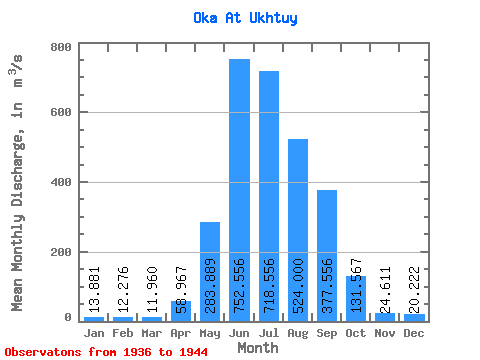
| Statistic | Jan | Feb | Mar | Apr | May | Jun | Jul | Aug | Sep | Oct | Nov | Dec | Annual |
|---|---|---|---|---|---|---|---|---|---|---|---|---|---|
| Mean | 13.88 | 12.28 | 11.96 | 58.97 | 283.89 | 752.56 | 718.56 | 524.00 | 377.56 | 131.57 | 24.61 | 20.22 | 244.17 |
| Standard Deviation | 7.09 | 6.52 | 6.37 | 44.31 | 96.84 | 180.08 | 178.37 | 130.40 | 169.33 | 49.47 | 14.95 | 10.34 | 35.77 |
| Min | 3.30 | 2.70 | 2.70 | 4.20 | 136.00 | 524.00 | 481.00 | 336.00 | 247.00 | 78.40 | 12.00 | 6.00 | 197.29 |
| Max | 22.40 | 20.40 | 20.00 | 118.00 | 398.00 | 1060.00 | 1000.00 | 768.00 | 800.00 | 232.00 | 53.30 | 33.60 | 290.44 |
| Coefficient of Variation | 0.51 | 0.53 | 0.53 | 0.75 | 0.34 | 0.24 | 0.25 | 0.25 | 0.45 | 0.38 | 0.61 | 0.51 | 0.15 |
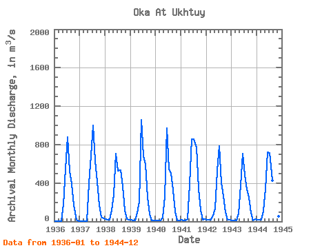
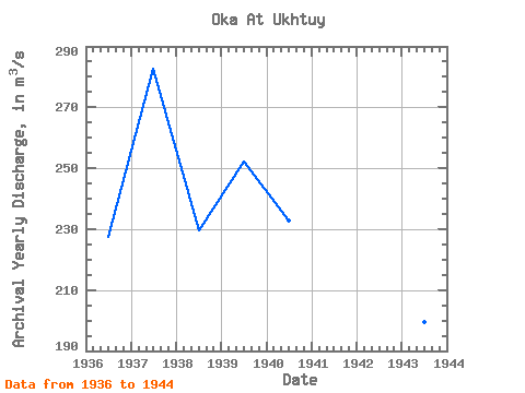
| Year | Jan | Feb | Mar | Apr | May | Jun | Jul | Aug | Sep | Oct | Nov | Dec | Annual | 1936 | 4.40 | 4.00 | 4.00 | 4.50 | 175.00 | 545.00 | 878.00 | 525.00 | 394.00 | 170.00 | 18.00 | 6.00 | 227.32 | 1937 | 3.30 | 2.70 | 2.70 | 4.20 | 398.00 | 686.00 | 1000.00 | 635.00 | 410.00 | 171.00 | 46.70 | 33.60 | 282.77 | 1938 | 22.40 | 20.40 | 20.00 | 118.00 | 279.00 | 708.00 | 527.00 | 534.00 | 365.00 | 119.00 | 23.20 | 17.20 | 229.43 | 1939 | 14.60 | 13.90 | 13.40 | 92.00 | 203.00 | 1060.00 | 685.00 | 589.00 | 255.00 | 78.40 | 12.00 | 9.60 | 252.16 | 1940 | 9.83 | 7.98 | 7.24 | 36.80 | 265.00 | 974.00 | 540.00 | 499.00 | 325.00 | 104.00 | 13.80 | 10.70 | 232.78 | 1941 | 15.00 | 12.00 | 12.00 | 23.00 | 380.00 | 855.00 | 859.00 | 768.00 | 339.00 | 117.00 | 20.40 | 28.50 | 285.74 | 1942 | 21.50 | 19.10 | 19.00 | 57.40 | 136.00 | 524.00 | 782.00 | 407.00 | 263.00 | 99.90 | 20.50 | 18.10 | 197.29 | 1943 | 12.90 | 11.40 | 11.30 | 82.80 | 378.00 | 703.00 | 481.00 | 336.00 | 247.00 | 92.80 | 13.60 | 25.30 | 199.59 | 1944 | 21.00 | 19.00 | 18.00 | 112.00 | 341.00 | 718.00 | 715.00 | 423.00 | 800.00 | 232.00 | 53.30 | 33.00 | 290.44 |
|---|
 Return to R-Arctic Net Home Page