|
|
|||||||||||||||||
| Point ID: 6314 | Downloads | Plots | Site Data | Code: 3554 |
|
|
|||||||||||||||||
| Download | |
|---|---|
| Site Descriptor Information | Site Time Series Data |
| Link to all available data | |
|
|
| View: | Statistics | Time Series |
| Units: | mm |
| Statistic | Jan | Feb | Mar | Apr | May | Jun | Jul | Aug | Sep | Oct | Nov | Dec | Annual |
|---|---|---|---|---|---|---|---|---|---|---|---|---|---|
| Mean | 31.04 | 26.12 | 24.83 | 39.59 | 441.06 | 592.50 | 288.13 | 187.84 | 184.33 | 116.97 | 57.23 | 38.24 | 162.43 |
| Standard Deviation | 22.62 | 18.43 | 17.52 | 37.04 | 236.08 | 374.74 | 176.94 | 127.68 | 112.03 | 64.29 | 28.35 | 23.28 | 84.92 |
| Min | 6.45 | 6.92 | 3.65 | 3.83 | 134.00 | 135.00 | 61.10 | 55.30 | 63.30 | 44.30 | 13.40 | 8.39 | 71.59 |
| Max | 81.50 | 58.50 | 62.70 | 166.00 | 1070.00 | 1520.00 | 649.00 | 431.00 | 435.00 | 268.00 | 108.00 | 88.50 | 335.62 |
| Coefficient of Variation | 0.73 | 0.70 | 0.71 | 0.94 | 0.54 | 0.63 | 0.61 | 0.68 | 0.61 | 0.55 | 0.49 | 0.61 | 0.52 |
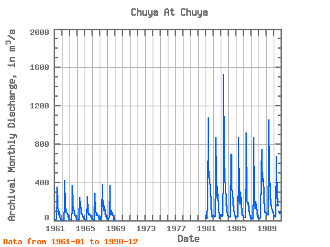
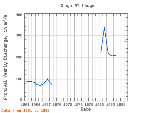
| Year | Jan | Feb | Mar | Apr | May | Jun | Jul | Aug | Sep | Oct | Nov | Dec | Annual | 1961 | 14.20 | 11.70 | 11.10 | 14.00 | 257.00 | 348.00 | 186.00 | 64.50 | 95.00 | 44.30 | 13.40 | 8.39 | 88.97 | 1962 | 6.45 | 6.92 | 5.75 | 5.96 | 160.00 | 417.00 | 147.00 | 90.90 | 81.50 | 71.80 | 48.00 | 16.30 | 88.13 | 1963 | 12.60 | 11.50 | 10.90 | 11.50 | 134.00 | 359.00 | 168.00 | 122.00 | 87.20 | 55.30 | 45.10 | 19.80 | 86.41 | 1964 | 12.30 | 9.03 | 7.33 | 11.40 | 240.00 | 169.00 | 195.00 | 71.70 | 78.50 | 46.40 | 29.20 | 21.10 | 74.25 | 1965 | 15.50 | 10.30 | 8.13 | 10.50 | 227.00 | 248.00 | 95.30 | 62.70 | 65.60 | 50.70 | 37.00 | 28.40 | 71.59 | 1966 | 19.60 | 11.30 | 3.65 | 3.83 | 285.00 | 268.00 | 115.00 | 55.30 | 71.90 | 57.20 | 44.00 | 16.30 | 79.26 | 1967 | 8.66 | 7.74 | 7.92 | 65.70 | 374.00 | 148.00 | 207.00 | 102.00 | 148.00 | 71.70 | 56.30 | 23.40 | 101.70 | 1968 | 17.40 | 15.10 | 12.00 | 38.40 | 360.00 | 135.00 | 61.10 | 104.00 | 63.30 | 75.10 | 22.30 | 14.00 | 76.47 | 1981 | 33.30 | 166.00 | 1070.00 | 569.00 | 458.00 | 426.00 | 324.00 | 177.00 | 45.10 | 41.70 | 1982 | 51.70 | 49.50 | 42.40 | 48.10 | 413.00 | 865.00 | 459.00 | 254.00 | 278.00 | 143.00 | 25.00 | 42.00 | 222.56 | 1983 | 57.40 | 57.90 | 45.10 | 51.00 | 502.00 | 1520.00 | 649.00 | 431.00 | 345.00 | 201.00 | 108.00 | 60.10 | 335.62 | 1984 | 43.00 | 36.30 | 39.50 | 42.50 | 689.00 | 683.00 | 362.00 | 272.00 | 215.00 | 103.00 | 73.20 | 39.80 | 216.53 | 1985 | 27.20 | 37.30 | 38.70 | 46.50 | 471.00 | 861.00 | 216.00 | 176.00 | 299.00 | 193.00 | 59.60 | 50.50 | 206.32 | 1986 | 40.50 | 31.70 | 30.70 | 35.60 | 626.00 | 916.00 | 203.00 | 184.00 | 191.00 | 120.00 | 62.00 | 46.70 | 207.27 | 1987 | 27.80 | 22.60 | 20.30 | 19.50 | 301.00 | 862.00 | 265.00 | 129.00 | 194.00 | 137.00 | 85.10 | 35.40 | 174.89 | 1988 | 21.60 | 18.50 | 25.30 | 35.60 | 505.00 | 742.00 | 608.00 | 409.00 | 435.00 | 268.00 | 89.00 | 87.80 | 270.40 | 1989 | 81.50 | 58.50 | 62.70 | 60.30 | 652.00 | 1050.00 | 499.00 | 268.00 | 177.00 | 135.00 | 108.00 | 88.50 | 270.04 | 1990 | 70.20 | 48.20 | 42.10 | 46.30 | 673.00 | 505.00 | 293.00 | 159.00 | 169.00 | 156.00 | 79.80 | 48.20 | 190.82 |
|---|
 Return to R-Arctic Net Home Page
