|
|
|||||||||||||||||
| Point ID: 6257 | Downloads | Plots | Site Data | Code: 3293 |
|
|
|||||||||||||||||
| Download | |
|---|---|
| Site Descriptor Information | Site Time Series Data |
| Link to all available data | |
|

|
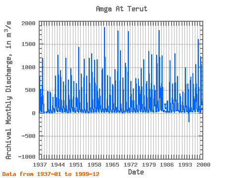
| View: | Statistics | Time Series |
| Units: | mm |
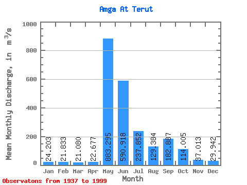
| Statistic | Jan | Feb | Mar | Apr | May | Jun | Jul | Aug | Sep | Oct | Nov | Dec | Annual |
|---|---|---|---|---|---|---|---|---|---|---|---|---|---|
| Mean | 24.20 | 21.83 | 21.08 | 22.68 | 883.29 | 590.92 | 237.85 | 129.38 | 182.89 | 114.00 | 37.01 | 29.94 | 191.42 |
| Standard Deviation | 10.95 | 10.03 | 9.92 | 10.36 | 412.82 | 268.81 | 183.59 | 83.53 | 155.96 | 81.96 | 21.67 | 14.35 | 61.19 |
| Min | 5.08 | 4.77 | 3.55 | 6.45 | 204.00 | 184.00 | 60.00 | 44.70 | -189.00 | 25.90 | 11.20 | 7.37 | 63.58 |
| Max | 66.20 | 60.90 | 55.60 | 68.20 | 1860.00 | 1190.00 | 1140.00 | 381.00 | 579.00 | 488.00 | 121.00 | 80.70 | 386.73 |
| Coefficient of Variation | 0.45 | 0.46 | 0.47 | 0.46 | 0.47 | 0.46 | 0.77 | 0.65 | 0.85 | 0.72 | 0.58 | 0.48 | 0.32 |
| Year | Jan | Feb | Mar | Apr | May | Jun | Jul | Aug | Sep | Oct | Nov | Dec | Annual | 1937 | 21.40 | 19.00 | 17.30 | 17.70 | 792.00 | 237.00 | 156.00 | 63.20 | 511.00 | 194.00 | 33.60 | 27.20 | 174.12 | 1938 | 26.20 | 24.70 | 22.30 | 27.10 | 1190.00 | 404.00 | 335.00 | 279.00 | 240.00 | 147.00 | 29.90 | 20.60 | 228.82 | 1940 | 19.80 | 19.40 | 18.80 | 17.60 | 466.00 | 451.00 | 90.50 | 73.90 | 67.80 | 52.80 | 15.50 | 10.50 | 108.63 | 1941 | 8.08 | 6.17 | 3.55 | 10.10 | 455.00 | 400.00 | 64.70 | 45.60 | 43.30 | 28.80 | 11.20 | 7.37 | 90.32 | 1942 | 5.08 | 4.77 | 3.58 | 6.45 | 320.00 | 334.00 | 92.00 | 64.90 | 104.00 | 65.00 | 24.90 | 19.30 | 87.00 | 1943 | 15.70 | 13.60 | 11.80 | 15.00 | 797.00 | 184.00 | 145.00 | 199.00 | 332.00 | 262.00 | 63.90 | 47.40 | 173.87 | 1944 | 39.90 | 34.90 | 28.90 | 25.70 | 1250.00 | 407.00 | 307.00 | 365.00 | 246.00 | 185.00 | 43.50 | 32.90 | 247.15 | 1945 | 27.80 | 30.00 | 31.70 | 34.20 | 918.00 | 626.00 | 454.00 | 100.00 | 86.00 | 80.40 | 24.90 | 17.10 | 202.51 | 1946 | 14.80 | 16.80 | 18.40 | 20.40 | 285.00 | 674.00 | 406.00 | 129.00 | 117.00 | 91.70 | 24.40 | 30.60 | 152.34 | 1947 | 29.30 | 25.00 | 22.20 | 20.30 | 1190.00 | 257.00 | 60.70 | 50.60 | 64.60 | 55.90 | 16.90 | 13.40 | 150.49 | 1948 | 10.90 | 8.33 | 6.66 | 10.80 | 719.00 | 273.00 | 73.70 | 381.00 | 192.00 | 124.00 | 32.70 | 20.40 | 154.37 | 1949 | 15.40 | 16.20 | 18.60 | 17.80 | 960.00 | 659.00 | 125.00 | 151.00 | 283.00 | 192.00 | 60.90 | 55.70 | 212.88 | 1950 | 43.50 | 32.10 | 27.20 | 25.80 | 680.00 | 410.00 | 113.00 | 93.70 | 70.40 | 37.00 | 12.70 | 12.20 | 129.80 | 1951 | 14.40 | 15.50 | 14.20 | 12.90 | 638.00 | 540.00 | 142.00 | 279.00 | 304.00 | 136.00 | 40.50 | 45.20 | 181.81 | 1952 | 33.50 | 23.00 | 17.80 | 18.10 | 1420.00 | 802.00 | 181.00 | 91.80 | 216.00 | 96.30 | 47.40 | 38.50 | 248.78 | 1953 | 25.70 | 22.00 | 22.60 | 20.60 | 843.00 | 269.00 | 89.20 | 60.10 | 61.40 | 62.80 | 25.00 | 21.20 | 126.88 | 1954 | 18.10 | 15.30 | 16.90 | 16.70 | 372.00 | 1170.00 | 95.30 | 56.00 | 55.20 | 32.80 | 12.70 | 9.62 | 155.88 | 1955 | 11.40 | 12.80 | 12.90 | 13.00 | 796.00 | 371.00 | 64.60 | 63.40 | 62.50 | 25.90 | 12.40 | 14.40 | 121.69 | 1956 | 10.50 | 10.70 | 10.80 | 12.10 | 219.00 | 1190.00 | 104.00 | 69.90 | 88.50 | 112.00 | 12.50 | 29.30 | 155.78 | 1957 | 21.70 | 14.80 | 14.00 | 15.40 | 1280.00 | 469.00 | 412.00 | 155.00 | 229.00 | 132.00 | 34.80 | 18.40 | 233.01 | 1958 | 13.90 | 14.60 | 15.10 | 14.30 | 698.00 | 830.00 | 1140.00 | 164.00 | 140.00 | 88.20 | 37.00 | 32.00 | 265.59 | 1959 | 31.10 | 25.70 | 23.00 | 21.10 | 1160.00 | 639.00 | 86.30 | 120.00 | 465.00 | 176.00 | 50.90 | 42.40 | 236.71 | 1960 | 30.80 | 27.90 | 24.70 | 21.10 | 521.00 | 493.00 | 235.00 | 100.00 | 155.00 | 93.80 | 34.10 | 29.20 | 147.13 | 1961 | 24.30 | 20.50 | 23.40 | 22.40 | 909.00 | 958.00 | 430.00 | 105.00 | 93.60 | 79.80 | 38.60 | 31.70 | 228.03 | 1962 | 22.60 | 19.30 | 17.00 | 16.80 | 1860.00 | 580.00 | 145.00 | 71.40 | 102.00 | 61.80 | 26.50 | 29.00 | 245.95 | 1963 | 24.70 | 21.60 | 22.10 | 22.80 | 568.00 | 812.00 | 241.00 | 57.40 | 52.10 | 39.40 | 22.60 | 23.70 | 158.95 | 1964 | 19.80 | 12.80 | 8.91 | 12.40 | 776.00 | 637.00 | 134.00 | 74.40 | 59.70 | 44.50 | 18.70 | 18.10 | 151.36 | 1965 | 15.00 | 11.80 | 13.40 | 14.70 | 619.00 | 553.00 | 191.00 | 105.00 | 194.00 | 110.00 | 32.90 | 24.80 | 157.05 | 1966 | 17.90 | 14.30 | 13.60 | 13.40 | 944.00 | 454.00 | 130.00 | 71.00 | 124.00 | 80.40 | 26.50 | 20.70 | 159.15 | 1967 | 18.00 | 19.40 | 22.50 | 24.90 | 1780.00 | 1040.00 | 61.90 | 47.80 | 50.10 | 36.40 | 19.30 | 21.80 | 261.84 | 1968 | 18.70 | 16.00 | 15.20 | 38.50 | 1350.00 | 300.00 | 87.90 | 46.60 | 74.70 | 88.40 | 26.60 | 21.40 | 173.67 | 1969 | 17.70 | 13.30 | 9.65 | 10.70 | 549.00 | 755.00 | 253.00 | 57.00 | 48.20 | 41.40 | 16.00 | 16.70 | 148.97 | 1970 | 15.30 | 12.00 | 13.80 | 22.30 | 1080.00 | 919.00 | 175.00 | 61.10 | 232.00 | 113.00 | 37.80 | 25.30 | 225.55 | 1971 | 21.40 | 20.50 | 21.70 | 19.80 | 1770.00 | 466.00 | 161.00 | 59.10 | 113.00 | 71.30 | 21.00 | 20.60 | 230.45 | 1972 | 16.10 | 14.70 | 15.90 | 21.00 | 686.00 | 535.00 | 269.00 | 136.00 | 261.00 | 144.00 | 37.80 | 28.80 | 180.44 | 1973 | 23.60 | 18.30 | 18.50 | 27.20 | 521.00 | 292.00 | 243.00 | 147.00 | 65.50 | 88.20 | 32.90 | 23.70 | 125.08 | 1974 | 13.30 | 13.40 | 14.90 | 15.70 | 750.00 | 514.00 | 256.00 | 95.30 | 119.00 | 97.00 | 28.30 | 30.60 | 162.29 | 1975 | 25.30 | 21.80 | 17.20 | 22.30 | 737.00 | 318.00 | 209.00 | 184.00 | 571.00 | 244.00 | 65.70 | 42.10 | 204.78 | 1976 | 35.00 | 26.60 | 23.90 | 27.60 | 958.00 | 753.00 | 385.00 | 90.20 | 278.00 | 106.00 | 42.00 | 29.50 | 229.57 | 1977 | 21.50 | 23.30 | 22.50 | 24.00 | 1160.00 | 550.00 | 186.00 | 95.70 | 129.00 | 91.00 | 34.80 | 35.30 | 197.76 | 1978 | 23.50 | 20.50 | 20.80 | 25.50 | 590.00 | 683.00 | 542.00 | 108.00 | 136.00 | 82.30 | 34.40 | 21.50 | 190.62 | 1979 | 17.10 | 16.90 | 16.30 | 19.10 | 1340.00 | 349.00 | 101.00 | 282.00 | 508.00 | 176.00 | 77.70 | 56.90 | 246.67 | 1980 | 37.30 | 31.60 | 27.30 | 22.80 | 1260.00 | 711.00 | 298.00 | 81.40 | 62.30 | 50.70 | 21.70 | 23.50 | 218.97 | 1981 | 23.40 | 23.70 | 22.70 | 21.30 | 597.00 | 234.00 | 180.00 | 161.00 | 493.00 | 292.00 | 66.60 | 44.40 | 179.93 | 1982 | 27.20 | 22.80 | 21.70 | 29.00 | 1250.00 | 903.00 | 772.00 | 207.00 | 250.00 | 148.00 | 59.90 | 41.20 | 310.98 | 1983 | 36.70 | 38.40 | 46.80 | 68.20 | 1790.00 | 625.00 | 424.00 | 343.00 | 579.00 | 488.00 | 121.00 | 80.70 | 386.73 | 1984 | 66.20 | 60.90 | 53.70 | 46.50 | 1240.00 | 1010.00 | 114.00 | 81.40 | 68.40 | 58.70 | 41.10 | 36.10 | 239.75 | 1985 | 29.90 | 25.40 | 26.50 | 45.50 | 190.00 | 114.00 | 106.00 | 21.80 | 26.90 | 1986 | 20.40 | 16.90 | 15.20 | 15.40 | 219.00 | 260.00 | 60.00 | 44.70 | 42.60 | 36.20 | 17.00 | 15.50 | 63.58 | 1987 | 14.50 | 13.80 | 14.00 | 15.00 | 204.00 | 1130.00 | 282.00 | 131.00 | 72.60 | 50.40 | 23.10 | 19.80 | 164.18 | 1988 | 22.30 | 29.50 | 22.70 | 23.90 | 628.00 | 386.00 | 303.00 | 269.00 | 263.00 | 150.00 | 50.70 | 37.00 | 182.09 | 1989 | 27.50 | 22.00 | 17.40 | 16.40 | 1290.00 | 842.00 | 466.00 | 263.00 | 283.00 | 140.00 | 53.20 | 60.20 | 290.06 | 1990 | 57.70 | 55.60 | 55.60 | 46.20 | 794.00 | 255.00 | 171.00 | 70.90 | 57.10 | 45.10 | 25.90 | 23.00 | 138.09 | 1991 | 19.50 | 14.90 | 12.30 | 16.20 | 412.00 | 295.00 | 211.00 | 111.00 | 166.00 | 44.00 | 20.70 | 26.30 | 112.41 | 1992 | 26.70 | 28.30 | 28.40 | 25.80 | 460.00 | 362.00 | 189.00 | 133.00 | 85.50 | 77.00 | 31.20 | 16.50 | 121.95 | 1993 | 16.30 | 19.90 | 22.60 | 19.80 | 833.00 | 989.00 | 255.00 | 127.00 | 157.00 | 118.00 | 35.40 | 33.80 | 218.90 | 1994 | 32.20 | 33.60 | 33.00 | 31.50 | 633.00 | 605.00 | 426.00 | 153.00 | -189.00 | 116.00 | 32.50 | 26.30 | 161.09 | 1995 | 27.20 | 31.50 | 33.10 | 32.10 | 630.00 | 783.00 | 133.00 | 98.70 | 81.90 | 62.90 | 25.50 | 31.70 | 164.22 | 1996 | 27.10 | 26.80 | 24.80 | 21.90 | 855.00 | 395.00 | 214.00 | 70.70 | 350.00 | 254.00 | 77.30 | 53.70 | 197.53 | 1997 | 41.40 | 32.10 | 32.10 | 33.70 | 1050.00 | 833.00 | 438.00 | 249.00 | 523.00 | 301.00 | 100.00 | 65.80 | 308.26 | 1998 | 39.80 | 34.90 | 34.10 | 31.30 | 1600.00 | 982.00 | 122.00 | 72.90 | 150.00 | 103.00 | 52.40 | 34.60 | 271.42 | 1999 | 27.50 | 20.80 | 28.70 | 28.10 | 1220.00 | 889.00 | 326.00 | 191.00 | 393.00 | 153.00 | 75.40 | 42.30 | 282.90 |
|---|
 Return to R-Arctic Net Home Page