|
|
|||||||||||||||||
| Point ID: 6231 | Downloads | Plots | Site Data | Code: 3218 |
|
|
|||||||||||||||||
| Download | |
|---|---|
| Site Descriptor Information | Site Time Series Data |
| Link to all available data | |
|
|
| View: | Statistics | Time Series |
| Units: | mm |
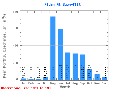
| Statistic | Jan | Feb | Mar | Apr | May | Jun | Jul | Aug | Sep | Oct | Nov | Dec | Annual |
|---|---|---|---|---|---|---|---|---|---|---|---|---|---|
| Mean | 21.04 | 16.91 | 15.96 | 35.77 | 732.45 | 593.06 | 320.98 | 309.04 | 298.10 | 129.88 | 73.10 | 36.96 | 215.26 |
| Standard Deviation | 9.55 | 8.12 | 9.30 | 37.76 | 196.19 | 252.14 | 170.17 | 150.97 | 125.69 | 49.20 | 40.94 | 19.43 | 43.25 |
| Min | 7.26 | 1.52 | 1.07 | 6.97 | 296.00 | 270.00 | 93.90 | 91.80 | 108.00 | 32.20 | 26.10 | 11.40 | 111.60 |
| Max | 47.20 | 41.30 | 49.60 | 192.00 | 1220.00 | 1300.00 | 1040.00 | 631.00 | 588.00 | 260.00 | 192.00 | 93.90 | 327.72 |
| Coefficient of Variation | 0.45 | 0.48 | 0.58 | 1.06 | 0.27 | 0.42 | 0.53 | 0.49 | 0.42 | 0.38 | 0.56 | 0.53 | 0.20 |
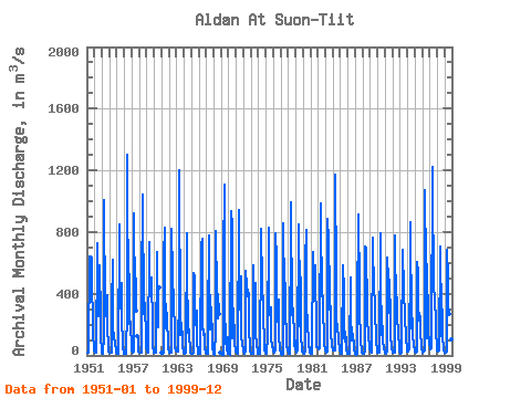
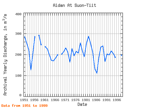
| Year | Jan | Feb | Mar | Apr | May | Jun | Jul | Aug | Sep | Oct | Nov | Dec | Annual | 1951 | 16.00 | 18.40 | 14.50 | 22.40 | 640.00 | 640.00 | 574.00 | 631.00 | 497.00 | 190.00 | 121.00 | 63.20 | 285.62 | 1952 | 30.40 | 21.10 | 19.60 | 35.00 | 678.00 | 725.00 | 253.00 | 309.00 | 582.00 | 244.00 | 124.00 | 33.50 | 254.55 | 1953 | 21.10 | 19.60 | 11.20 | 129.00 | 1008.00 | 273.00 | 293.00 | 254.00 | 391.00 | 169.00 | 72.00 | 27.30 | 222.35 | 1954 | 18.90 | 17.70 | 14.90 | 18.40 | 307.00 | 621.00 | 151.00 | 137.00 | 110.00 | 79.80 | 28.40 | 16.90 | 126.75 | 1955 | 13.70 | 13.60 | 7.72 | 9.98 | 852.00 | 304.00 | 318.00 | 467.00 | 222.00 | 99.90 | 52.40 | 19.30 | 198.30 | 1956 | 12.30 | 10.30 | 9.04 | 10.40 | 296.00 | 1300.00 | 206.00 | 619.00 | 438.00 | 248.00 | 192.00 | 68.70 | 284.14 | 1957 | 30.50 | 24.00 | 20.70 | 26.70 | 919.00 | 355.00 | 501.00 | 287.00 | 123.00 | 97.30 | 26.30 | 1958 | 17.80 | 16.10 | 14.90 | 18.10 | 733.00 | 465.00 | 1040.00 | 270.00 | 429.00 | 260.00 | 185.00 | 59.70 | 292.38 | 1959 | 27.10 | 26.00 | 21.10 | 28.10 | 736.00 | 460.00 | 427.00 | 478.00 | 507.00 | 178.00 | 52.30 | 25.10 | 247.14 | 1960 | 15.10 | 14.70 | 15.50 | 21.30 | 672.00 | 513.00 | 183.00 | 409.00 | 442.00 | 1961 | 17.60 | 15.10 | 13.60 | 18.20 | 649.00 | 830.00 | 488.00 | 177.00 | 279.00 | 161.00 | 156.00 | 48.10 | 237.72 | 1962 | 27.50 | 20.70 | 16.80 | 18.40 | 821.00 | 526.00 | 290.00 | 426.00 | 334.00 | 167.00 | 44.20 | 29.10 | 226.72 | 1963 | 26.30 | 26.20 | 28.10 | 30.00 | 418.00 | 1200.00 | 179.00 | 135.00 | 209.00 | 97.50 | 53.40 | 21.70 | 202.02 | 1964 | 16.90 | 16.30 | 12.60 | 16.60 | 790.00 | 459.00 | 258.00 | 144.00 | 170.00 | 116.00 | 54.40 | 17.80 | 172.63 | 1965 | 12.60 | 10.10 | 9.72 | 14.50 | 534.00 | 513.00 | 331.00 | 194.00 | 291.00 | 84.80 | 35.20 | 14.10 | 170.34 | 1966 | 9.74 | 8.89 | 10.90 | 17.10 | 719.00 | 757.00 | 197.00 | 133.00 | 167.00 | 108.00 | 49.40 | 21.20 | 183.19 | 1967 | 14.90 | 11.30 | 10.70 | 192.00 | 781.00 | 315.00 | 165.00 | 394.00 | 242.00 | 178.00 | 51.80 | 18.80 | 197.88 | 1968 | 10.20 | 6.07 | 3.70 | 158.00 | 808.00 | 407.00 | 240.00 | 400.00 | 268.00 | 15.80 | 1969 | 7.26 | 1.52 | 1.07 | 6.97 | 634.00 | 1110.00 | 299.00 | 108.00 | 108.00 | 32.20 | 120.00 | 11.40 | 203.28 | 1970 | 8.67 | 8.33 | 6.91 | 14.30 | 934.00 | 840.00 | 113.00 | 138.00 | 307.00 | 87.50 | 69.50 | 47.70 | 214.58 | 1971 | 23.60 | 14.50 | 9.26 | 11.90 | 940.00 | 352.00 | 300.00 | 358.00 | 512.00 | 136.00 | 65.80 | 48.10 | 230.93 | 1972 | 29.10 | 12.60 | 14.60 | 26.50 | 546.00 | 457.00 | 382.00 | 429.00 | 381.00 | 169.00 | 56.40 | 31.10 | 211.19 | 1973 | 14.00 | 8.01 | 10.70 | 13.90 | 581.00 | 325.00 | 298.00 | 473.00 | 136.00 | 73.40 | 26.10 | 12.30 | 164.28 | 1974 | 10.10 | 7.46 | 9.08 | 19.80 | 692.00 | 821.00 | 453.00 | 318.00 | 265.00 | 78.20 | 33.30 | 37.10 | 228.67 | 1975 | 16.30 | 12.30 | 16.10 | 123.00 | 830.00 | 270.00 | 267.00 | 265.00 | 314.00 | 121.00 | 56.30 | 37.60 | 194.05 | 1976 | 25.90 | 21.50 | 18.90 | 37.20 | 792.00 | 622.00 | 220.00 | 277.00 | 359.00 | 117.00 | 56.30 | 34.30 | 215.09 | 1977 | 14.70 | 8.38 | 6.39 | 12.80 | 859.00 | 407.00 | 201.00 | 471.00 | 309.00 | 98.90 | 62.70 | 31.80 | 206.89 | 1978 | 22.50 | 13.20 | 12.50 | 27.20 | 864.00 | 991.00 | 262.00 | 306.00 | 292.00 | 126.00 | 63.40 | 93.90 | 256.14 | 1979 | 44.40 | 16.50 | 15.10 | 42.90 | 850.00 | 276.00 | 187.00 | 611.00 | 404.00 | 142.00 | 26.10 | 22.50 | 219.79 | 1980 | 14.80 | 13.20 | 13.70 | 21.90 | 618.00 | 815.00 | 362.00 | 168.00 | 130.00 | 67.70 | 35.60 | 18.10 | 189.83 | 1981 | 15.10 | 14.30 | 9.49 | 19.20 | 670.00 | 486.00 | 443.00 | 581.00 | 504.00 | 190.00 | 55.40 | 54.30 | 253.48 | 1982 | 47.20 | 41.30 | 48.30 | 65.30 | 989.00 | 894.00 | 381.00 | 447.00 | 322.00 | 94.40 | 69.70 | 44.00 | 286.93 | 1983 | 29.80 | 24.90 | 20.80 | 25.50 | 884.00 | 742.00 | 419.00 | 297.00 | 320.00 | 145.00 | 67.30 | 64.80 | 253.34 | 1984 | 32.10 | 34.90 | 32.40 | 33.00 | 1170.00 | 501.00 | 259.00 | 156.00 | 139.00 | 78.70 | 58.20 | 39.90 | 211.18 | 1985 | 19.30 | 11.10 | 9.28 | 34.30 | 586.00 | 421.00 | 119.00 | 91.80 | 153.00 | 88.00 | 42.20 | 20.20 | 132.93 | 1986 | 13.10 | 10.50 | 9.61 | 13.50 | 505.00 | 274.00 | 93.90 | 176.00 | 113.00 | 81.30 | 29.70 | 19.60 | 111.60 | 1987 | 9.55 | 7.38 | 6.02 | 9.35 | 297.00 | 911.00 | 420.00 | 221.00 | 175.00 | 86.50 | 29.80 | 16.20 | 182.40 | 1988 | 12.60 | 11.30 | 9.35 | 29.90 | 706.00 | 691.00 | 396.00 | 489.00 | 261.00 | 107.00 | 76.10 | 43.80 | 236.09 | 1989 | 28.00 | 23.70 | 21.10 | 32.70 | 764.00 | 739.00 | 402.00 | 365.00 | 245.00 | 147.00 | 83.70 | 47.80 | 241.58 | 1990 | 21.20 | 17.30 | 20.00 | 36.10 | 789.00 | 337.00 | 297.00 | 135.00 | 192.00 | 92.50 | 45.10 | 27.10 | 167.44 | 1991 | 15.60 | 14.40 | 14.00 | 24.00 | 636.00 | 492.00 | 278.00 | 493.00 | 233.00 | 112.00 | 76.50 | 39.00 | 202.29 | 1992 | 22.70 | 21.10 | 18.00 | 21.10 | 781.00 | 272.00 | 473.00 | 290.00 | 267.00 | 126.00 | 65.50 | 27.50 | 198.74 | 1993 | 12.20 | 13.90 | 15.80 | 32.70 | 687.00 | 636.00 | 465.00 | 210.00 | 270.00 | 107.00 | 111.00 | 47.90 | 217.38 | 1994 | 28.10 | 25.30 | 23.50 | 37.00 | 634.00 | 866.00 | 174.00 | 204.00 | 239.00 | 123.00 | 66.00 | 34.90 | 204.57 | 1995 | 26.30 | 22.50 | 20.80 | 28.10 | 608.00 | 539.00 | 226.00 | 279.00 | 238.00 | 122.00 | 80.40 | 47.20 | 186.44 | 1996 | 26.40 | 19.30 | 22.00 | 31.40 | 1070.00 | 573.00 | 121.00 | 113.00 | 588.00 | 195.00 | 163.00 | 78.10 | 250.02 | 1997 | 46.10 | 38.40 | 49.60 | 79.60 | 1220.00 | 530.00 | 779.00 | 410.00 | 402.00 | 173.00 | 126.00 | 78.90 | 327.72 | 1998 | 34.00 | 26.80 | 25.40 | 33.60 | 707.00 | 705.00 | 221.00 | 127.00 | 297.00 | 121.00 | 44.80 | 30.60 | 197.77 | 1999 | 21.50 | 16.60 | 17.20 | 23.80 | 686.00 | 502.00 | 323.00 | 272.00 | 256.00 | 162.00 | 105.00 | 59.90 | 203.75 |
|---|
 Return to R-Arctic Net Home Page