|
|
|||||||||||||||||
| Point ID: 6205 | Downloads | Plots | Site Data | Code: 3152 |
|
|
|||||||||||||||||
| Download | |
|---|---|
| Site Descriptor Information | Site Time Series Data |
| Link to all available data | |
|

|
| View: | Statistics | Time Series |
| Units: | mm |
| Statistic | Jan | Feb | Mar | Apr | May | Jun | Jul | Aug | Sep | Oct | Nov | Dec | Annual |
|---|---|---|---|---|---|---|---|---|---|---|---|---|---|
| Mean | 14.32 | 10.66 | 8.81 | 10.17 | 111.45 | 436.97 | 250.56 | 180.08 | 152.43 | 80.72 | 33.59 | 21.81 | 109.59 |
| Standard Deviation | 4.05 | 3.34 | 2.77 | 3.13 | 44.92 | 88.69 | 90.48 | 62.82 | 50.51 | 18.09 | 10.85 | 6.63 | 17.39 |
| Min | 8.88 | 3.85 | 3.87 | 4.92 | 23.80 | 314.00 | 115.00 | 91.10 | 79.40 | 48.50 | 15.60 | 8.29 | 76.02 |
| Max | 25.10 | 18.80 | 16.00 | 18.90 | 215.00 | 667.00 | 410.00 | 365.00 | 303.00 | 114.00 | 63.70 | 38.00 | 141.85 |
| Coefficient of Variation | 0.28 | 0.31 | 0.31 | 0.31 | 0.40 | 0.20 | 0.36 | 0.35 | 0.33 | 0.22 | 0.32 | 0.30 | 0.16 |
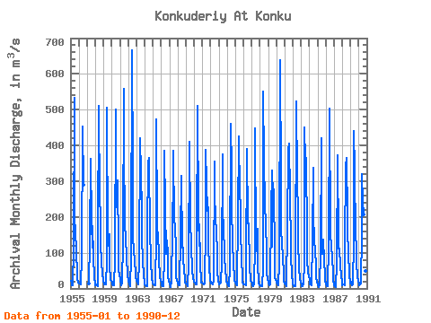
| Year | Jan | Feb | Mar | Apr | May | Jun | Jul | Aug | Sep | Oct | Nov | Dec | Annual | 1955 | 20.70 | 18.80 | 8.87 | 8.01 | 116.00 | 532.00 | 186.00 | 170.00 | 94.80 | 48.50 | 28.80 | 17.50 | 104.17 | 1956 | 12.60 | 14.80 | 13.50 | 10.50 | 87.30 | 454.00 | 290.00 | 1957 | 13.10 | 132.00 | 363.00 | 185.00 | 115.00 | 174.00 | 92.60 | 25.10 | 17.40 | 1958 | 9.39 | 12.20 | 9.47 | 5.48 | 148.00 | 511.00 | 243.00 | 212.00 | 125.00 | 73.20 | 37.80 | 24.90 | 117.62 | 1959 | 10.80 | 12.80 | 12.20 | 12.30 | 79.90 | 505.00 | 119.00 | 149.00 | 152.00 | 66.90 | 22.90 | 20.10 | 96.91 | 1960 | 16.10 | 11.80 | 8.14 | 8.08 | 82.70 | 501.00 | 226.00 | 298.00 | 303.00 | 110.00 | 51.80 | 38.00 | 137.88 | 1961 | 25.10 | 9.27 | 7.59 | 12.70 | 132.00 | 558.00 | 410.00 | 168.00 | 153.00 | 79.70 | 42.80 | 35.50 | 136.14 | 1962 | 21.40 | 11.80 | 8.26 | 6.87 | 88.00 | 667.00 | 321.00 | 135.00 | 115.00 | 69.70 | 47.90 | 31.40 | 126.94 | 1963 | 20.30 | 15.30 | 12.40 | 12.20 | 76.70 | 419.00 | 320.00 | 221.00 | 142.00 | 78.20 | 34.60 | 22.20 | 114.49 | 1964 | 12.00 | 7.85 | 5.98 | 7.40 | 161.00 | 349.00 | 364.00 | 139.00 | 167.00 | 76.00 | 29.80 | 13.10 | 111.01 | 1965 | 12.10 | 11.20 | 9.65 | 9.33 | 150.00 | 474.00 | 189.00 | 127.00 | 118.00 | 81.10 | 31.60 | 23.70 | 103.06 | 1966 | 13.00 | 8.84 | 5.09 | 6.22 | 90.30 | 386.00 | 228.00 | 97.30 | 135.00 | 96.20 | 34.00 | 17.90 | 93.15 | 1967 | 13.00 | 6.46 | 4.00 | 18.90 | 161.00 | 318.00 | 386.00 | 185.00 | 182.00 | 104.00 | 31.10 | 24.70 | 119.51 | 1968 | 16.00 | 9.69 | 8.64 | 9.73 | 145.00 | 314.00 | 115.00 | 152.00 | 79.40 | 56.90 | 20.50 | 15.70 | 78.55 | 1969 | 13.00 | 10.30 | 7.76 | 6.99 | 66.50 | 411.00 | 181.00 | 128.00 | 113.00 | 54.80 | 26.30 | 22.60 | 86.77 | 1970 | 19.00 | 15.60 | 12.20 | 11.40 | 124.00 | 510.00 | 199.00 | 119.00 | 179.00 | 74.90 | 17.20 | 16.40 | 108.14 | 1971 | 14.50 | 13.40 | 10.60 | 13.40 | 173.00 | 388.00 | 295.00 | 218.00 | 226.00 | 114.00 | 63.70 | 21.10 | 129.22 | 1972 | 16.40 | 14.40 | 13.00 | 11.10 | 23.80 | 356.00 | 273.00 | 190.00 | 167.00 | 92.20 | 47.90 | 20.50 | 102.11 | 1973 | 12.50 | 14.00 | 16.00 | 15.80 | 73.80 | 375.00 | 204.00 | 182.00 | 86.90 | 53.00 | 24.50 | 21.70 | 89.93 | 1974 | 14.10 | 8.69 | 7.22 | 7.71 | 54.40 | 461.00 | 331.00 | 224.00 | 129.00 | 70.70 | 28.20 | 22.50 | 113.21 | 1975 | 15.70 | 10.30 | 8.70 | 15.50 | 195.00 | 426.00 | 259.00 | 234.00 | 153.00 | 93.70 | 18.20 | 11.60 | 120.06 | 1976 | 12.30 | 11.30 | 10.50 | 9.19 | 56.80 | 389.00 | 181.00 | 178.00 | 181.00 | 62.90 | 21.50 | 19.60 | 94.42 | 1977 | 15.50 | 9.56 | 5.24 | 10.30 | 125.00 | 447.00 | 117.00 | 105.00 | 166.00 | 68.80 | 15.60 | 8.29 | 91.11 | 1978 | 9.53 | 8.08 | 6.38 | 6.02 | 59.80 | 551.00 | 356.00 | 243.00 | 173.00 | 112.00 | 42.30 | 27.70 | 132.90 | 1979 | 14.40 | 7.92 | 8.73 | 11.60 | 215.00 | 331.00 | 117.00 | 294.00 | 262.00 | 106.00 | 29.90 | 25.40 | 118.58 | 1980 | 16.20 | 12.10 | 9.84 | 10.60 | 66.00 | 638.00 | 294.00 | 162.00 | 127.00 | 89.90 | 38.20 | 21.70 | 123.80 | 1981 | 14.00 | 11.60 | 6.95 | 12.30 | 167.00 | 388.00 | 406.00 | 261.00 | 278.00 | 102.00 | 28.60 | 26.80 | 141.85 | 1982 | 12.80 | 6.82 | 5.61 | 6.24 | 57.00 | 522.00 | 306.00 | 207.00 | 129.00 | 62.40 | 24.70 | 18.40 | 113.16 | 1983 | 10.20 | 7.11 | 7.24 | 12.10 | 71.90 | 451.00 | 356.00 | 365.00 | 148.00 | 82.20 | 44.70 | 37.50 | 132.75 | 1984 | 21.50 | 12.00 | 10.20 | 9.05 | 134.00 | 338.00 | 207.00 | 132.00 | 109.00 | 61.20 | 30.10 | 18.80 | 90.24 | 1985 | 8.88 | 3.85 | 7.33 | 9.08 | 101.00 | 420.00 | 141.00 | 96.40 | 136.00 | 79.40 | 36.40 | 22.80 | 88.51 | 1986 | 10.10 | 5.79 | 6.64 | 9.44 | 120.00 | 502.00 | 151.00 | 147.00 | 121.00 | 83.30 | 42.80 | 23.40 | 101.87 | 1987 | 9.01 | 5.43 | 3.87 | 4.92 | 72.20 | 372.00 | 126.00 | 91.10 | 111.00 | 62.90 | 36.40 | 17.40 | 76.02 | 1988 | 9.72 | 10.40 | 10.30 | 8.51 | 117.00 | 343.00 | 366.00 | 203.00 | 159.00 | 99.50 | 40.60 | 13.40 | 115.04 | 1989 | 18.00 | 15.20 | 9.81 | 10.70 | 132.00 | 441.00 | 329.00 | 147.00 | 117.00 | 70.40 | 31.20 | 20.20 | 111.79 | 1990 | 11.30 | 8.35 | 10.40 | 13.40 | 157.00 | 320.00 | 243.00 | 208.00 | 124.00 | 96.10 | 47.80 | 23.60 | 105.25 |
|---|
 Return to R-Arctic Net Home Page
