|
|
|||||||||||||||||
| Point ID: 6203 | Downloads | Plots | Site Data | Code: 3150 |
|
|
|||||||||||||||||
| Download | |
|---|---|
| Site Descriptor Information | Site Time Series Data |
| Link to all available data | |
|
|
| View: | Statistics | Time Series |
| Units: | mm |
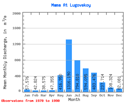
| Statistic | Jan | Feb | Mar | Apr | May | Jun | Jul | Aug | Sep | Oct | Nov | Dec | Annual |
|---|---|---|---|---|---|---|---|---|---|---|---|---|---|
| Mean | 57.58 | 42.82 | 38.58 | 47.35 | 416.95 | 1316.19 | 794.81 | 594.10 | 483.48 | 237.71 | 108.32 | 82.08 | 353.71 |
| Standard Deviation | 14.99 | 9.99 | 7.66 | 16.94 | 148.98 | 249.59 | 297.07 | 201.63 | 147.22 | 61.68 | 35.28 | 22.56 | 56.49 |
| Min | 33.40 | 24.60 | 27.50 | 30.00 | 220.00 | 1000.00 | 341.00 | 280.00 | 278.00 | 139.00 | 68.90 | 44.40 | 247.38 |
| Max | 105.00 | 59.10 | 55.50 | 103.00 | 733.00 | 1980.00 | 1350.00 | 1110.00 | 863.00 | 369.00 | 195.00 | 150.00 | 446.19 |
| Coefficient of Variation | 0.26 | 0.23 | 0.20 | 0.36 | 0.36 | 0.19 | 0.37 | 0.34 | 0.30 | 0.26 | 0.33 | 0.28 | 0.16 |
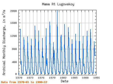
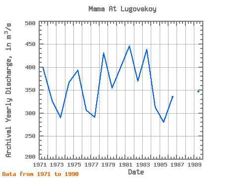
| Year | Jan | Feb | Mar | Apr | May | Jun | Jul | Aug | Sep | Oct | Nov | Dec | Annual | 1970 | 55.20 | 40.40 | 1400.00 | 604.00 | 336.00 | 416.00 | 219.00 | 93.80 | 61.00 | 1971 | 53.40 | 32.30 | 27.50 | 40.50 | 516.00 | 1160.00 | 851.00 | 722.00 | 695.00 | 319.00 | 195.00 | 150.00 | 396.81 | 1972 | 105.00 | 48.50 | 39.60 | 48.00 | 220.00 | 1180.00 | 795.00 | 503.00 | 521.00 | 265.00 | 138.00 | 66.00 | 327.43 | 1973 | 39.90 | 29.80 | 33.50 | 47.60 | 310.00 | 1110.00 | 682.00 | 648.00 | 278.00 | 178.00 | 78.30 | 44.40 | 289.96 | 1974 | 33.40 | 24.60 | 28.70 | 30.60 | 267.00 | 1510.00 | 970.00 | 655.00 | 451.00 | 208.00 | 119.00 | 89.80 | 365.59 | 1975 | 48.60 | 32.40 | 30.20 | 46.40 | 653.00 | 1360.00 | 765.00 | 763.00 | 484.00 | 277.00 | 153.00 | 107.00 | 393.30 | 1976 | 65.60 | 50.30 | 38.30 | 39.80 | 307.00 | 1130.00 | 539.00 | 580.00 | 512.00 | 187.00 | 127.00 | 92.40 | 305.70 | 1977 | 43.70 | 31.00 | 32.10 | 30.00 | 409.00 | 1430.00 | 374.00 | 282.00 | 506.00 | 197.00 | 91.80 | 66.90 | 291.12 | 1978 | 47.30 | 34.40 | 30.30 | 36.50 | 323.00 | 1630.00 | 1170.00 | 755.00 | 560.00 | 369.00 | 128.00 | 85.00 | 430.71 | 1979 | 64.20 | 51.30 | 36.90 | 38.10 | 733.00 | 1000.00 | 341.00 | 766.00 | 699.00 | 309.00 | 123.00 | 86.90 | 354.03 | 1980 | 48.30 | 32.60 | 35.80 | 41.70 | 247.00 | 1980.00 | 977.00 | 534.00 | 415.00 | 271.00 | 86.70 | 113.00 | 398.51 | 1981 | 81.10 | 59.10 | 37.10 | 103.00 | 600.00 | 1140.00 | 1230.00 | 760.00 | 863.00 | 285.00 | 102.00 | 94.00 | 446.19 | 1982 | 66.20 | 51.20 | 40.70 | 63.10 | 307.00 | 1560.00 | 875.00 | 649.00 | 394.00 | 168.00 | 179.00 | 85.30 | 369.88 | 1983 | 51.00 | 41.70 | 40.50 | 30.20 | 336.00 | 1460.00 | 1170.00 | 1110.00 | 558.00 | 273.00 | 104.00 | 88.20 | 438.55 | 1984 | 64.70 | 58.80 | 47.80 | 41.30 | 522.00 | 1090.00 | 814.00 | 469.00 | 342.00 | 139.00 | 88.00 | 74.60 | 312.60 | 1985 | 59.70 | 48.40 | 46.30 | 52.20 | 372.00 | 1260.00 | 450.00 | 316.00 | 401.00 | 193.00 | 73.70 | 82.60 | 279.57 | 1986 | 53.20 | 42.60 | 43.30 | 46.90 | 480.00 | 1590.00 | 483.00 | 508.00 | 383.00 | 231.00 | 82.20 | 71.50 | 334.56 | 1987 | 56.90 | 42.20 | 36.10 | 38.00 | 261.00 | 1190.00 | 418.00 | 280.00 | 339.00 | 170.00 | 75.40 | 62.00 | 247.38 | 1988 | 55.90 | 48.10 | 55.50 | 72.70 | 413.00 | 1030.00 | 1350.00 | 746.00 | 643.00 | 311.00 | 98.40 | 73.90 | 408.12 | 1989 | 57.20 | 45.10 | 38.40 | 43.80 | 448.00 | 1400.00 | 1030.00 | 489.00 | 309.00 | 171.00 | 68.90 | 65.20 | 347.13 | 1990 | 58.60 | 54.50 | 52.90 | 56.70 | 615.00 | 1030.00 | 803.00 | 605.00 | 384.00 | 252.00 | 69.60 | 64.00 | 337.11 |
|---|
 Return to R-Arctic Net Home Page