|
|
|||||||||||||||||
| Point ID: 6196 | Downloads | Plots | Site Data | Code: 3135 |
|
|
|||||||||||||||||
| Download | |
|---|---|
| Site Descriptor Information | Site Time Series Data |
| Link to all available data | |

|
|
| View: | Statistics | Time Series |
| Units: | mm |
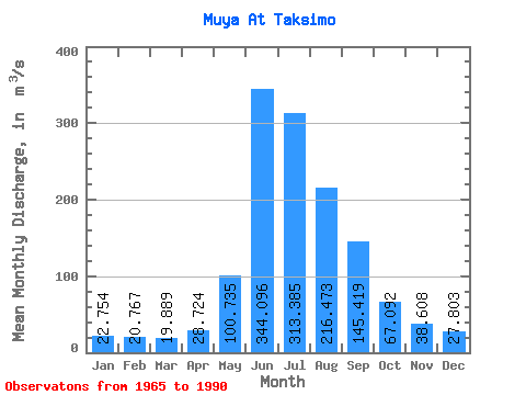
| Statistic | Jan | Feb | Mar | Apr | May | Jun | Jul | Aug | Sep | Oct | Nov | Dec | Annual |
|---|---|---|---|---|---|---|---|---|---|---|---|---|---|
| Mean | 22.75 | 20.77 | 19.89 | 28.72 | 100.73 | 344.10 | 313.38 | 216.47 | 145.42 | 67.09 | 38.61 | 27.80 | 112.64 |
| Standard Deviation | 6.83 | 7.62 | 6.65 | 8.23 | 58.22 | 119.45 | 163.97 | 77.87 | 48.49 | 16.87 | 10.68 | 6.71 | 28.36 |
| Min | 7.10 | 3.66 | 4.11 | 12.20 | 28.70 | 48.50 | 52.80 | 52.50 | 33.90 | 26.10 | 14.70 | 9.49 | 27.86 |
| Max | 37.90 | 40.00 | 37.00 | 46.30 | 309.00 | 552.00 | 626.00 | 359.00 | 246.00 | 99.60 | 62.70 | 37.00 | 160.03 |
| Coefficient of Variation | 0.30 | 0.37 | 0.33 | 0.29 | 0.58 | 0.35 | 0.52 | 0.36 | 0.33 | 0.25 | 0.28 | 0.24 | 0.25 |
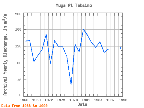
| Year | Jan | Feb | Mar | Apr | May | Jun | Jul | Aug | Sep | Oct | Nov | Dec | Annual | 1965 | 22.20 | 109.00 | 281.00 | 219.00 | 176.00 | 177.00 | 83.00 | 32.00 | 28.70 | 1966 | 23.10 | 16.70 | 15.90 | 19.30 | 99.50 | 518.00 | 502.00 | 141.00 | 116.00 | 65.00 | 41.00 | 28.50 | 132.17 | 1967 | 24.00 | 29.80 | 26.00 | 46.30 | 108.00 | 276.00 | 468.00 | 294.00 | 152.00 | 99.60 | 47.30 | 35.60 | 133.88 | 1968 | 27.70 | 29.00 | 26.10 | 40.60 | 148.00 | 198.00 | 124.00 | 180.00 | 117.00 | 45.70 | 31.40 | 30.70 | 83.18 | 1969 | 21.40 | 17.30 | 15.00 | 25.30 | 63.20 | 295.00 | 246.00 | 248.00 | 120.00 | 55.40 | 42.00 | 30.00 | 98.22 | 1970 | 23.90 | 20.30 | 16.70 | 29.20 | 96.50 | 283.00 | 395.00 | 151.00 | 193.00 | 66.10 | 35.80 | 27.50 | 111.50 | 1971 | 20.80 | 15.80 | 14.40 | 23.10 | 100.00 | 493.00 | 444.00 | 277.00 | 246.00 | 88.90 | 43.80 | 16.00 | 148.57 | 1972 | 13.10 | 13.40 | 18.10 | 29.80 | 61.00 | 250.00 | 221.00 | 117.00 | 107.00 | 58.80 | 32.10 | 25.80 | 78.92 | 1973 | 26.90 | 20.50 | 19.10 | 25.30 | 65.00 | 289.00 | 572.00 | 359.00 | 102.00 | 53.70 | 30.90 | 37.00 | 133.37 | 1974 | 31.50 | 23.90 | 22.90 | 30.80 | 83.00 | 473.00 | 336.00 | 184.00 | 122.00 | 66.00 | 18.40 | 30.80 | 118.53 | 1975 | 27.40 | 23.90 | 23.10 | 38.30 | 169.00 | 439.00 | 261.00 | 210.00 | 105.00 | 57.30 | 38.30 | 27.80 | 118.34 | 1976 | 27.30 | 21.50 | 20.20 | 27.90 | 63.60 | 293.00 | 171.00 | 286.00 | 110.00 | 62.30 | 35.60 | 24.90 | 95.28 | 1977 | 7.10 | 3.66 | 4.11 | 25.30 | 56.20 | 48.50 | 52.80 | 52.50 | 33.90 | 26.10 | 14.70 | 9.49 | 27.86 | 1978 | 28.10 | 20.70 | 22.40 | 27.70 | 69.60 | 386.00 | 439.00 | 289.00 | 106.00 | 62.30 | 28.80 | 15.50 | 124.59 | 1979 | 21.10 | 19.20 | 21.00 | 26.70 | 200.00 | 255.00 | 119.00 | 241.00 | 228.00 | 80.80 | 42.10 | 26.20 | 106.67 | 1980 | 28.00 | 29.40 | 26.20 | 30.40 | 60.00 | 552.00 | 626.00 | 262.00 | 160.00 | 69.10 | 42.50 | 34.70 | 160.03 | 1981 | 23.90 | 21.60 | 20.90 | 23.80 | 123.00 | 273.00 | 597.00 | 279.00 | 215.00 | 95.50 | 54.40 | 27.40 | 146.21 | 1982 | 17.00 | 18.80 | 17.30 | 29.70 | 60.20 | 437.00 | 331.00 | 327.00 | 135.00 | 80.60 | 49.80 | 36.50 | 128.32 | 1983 | 37.90 | 40.00 | 37.00 | 38.50 | 62.80 | 230.00 | 286.00 | 313.00 | 213.00 | 58.60 | 62.70 | 28.80 | 117.36 | 1984 | 25.60 | 23.40 | 22.80 | 35.10 | 309.00 | 367.00 | 312.00 | 170.00 | 165.00 | 66.70 | 42.60 | 33.80 | 131.08 | 1985 | 30.50 | 31.30 | 30.10 | 39.50 | 110.00 | 437.00 | 176.00 | 134.00 | 135.00 | 64.20 | 39.90 | 31.30 | 104.90 | 1986 | 23.20 | 22.90 | 18.30 | 34.30 | 106.00 | 550.00 | 134.00 | 160.00 | 133.00 | 94.30 | 52.20 | 27.80 | 113.00 | 1987 | 14.60 | 14.70 | 13.60 | 15.40 | 28.70 | 276.00 | 76.20 | 89.80 | 103.00 | 46.10 | 31.90 | 20.80 | 60.90 | 1988 | 11.90 | 9.41 | 9.61 | 12.20 | 33.80 | 297.00 | 457.00 | 245.00 | 201.00 | 74.60 | 49.60 | 32.60 | 119.48 | 1989 | 18.90 | 20.30 | 21.20 | 27.30 | 116.00 | 394.00 | 366.00 | 186.00 | 134.00 | 54.60 | 31.30 | 21.40 | 115.92 | 1990 | 14.50 | 11.70 | 15.20 | 16.30 | 118.00 | 356.00 | 217.00 | 257.00 | 152.00 | 69.10 | 32.70 | 33.30 | 107.73 |
|---|
 Return to R-Arctic Net Home Page