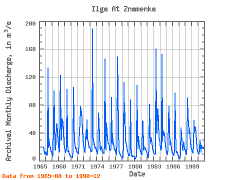
| Point ID: 6154 | Downloads | Plots | Site Data | Code: 3068 |
| Download | |
|---|---|
| Site Descriptor Information | Site Time Series Data |
| Link to all available data | |

|

|
| View: | Statistics | Time Series |
| Units: | mm |
| Statistic | Jan | Feb | Mar | Apr | May | Jun | Jul | Aug | Sep | Oct | Nov | Dec | Annual |
|---|---|---|---|---|---|---|---|---|---|---|---|---|---|
| Mean | 12.14 | 9.72 | 9.05 | 25.17 | 95.64 | 36.58 | 31.64 | 30.16 | 30.15 | 24.82 | 17.72 | 15.26 | 28.32 |
| Standard Deviation | 5.07 | 3.74 | 3.41 | 21.72 | 42.17 | 15.93 | 18.76 | 17.76 | 16.45 | 12.93 | 8.16 | 6.49 | 7.84 |
| Min | 4.20 | 2.73 | 3.22 | 6.78 | 30.00 | 12.40 | 8.93 | 6.23 | 7.57 | 5.84 | 6.02 | 5.78 | 15.32 |
| Max | 24.50 | 18.00 | 15.70 | 100.00 | 189.00 | 77.60 | 77.50 | 74.20 | 74.00 | 56.30 | 39.50 | 30.80 | 45.73 |
| Coefficient of Variation | 0.42 | 0.38 | 0.38 | 0.86 | 0.44 | 0.43 | 0.59 | 0.59 | 0.55 | 0.52 | 0.46 | 0.42 | 0.28 |
| Year | Jan | Feb | Mar | Apr | May | Jun | Jul | Aug | Sep | Oct | Nov | Dec | Annual | 1965 | 19.20 | 19.50 | 15.20 | 9.09 | 11.20 | 1966 | 13.30 | 9.35 | 7.21 | 10.40 | 133.00 | 18.70 | 31.60 | 22.10 | 20.40 | 17.30 | 13.20 | 13.40 | 25.83 | 1967 | 9.78 | 7.11 | 7.64 | 100.00 | 59.40 | 16.10 | 15.10 | 30.60 | 52.50 | 53.00 | 39.50 | 30.40 | 35.09 | 1968 | 21.70 | 14.80 | 12.80 | 77.80 | 122.00 | 29.10 | 30.40 | 60.10 | 55.30 | 41.50 | 25.60 | 18.80 | 42.49 | 1969 | 14.70 | 11.80 | 12.40 | 18.50 | 102.00 | 27.00 | 13.20 | 14.70 | 11.90 | 9.91 | 7.03 | 7.22 | 20.86 | 1970 | 5.43 | 5.21 | 4.65 | 15.50 | 105.00 | 53.80 | 27.70 | 23.40 | 17.80 | 19.00 | 14.70 | 11.60 | 25.32 | 1971 | 11.30 | 10.80 | 9.74 | 26.40 | 45.80 | 49.90 | 77.50 | 68.20 | 59.90 | 43.60 | 32.10 | 22.80 | 38.17 | 1972 | 16.50 | 13.60 | 12.10 | 25.70 | 42.50 | 31.40 | 58.40 | 30.30 | 29.80 | 24.80 | 19.30 | 19.90 | 27.02 | 1973 | 16.20 | 13.10 | 13.30 | 14.30 | 189.00 | 32.50 | 29.60 | 23.40 | 24.30 | 17.90 | 18.80 | 18.20 | 34.22 | 1974 | 14.10 | 11.30 | 9.59 | 19.20 | 68.70 | 53.30 | 19.10 | 15.50 | 20.50 | 18.80 | 15.70 | 11.80 | 23.13 | 1975 | 11.30 | 10.50 | 10.40 | 24.30 | 146.00 | 20.70 | 15.50 | 53.80 | 39.50 | 35.00 | 25.40 | 23.90 | 34.69 | 1976 | 18.10 | 14.80 | 15.10 | 17.60 | 90.70 | 25.40 | 39.10 | 23.00 | 25.10 | 18.80 | 15.70 | 16.10 | 26.62 | 1977 | 14.50 | 10.00 | 8.43 | 30.00 | 149.00 | 46.50 | 14.00 | 11.90 | 9.05 | 7.71 | 6.46 | 5.78 | 26.11 | 1978 | 5.28 | 4.08 | 3.84 | 23.90 | 112.00 | 53.70 | 69.60 | 27.80 | 26.20 | 21.90 | 13.50 | 11.70 | 31.12 | 1979 | 7.45 | 7.90 | 7.85 | 10.20 | 86.80 | 22.70 | 8.93 | 6.23 | 7.57 | 5.84 | 6.02 | 6.40 | 15.32 | 1980 | 4.38 | 2.73 | 3.22 | 6.78 | 108.00 | 36.00 | 17.30 | 35.10 | 23.70 | 19.80 | 15.20 | 13.80 | 23.83 | 1981 | 11.20 | 9.02 | 8.76 | 56.70 | 56.10 | 15.50 | 15.40 | 19.60 | 17.30 | 15.50 | 12.80 | 11.20 | 20.76 | 1982 | 7.10 | 4.94 | 5.07 | 20.00 | 80.80 | 39.70 | 25.60 | 33.10 | 28.90 | 25.80 | 18.50 | 15.00 | 25.38 | 1983 | 11.80 | 10.30 | 8.86 | 10.50 | 160.00 | 39.90 | 40.10 | 74.20 | 74.00 | 56.30 | 32.00 | 30.80 | 45.73 | 1984 | 24.50 | 18.00 | 15.70 | 17.90 | 152.00 | 28.30 | 44.10 | 36.30 | 39.80 | 29.60 | 21.50 | 16.70 | 37.03 | 1985 | 12.40 | 10.20 | 9.11 | 18.40 | 60.10 | 77.60 | 41.60 | 23.30 | 28.00 | 23.40 | 17.50 | 12.60 | 27.85 | 1986 | 9.25 | 7.98 | 7.43 | 15.70 | 97.10 | 46.00 | 15.00 | 12.10 | 13.10 | 10.50 | 8.05 | 6.13 | 20.70 | 1987 | 4.20 | 3.64 | 3.28 | 8.65 | 46.90 | 38.40 | 17.80 | 14.50 | 26.90 | 23.70 | 16.10 | 16.50 | 18.38 | 1988 | 13.70 | 10.80 | 9.10 | 22.60 | 90.00 | 59.80 | 57.80 | 39.40 | 45.60 | 35.60 | 19.00 | 16.50 | 34.99 | 1989 | 13.90 | 11.60 | 11.00 | 22.40 | 58.00 | 40.20 | 44.60 | 48.00 | 38.80 | 27.70 | 19.30 | 14.30 | 29.15 | 1990 | 11.40 | 9.46 | 9.63 | 15.80 | 30.00 | 12.40 | 21.90 | 18.20 | 28.40 | 27.20 | 18.60 | 14.10 | 18.09 |
|---|
 Return to R-Arctic Net Home Page