|
|
|||||||||||||||||
| Point ID: 5940 | Downloads | Plots | Site Data | Code: 1590 |
|
|
|||||||||||||||||
| Download | |
|---|---|
| Site Descriptor Information | Site Time Series Data |
| Link to all available data | |
|
|
| View: | Statistics | Time Series |
| Units: | mm |
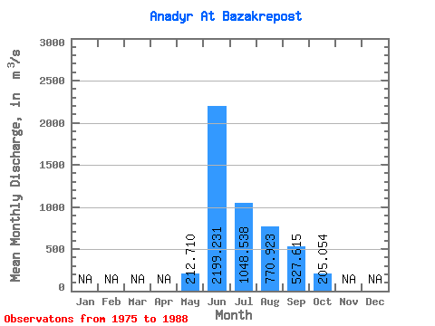
| Statistic | Jan | Feb | Mar | Apr | May | Jun | Jul | Aug | Sep | Oct | Nov | Dec | Annual |
|---|---|---|---|---|---|---|---|---|---|---|---|---|---|
| Mean | 212.71 | 2199.23 | 1048.54 | 770.92 | 527.62 | 205.05 | |||||||
| Standard Deviation | 189.82 | 621.17 | 510.38 | 305.96 | 281.78 | 136.92 | |||||||
| Min | 15.80 | 1130.00 | 367.00 | 250.00 | 173.00 | 56.80 | |||||||
| Max | 644.00 | 3130.00 | 2130.00 | 1300.00 | 1190.00 | 572.00 | |||||||
| Coefficient of Variation | 0.89 | 0.28 | 0.49 | 0.40 | 0.53 | 0.67 |
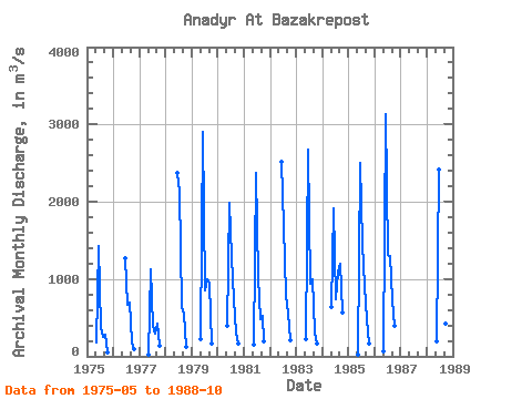
| Year | Jan | Feb | Mar | Apr | May | Jun | Jul | Aug | Sep | Oct | Nov | Dec | Annual | 1975 | 183.00 | 1420.00 | 367.00 | 250.00 | 274.00 | 56.80 | 1976 | 1270.00 | 665.00 | 689.00 | 173.00 | 95.90 | 1977 | 20.30 | 1130.00 | 397.00 | 289.00 | 426.00 | 135.00 | 1978 | 2370.00 | 2130.00 | 642.00 | 546.00 | 121.00 | 1979 | 229.00 | 2900.00 | 854.00 | 1000.00 | 933.00 | 163.00 | 1980 | 399.00 | 1980.00 | 1290.00 | 743.00 | 309.00 | 159.00 | 1981 | 157.00 | 2370.00 | 1030.00 | 475.00 | 520.00 | 193.00 | 1982 | 2520.00 | 1680.00 | 798.00 | 553.00 | 208.00 | 1983 | 228.00 | 2680.00 | 943.00 | 991.00 | 304.00 | 165.00 | 1984 | 644.00 | 1910.00 | 732.00 | 1090.00 | 1190.00 | 572.00 | 1985 | 15.80 | 2500.00 | 1460.00 | 909.00 | 486.00 | 172.00 | 1986 | 62.00 | 3130.00 | 1310.00 | 1300.00 | 722.00 | 398.00 | 1988 | 189.00 | 2410.00 | 773.00 | 846.00 | 423.00 | 227.00 |
|---|
 Return to R-Arctic Net Home Page