|
|
|||||||||||||||||
| Point ID: 5938 | Downloads | Plots | Site Data | Code: 1587 |
|
|
|||||||||||||||||
| Download | |
|---|---|
| Site Descriptor Information | Site Time Series Data |
| Link to all available data | |
|

|
| View: | Statistics | Time Series |
| Units: | mm |
| Statistic | Jan | Feb | Mar | Apr | May | Jun | Jul | Aug | Sep | Oct | Nov | Dec | Annual |
|---|---|---|---|---|---|---|---|---|---|---|---|---|---|
| Mean | 19.63 | 1160.36 | 511.67 | 311.27 | 215.42 | 85.94 | 23.10 | ||||||
| Standard Deviation | 19.36 | 431.32 | 323.82 | 96.14 | 84.03 | 47.26 | |||||||
| Min | 2.62 | 411.00 | 189.00 | 152.00 | 71.60 | 16.50 | 23.10 | ||||||
| Max | 41.90 | 1780.00 | 1170.00 | 450.00 | 365.00 | 152.00 | 23.10 | ||||||
| Coefficient of Variation | 0.99 | 0.37 | 0.63 | 0.31 | 0.39 | 0.55 |
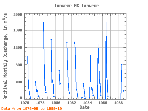
| Year | Jan | Feb | Mar | Apr | May | Jun | Jul | Aug | Sep | Oct | Nov | Dec | Annual | 1976 | 1000.00 | 267.00 | 213.00 | 127.00 | 16.50 | 1977 | 411.00 | 190.00 | 152.00 | 201.00 | 58.30 | 1978 | 1780.00 | 965.00 | 322.00 | 284.00 | 152.00 | 1979 | 1390.00 | 393.00 | 450.00 | 323.00 | 63.00 | 1980 | 664.00 | 336.00 | 371.00 | 1981 | 1320.00 | 756.00 | 423.00 | 215.00 | 139.00 | 1982 | 1320.00 | 1170.00 | 246.00 | 212.00 | 107.00 | 23.10 | 1983 | 39.30 | 363.00 | 259.00 | 165.00 | 19.10 | 1984 | 41.90 | 1020.00 | 189.00 | 274.00 | 217.00 | 83.50 | 1985 | 10.00 | 1270.00 | 744.00 | 372.00 | 365.00 | 92.00 | 1986 | 4.32 | 1780.00 | 513.00 | 423.30 | 71.60 | 1988 | 2.62 | 809.00 | 254.00 | 230.00 | 189.00 | 129.00 |
|---|
 Return to R-Arctic Net Home Page
