|
|
|||||||||||||||||
| Point ID: 5917 | Downloads | Plots | Site Data | Code: 1497 |
|
|
|||||||||||||||||
| Download | |
|---|---|
| Site Descriptor Information | Site Time Series Data |
| Link to all available data | |
|
|
| View: | Statistics | Time Series |
| Units: | mm |
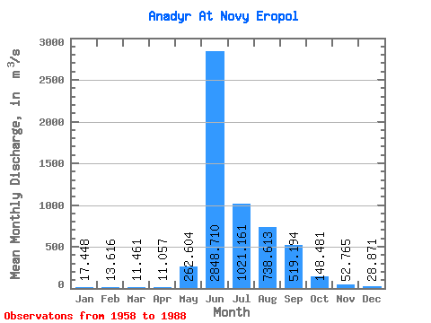
| Statistic | Jan | Feb | Mar | Apr | May | Jun | Jul | Aug | Sep | Oct | Nov | Dec | Annual |
|---|---|---|---|---|---|---|---|---|---|---|---|---|---|
| Mean | 17.45 | 13.62 | 11.46 | 11.06 | 262.60 | 2848.71 | 1021.16 | 738.61 | 519.19 | 148.48 | 52.77 | 28.87 | 472.83 |
| Standard Deviation | 4.54 | 4.49 | 4.00 | 4.52 | 500.54 | 765.14 | 468.23 | 241.80 | 307.28 | 85.75 | 22.68 | 11.03 | 107.53 |
| Min | 10.10 | 5.43 | 4.24 | 3.29 | 5.81 | 1440.00 | 385.00 | 314.00 | 180.00 | 64.10 | 25.30 | 12.00 | 306.30 |
| Max | 29.80 | 23.40 | 19.50 | 23.70 | 2090.00 | 4510.00 | 2200.00 | 1190.00 | 1290.00 | 449.00 | 131.00 | 58.70 | 756.69 |
| Coefficient of Variation | 0.26 | 0.33 | 0.35 | 0.41 | 1.91 | 0.27 | 0.46 | 0.33 | 0.59 | 0.58 | 0.43 | 0.38 | 0.23 |
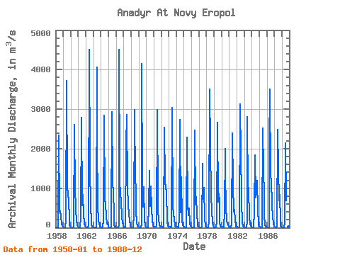
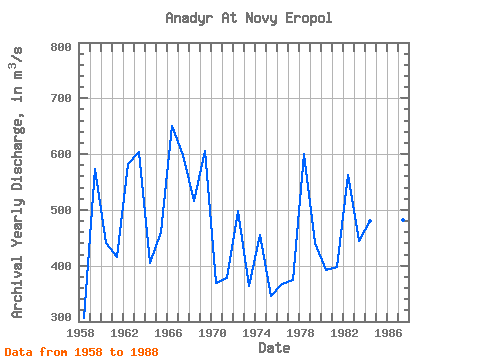
| Year | Jan | Feb | Mar | Apr | May | Jun | Jul | Aug | Sep | Oct | Nov | Dec | Annual | 1958 | 15.90 | 9.66 | 9.89 | 13.00 | 21.90 | 2340.00 | 407.00 | 429.00 | 295.00 | 71.90 | 38.60 | 23.70 | 306.30 | 1959 | 17.90 | 14.50 | 12.50 | 12.80 | 191.00 | 3710.00 | 984.00 | 930.00 | 604.00 | 313.00 | 56.60 | 27.10 | 572.78 | 1960 | 17.00 | 12.30 | 11.20 | 10.00 | 20.00 | 2600.00 | 835.00 | 1050.00 | 456.00 | 180.00 | 60.00 | 26.50 | 439.83 | 1961 | 13.90 | 9.10 | 10.90 | 10.20 | 277.00 | 2780.00 | 557.00 | 838.00 | 341.00 | 100.00 | 37.50 | 21.10 | 416.31 | 1962 | 13.90 | 12.40 | 12.60 | 10.40 | 51.30 | 4510.00 | 1570.00 | 513.00 | 187.00 | 68.10 | 30.80 | 16.90 | 583.03 | 1963 | 13.50 | 12.90 | 9.38 | 9.78 | 15.80 | 4060.00 | 2200.00 | 573.00 | 182.00 | 104.00 | 33.40 | 21.80 | 602.96 | 1964 | 14.20 | 10.90 | 8.86 | 8.50 | 184.00 | 2840.00 | 705.00 | 596.00 | 287.00 | 90.50 | 75.90 | 36.80 | 404.81 | 1965 | 21.80 | 9.02 | 7.64 | 5.76 | 23.70 | 2930.00 | 1170.00 | 862.00 | 391.00 | 64.10 | 31.10 | 19.10 | 461.27 | 1966 | 11.90 | 11.30 | 9.98 | 9.24 | 44.40 | 4510.00 | 1230.00 | 823.00 | 703.00 | 262.00 | 131.00 | 54.00 | 649.99 | 1967 | 14.50 | 10.50 | 8.87 | 10.10 | 2090.00 | 2850.00 | 1010.00 | 578.00 | 353.00 | 166.00 | 65.60 | 27.00 | 598.63 | 1968 | 18.80 | 15.20 | 13.40 | 13.00 | 329.00 | 2980.00 | 1130.00 | 1070.00 | 432.00 | 120.00 | 44.40 | 27.30 | 516.09 | 1969 | 20.90 | 15.10 | 12.60 | 16.00 | 91.70 | 4140.00 | 1150.00 | 529.00 | 1030.00 | 181.00 | 50.80 | 28.80 | 605.49 | 1970 | 17.40 | 13.30 | 11.90 | 12.00 | 565.00 | 1440.00 | 553.00 | 1050.00 | 497.00 | 163.00 | 58.10 | 39.40 | 368.34 | 1971 | 22.60 | 18.60 | 18.70 | 23.70 | 50.70 | 2980.00 | 679.00 | 430.00 | 199.00 | 70.20 | 25.30 | 19.60 | 378.12 | 1972 | 19.20 | 20.00 | 15.50 | 17.00 | 28.60 | 2540.00 | 1150.00 | 1020.00 | 922.00 | 148.00 | 52.60 | 36.20 | 497.43 | 1973 | 29.80 | 23.40 | 19.50 | 16.70 | 23.30 | 3030.00 | 515.00 | 362.00 | 203.00 | 69.70 | 41.40 | 24.80 | 363.22 | 1974 | 18.00 | 18.00 | 17.70 | 17.20 | 219.00 | 2730.00 | 385.00 | 467.00 | 1290.00 | 181.00 | 58.70 | 58.70 | 455.02 | 1975 | 13.50 | 12.40 | 11.00 | 13.40 | 295.00 | 2280.00 | 566.00 | 314.00 | 489.00 | 101.00 | 38.80 | 22.30 | 346.37 | 1976 | 10.10 | 7.08 | 7.15 | 3.62 | 5.81 | 2470.00 | 605.00 | 772.00 | 324.00 | 121.00 | 51.10 | 23.10 | 366.66 | 1977 | 18.70 | 16.40 | 12.80 | 10.10 | 33.20 | 1620.00 | 727.00 | 741.00 | 1010.00 | 241.00 | 44.50 | 25.80 | 375.04 | 1978 | 16.60 | 15.40 | 13.80 | 14.20 | 164.00 | 3510.00 | 2030.00 | 809.00 | 431.00 | 122.00 | 41.70 | 27.00 | 599.56 | 1979 | 17.90 | 16.10 | 13.20 | 11.80 | 175.00 | 2670.00 | 654.00 | 866.00 | 667.00 | 121.00 | 41.80 | 27.60 | 440.12 | 1980 | 23.40 | 21.60 | 17.70 | 13.30 | 395.00 | 1990.00 | 1360.00 | 521.00 | 180.00 | 90.60 | 61.30 | 30.70 | 392.05 | 1981 | 19.20 | 14.80 | 13.10 | 11.80 | 89.20 | 2400.00 | 1080.00 | 403.00 | 465.00 | 181.00 | 53.50 | 31.90 | 396.88 | 1982 | 26.90 | 19.10 | 15.20 | 14.00 | 22.10 | 3130.00 | 1820.00 | 851.00 | 656.00 | 127.00 | 47.00 | 25.40 | 562.81 | 1983 | 17.60 | 13.80 | 11.60 | 9.48 | 147.00 | 2800.00 | 891.00 | 1020.00 | 250.00 | 106.00 | 51.70 | 21.40 | 444.96 | 1984 | 10.30 | 7.13 | 4.47 | 5.75 | 395.00 | 1830.00 | 760.00 | 976.00 | 1190.00 | 449.00 | 93.80 | 47.30 | 480.73 | 1985 | 21.20 | 18.80 | 8.51 | 4.81 | 16.20 | 2510.00 | 1460.00 | 822.00 | 337.00 | 65.30 | 35.60 | 27.30 | 443.89 | 1986 | 14.60 | 8.79 | 5.08 | 6.48 | 2035.00 | 3500.00 | 1300.00 | 1190.00 | 591.00 | 275.00 | 105.00 | 49.30 | 756.69 | 1987 | 18.20 | 9.08 | 6.33 | 5.37 | 18.80 | 2490.00 | 1480.00 | 693.00 | 835.00 | 162.00 | 44.60 | 15.10 | 481.46 | 1988 | 11.50 | 5.43 | 4.24 | 3.29 | 123.00 | 2140.00 | 693.00 | 799.00 | 298.00 | 88.50 | 33.50 | 12.00 | 350.95 |
|---|
 Return to R-Arctic Net Home Page