|
|
|||||||||||||||||
| Point ID: 5911 | Downloads | Plots | Site Data | Code: 1421 |
|
|
|||||||||||||||||
| Download | |
|---|---|
| Site Descriptor Information | Site Time Series Data |
| Link to all available data | |
|
|
| View: | Statistics | Time Series |
| Units: | mm |
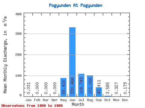
| Statistic | Jan | Feb | Mar | Apr | May | Jun | Jul | Aug | Sep | Oct | Nov | Dec | Annual |
|---|---|---|---|---|---|---|---|---|---|---|---|---|---|
| Mean | 0.03 | 0.00 | 0.00 | 0.00 | 88.43 | 330.47 | 108.74 | 101.07 | 43.41 | 3.58 | 0.33 | 0.18 | 74.70 |
| Standard Deviation | 0.06 | 0.00 | 0.00 | 0.00 | 101.98 | 168.96 | 70.58 | 81.98 | 29.32 | 2.43 | 0.31 | 0.42 | 14.45 |
| Min | 0.00 | 0.00 | 0.00 | 0.00 | 0.68 | 71.50 | 31.50 | 16.30 | 7.72 | 0.99 | 0.01 | 0.00 | 59.05 |
| Max | 0.12 | 0.00 | 0.00 | 0.00 | 472.00 | 809.00 | 316.00 | 381.00 | 118.00 | 13.70 | 1.23 | 1.12 | 87.53 |
| Coefficient of Variation | 1.88 | 1.15 | 0.51 | 0.65 | 0.81 | 0.68 | 0.68 | 0.95 | 2.33 | 0.19 |
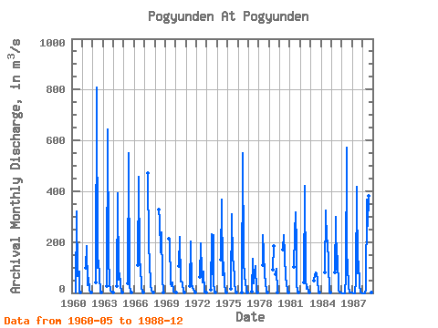
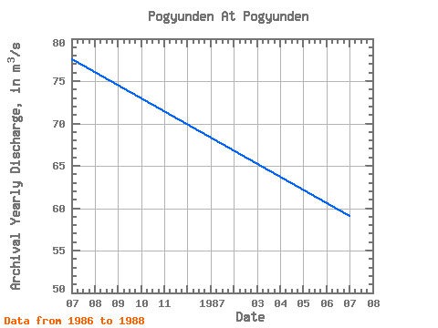
| Year | Jan | Feb | Mar | Apr | May | Jun | Jul | Aug | Sep | Oct | Nov | Dec | Annual | 1960 | 0.79 | 319.00 | 65.30 | 66.00 | 83.20 | 4.57 | 0.10 | 1961 | 97.90 | 184.00 | 31.50 | 58.10 | 11.20 | 1.71 | 0.10 | 1962 | 39.80 | 809.00 | 98.00 | 128.00 | 65.30 | 1.77 | 0.35 | 1963 | 25.70 | 643.00 | 148.00 | 36.80 | 7.72 | 4.18 | 0.46 | 0.00 | 1964 | 25.30 | 394.00 | 50.50 | 77.80 | 33.50 | 3.29 | 0.33 | 1965 | 36.40 | 551.00 | 34.70 | 23.00 | 10.60 | 0.99 | 1966 | 108.00 | 456.00 | 130.00 | 98.50 | 26.30 | 2.47 | 0.17 | 1967 | 472.00 | 176.00 | 126.00 | 26.20 | 13.10 | 2.73 | 0.35 | 1968 | 327.00 | 288.00 | 161.00 | 240.00 | 62.00 | 2.98 | 0.37 | 1969 | 213.00 | 203.00 | 36.60 | 26.30 | 42.00 | 6.03 | 1.23 | 1.12 | 1970 | 0.12 | 104.00 | 220.00 | 44.70 | 46.20 | 36.60 | 2.41 | 0.04 | 1971 | 28.20 | 203.00 | 33.00 | 21.30 | 15.40 | 1.60 | 0.05 | 1972 | 63.00 | 195.00 | 80.70 | 41.40 | 83.90 | 2.56 | 0.53 | 0.01 | 1973 | 13.80 | 230.00 | 72.90 | 229.00 | 46.20 | 2.66 | 0.18 | 1974 | 132.00 | 366.00 | 70.00 | 120.00 | 34.90 | 5.02 | 0.94 | 1975 | 15.60 | 310.00 | 128.00 | 125.00 | 44.00 | 2.24 | 0.41 | 1976 | 0.68 | 551.00 | 135.00 | 54.70 | 49.00 | 4.38 | 0.02 | 1977 | 3.59 | 136.00 | 39.10 | 77.60 | 104.00 | 6.39 | 0.08 | 1978 | 108.00 | 229.00 | 160.00 | 69.40 | 43.40 | 2.19 | 0.01 | 1979 | 91.00 | 184.00 | 73.00 | 93.20 | 1.87 | 1980 | 171.00 | 229.00 | 154.00 | 51.90 | 45.20 | 3.62 | 0.36 | 1981 | 101.00 | 233.00 | 316.00 | 182.00 | 31.60 | 13.70 | 0.29 | 1982 | 42.80 | 422.00 | 55.50 | 16.30 | 24.00 | 1.92 | 0.14 | 1983 | 48.90 | 71.50 | 79.90 | 78.40 | 47.90 | 6.05 | 1.08 | 1984 | 81.00 | 324.00 | 204.00 | 205.00 | 118.00 | 4.87 | 0.17 | 1985 | 79.10 | 300.00 | 93.10 | 145.00 | 10.70 | 2.45 | 0.32 | 0.01 | 1986 | 0.00 | 0.00 | 0.00 | 0.00 | 67.00 | 573.00 | 157.00 | 108.00 | 23.30 | 1.84 | 0.09 | 0.12 | 77.53 | 1987 | 0.01 | 0.00 | 0.00 | 0.00 | 53.70 | 418.00 | 76.30 | 125.00 | 32.10 | 3.28 | 0.26 | 0.00 | 59.05 | 1988 | 0.00 | 0.00 | 0.00 | 0.00 | 14.20 | 366.00 | 264.00 | 381.00 | 20.60 | 4.20 | 0.39 | 0.00 | 87.53 |
|---|
 Return to R-Arctic Net Home Page