|
|
|||||||||||||||||
| Point ID: 584 | Downloads | Plots | Site Data | Code: 07AA003 |
|
|
|||||||||||||||||
| Download | |
|---|---|
| Site Descriptor Information | Site Time Series Data |
| Link to all available data | |
|

|
| View: | Statistics | Time Series |
| Units: | mm |
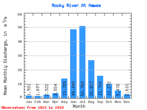
| Statistic | Jan | Feb | Mar | Apr | May | Jun | Jul | Aug | Sep | Oct | Nov | Dec | Annual |
|---|---|---|---|---|---|---|---|---|---|---|---|---|---|
| Mean | 1.93 | 1.70 | 2.52 | 3.55 | 13.78 | 48.44 | 50.76 | 26.82 | 15.70 | 10.27 | 5.48 | 2.61 | 14.72 |
| Standard Deviation | 1.09 | 1.43 | 1.08 | 1.47 | 3.04 | 10.75 | 8.70 | 11.52 | 3.39 | 2.73 | 0.85 | 1.02 | 1.25 |
| Min | 0.34 | 0.73 | 1.35 | 1.65 | 9.60 | 37.10 | 39.10 | 15.40 | 12.90 | 7.08 | 4.51 | 1.67 | 13.12 |
| Max | 3.14 | 4.13 | 4.22 | 5.60 | 17.70 | 64.10 | 60.40 | 46.30 | 22.20 | 14.70 | 6.49 | 4.14 | 15.82 |
| Coefficient of Variation | 0.56 | 0.84 | 0.43 | 0.41 | 0.22 | 0.22 | 0.17 | 0.43 | 0.22 | 0.27 | 0.15 | 0.39 | 0.09 |
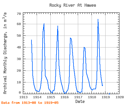
| Year | Jan | Feb | Mar | Apr | May | Jun | Jul | Aug | Sep | Oct | Nov | Dec | Annual | 1913 | 46.30 | 16.10 | 8.04 | 4.68 | 2.71 | 1914 | 2.72 | 1.86 | 2.12 | 5.60 | 14.30 | 52.80 | 60.40 | 15.40 | 13.30 | 11.10 | 4.51 | 2.86 | 15.58 | 1915 | 1.58 | 0.73 | 2.83 | 2.87 | 11.70 | 37.10 | 58.30 | 25.10 | 14.90 | 9.41 | 5.95 | 1.67 | 14.35 | 1916 | 0.34 | 0.95 | 2.09 | 3.48 | 9.60 | 48.10 | 47.00 | 34.00 | 22.20 | 14.70 | 5.76 | 1.67 | 15.82 | 1917 | 1.87 | 0.82 | 1.35 | 1.65 | 17.70 | 40.10 | 39.10 | 18.10 | 14.80 | 11.30 | 6.49 | 4.14 | 13.12 | 1918 | 3.14 | 4.13 | 4.22 | 4.17 | 12.80 | 64.10 | 49.00 | 22.00 | 12.90 | 7.08 | 1919 | 16.60 |
|---|
 Return to R-Arctic Net Home Page