|
|
|||||||||||||||||
| Point ID: 5838 | Downloads | Plots | Site Data | Code: 09FD002 |
|
|
|||||||||||||||||
| Download | |
|---|---|
| Site Descriptor Information | Site Time Series Data |
| Link to all available data | |
|
|
| View: | Statistics | Time Series |
| Units: | mm |
| Statistic | Jan | Feb | Mar | Apr | May | Jun | Jul | Aug | Sep | Oct | Nov | Dec | Annual |
|---|---|---|---|---|---|---|---|---|---|---|---|---|---|
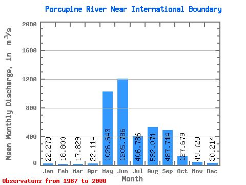
| Mean | 22.28 | 18.80 | 17.83 | 22.11 | 1026.64 | 1205.79 | 406.79 | 532.07 | 487.71 | 127.68 | 49.73 | 30.21 | 328.97 |
| Standard Deviation | 3.63 | 3.75 | 3.38 | 9.33 | 547.03 | 509.01 | 221.74 | 205.54 | 193.14 | 45.16 | 15.12 | 5.03 | 71.69 |
| Min | 15.60 | 11.30 | 10.80 | 15.40 | 170.00 | 578.00 | 164.00 | 285.00 | 218.00 | 72.80 | 31.80 | 24.60 | 170.23 |
| Max | 28.10 | 24.20 | 24.10 | 48.40 | 1820.00 | 2450.00 | 834.00 | 1070.00 | 973.00 | 233.00 | 89.50 | 41.90 | 480.08 |
| Coefficient of Variation | 0.16 | 0.20 | 0.19 | 0.42 | 0.53 | 0.42 | 0.55 | 0.39 | 0.40 | 0.35 | 0.30 | 0.17 | 0.22 |
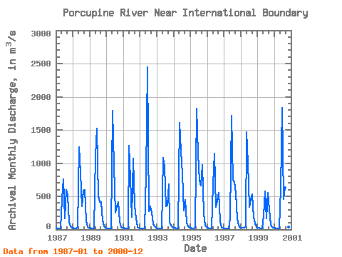
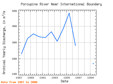
| Year | Jan | Feb | Mar | Apr | May | Jun | Jul | Aug | Sep | Oct | Nov | Dec | Annual | 1987 | 21.80 | 19.60 | 17.10 | 15.40 | 456.00 | 758.00 | 164.00 | 602.00 | 512.00 | 112.00 | 49.00 | 31.00 | 229.82 | 1988 | 24.00 | 19.00 | 18.50 | 21.90 | 1240.00 | 858.00 | 348.00 | 583.00 | 598.00 | 121.00 | 39.50 | 27.00 | 324.82 | 1989 | 22.10 | 19.50 | 17.60 | 16.80 | 1110.00 | 1520.00 | 495.00 | 417.00 | 414.00 | 133.00 | 51.60 | 26.80 | 353.62 | 1990 | 18.90 | 15.30 | 13.60 | 16.50 | 1790.00 | 964.00 | 253.00 | 349.00 | 419.00 | 109.00 | 41.50 | 28.20 | 334.83 | 1991 | 22.70 | 20.10 | 17.90 | 16.70 | 1260.00 | 771.00 | 184.00 | 1070.00 | 362.00 | 170.00 | 40.50 | 25.60 | 330.04 | 1992 | 18.00 | 14.60 | 19.60 | 21.30 | 842.00 | 2450.00 | 278.00 | 346.00 | 255.00 | 79.20 | 43.90 | 27.90 | 366.29 | 1993 | 18.60 | 14.90 | 15.20 | 19.50 | 1080.00 | 942.00 | 345.00 | 361.00 | 687.00 | 116.00 | 57.10 | 37.90 | 307.85 | 1994 | 27.70 | 21.90 | 19.10 | 20.20 | 1610.00 | 1190.00 | 834.00 | 285.00 | 444.00 | 104.00 | 52.60 | 32.30 | 386.73 | 1995 | 22.00 | 16.70 | 15.10 | 37.60 | 1820.00 | 1150.00 | 735.00 | 661.00 | 973.00 | 233.00 | 63.80 | 33.80 | 480.08 | 1996 | 25.40 | 21.40 | 19.10 | 19.30 | 679.00 | 1150.00 | 340.00 | 420.00 | 554.00 | 120.00 | 31.80 | 25.00 | 283.75 | 1997 | 15.60 | 11.30 | 10.80 | 15.90 | 170.00 | 1710.00 | 749.00 | 719.00 | 548.00 | 162.00 | 61.90 | 29.10 | 350.22 | 1998 | 24.90 | 24.20 | 24.10 | 48.40 | 1470.00 | 1010.00 | 337.00 | 454.00 | 535.00 | 181.00 | 89.50 | 41.90 | 353.33 | 1999 | 28.10 | 23.60 | 21.40 | 19.40 | 213.00 | 578.00 | 171.00 | 549.00 | 309.00 | 72.80 | 32.90 | 24.60 | 170.23 | 2000 | 22.10 | 21.10 | 20.50 | 20.70 | 633.00 | 1830.00 | 462.00 | 633.00 | 218.00 | 74.50 | 40.60 | 31.90 | 333.95 |
|---|
 Return to R-Arctic Net Home Page