|
|
|||||||||||||||||
| Point ID: 5807 | Downloads | Plots | Site Data | Code: 09BC002 |
|
|
|||||||||||||||||
| Download | |
|---|---|
| Site Descriptor Information | Site Time Series Data |
| Link to all available data | |
|

|
| View: | Statistics | Time Series |
| Units: | mm |
| Statistic | Jan | Feb | Mar | Apr | May | Jun | Jul | Aug | Sep | Oct | Nov | Dec | Annual |
|---|---|---|---|---|---|---|---|---|---|---|---|---|---|
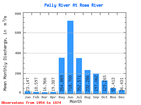
| Mean | 23.15 | 18.60 | 16.97 | 19.39 | 354.89 | 718.70 | 352.57 | 232.29 | 197.06 | 129.26 | 55.41 | 36.43 | 186.54 |
| Standard Deviation | 8.27 | 5.76 | 4.68 | 3.73 | 104.06 | 232.67 | 90.13 | 77.20 | 70.07 | 38.05 | 15.40 | 12.25 | 30.05 |
| Min | 8.86 | 6.95 | 6.45 | 10.90 | 110.00 | 358.00 | 177.00 | 131.00 | 59.30 | 61.00 | 37.00 | 16.60 | 146.25 |
| Max | 39.10 | 30.60 | 24.10 | 24.90 | 500.00 | 1320.00 | 543.00 | 417.00 | 342.00 | 185.00 | 84.30 | 60.40 | 247.40 |
| Coefficient of Variation | 0.36 | 0.31 | 0.28 | 0.19 | 0.29 | 0.32 | 0.26 | 0.33 | 0.36 | 0.29 | 0.28 | 0.34 | 0.16 |
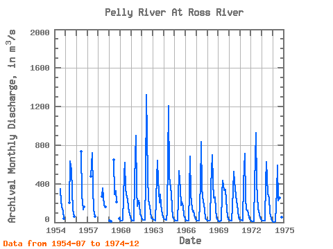
| Year | Jan | Feb | Mar | Apr | May | Jun | Jul | Aug | Sep | Oct | Nov | Dec | Annual | 1954 | 349.00 | 208.00 | 136.00 | 115.00 | 39.10 | 1955 | 204.00 | 637.00 | 543.00 | 325.00 | 133.00 | 61.00 | 1956 | 734.00 | 283.00 | 135.00 | 162.00 | 1957 | 475.00 | 722.00 | 353.00 | 132.00 | 59.30 | 1958 | 267.00 | 358.00 | 177.00 | 169.00 | 162.00 | 1959 | 21.20 | 16.40 | 13.70 | 646.00 | 289.00 | 324.00 | 215.00 | 38.20 | 1960 | 27.00 | 20.20 | 17.20 | 24.90 | 500.00 | 622.00 | 342.00 | 256.00 | 250.00 | 153.00 | 80.00 | 51.00 | 195.28 | 1961 | 34.50 | 21.50 | 21.50 | 19.30 | 445.00 | 901.00 | 328.00 | 165.00 | 229.00 | 184.00 | 82.10 | 51.00 | 206.82 | 1962 | 34.00 | 22.70 | 22.70 | 22.70 | 429.00 | 1320.00 | 487.00 | 234.00 | 198.00 | 111.00 | 48.10 | 39.60 | 247.40 | 1963 | 31.10 | 27.20 | 23.80 | 21.00 | 463.00 | 643.00 | 433.00 | 203.00 | 289.00 | 185.00 | 84.30 | 55.50 | 204.91 | 1964 | 39.10 | 30.60 | 24.10 | 23.80 | 110.00 | 1210.00 | 473.00 | 417.00 | 294.00 | 153.00 | 51.90 | 34.10 | 238.38 | 1965 | 21.00 | 14.80 | 14.70 | 19.60 | 233.00 | 536.00 | 351.00 | 176.00 | 212.00 | 170.00 | 68.40 | 60.40 | 156.41 | 1966 | 17.00 | 16.40 | 16.40 | 18.30 | 324.00 | 683.00 | 291.00 | 139.00 | 112.00 | 115.00 | 46.90 | 30.50 | 150.79 | 1967 | 22.40 | 18.30 | 16.20 | 19.00 | 386.00 | 836.00 | 350.00 | 211.00 | 189.00 | 124.00 | 41.80 | 24.40 | 186.51 | 1968 | 21.10 | 19.40 | 19.10 | 21.70 | 374.00 | 701.00 | 419.00 | 258.00 | 262.00 | 139.00 | 48.80 | 25.70 | 192.40 | 1969 | 12.60 | 12.40 | 11.90 | 17.40 | 293.00 | 437.00 | 334.00 | 330.00 | 342.00 | 135.00 | 60.70 | 35.70 | 168.47 | 1970 | 22.30 | 18.90 | 18.50 | 21.30 | 324.00 | 524.00 | 422.00 | 284.00 | 221.00 | 184.00 | 55.90 | 30.00 | 177.16 | 1971 | 24.20 | 22.90 | 17.10 | 20.40 | 413.00 | 715.00 | 246.00 | 131.00 | 127.00 | 91.40 | 46.20 | 27.10 | 156.78 | 1972 | 16.10 | 13.90 | 13.30 | 13.00 | 407.00 | 930.00 | 408.00 | 259.00 | 150.00 | 81.30 | 43.50 | 30.20 | 197.11 | 1973 | 17.90 | 15.00 | 14.80 | 17.50 | 417.00 | 625.00 | 301.00 | 270.00 | 255.00 | 94.80 | 37.00 | 16.60 | 173.47 | 1974 | 8.86 | 6.95 | 6.45 | 10.90 | 324.00 | 594.00 | 225.00 | 252.00 | 141.00 | 101.00 | 51.90 | 32.90 | 146.25 |
|---|
 Return to R-Arctic Net Home Page