|
|
|||||||||||||||||
| Point ID: 5211 | Downloads | Plots | Site Data | Code: 05GC003 |
|
|
|||||||||||||||||
| Download | |
|---|---|
| Site Descriptor Information | Site Time Series Data |
| Link to all available data | |
|
|
| View: | Statistics | Time Series |
| Units: | mm |
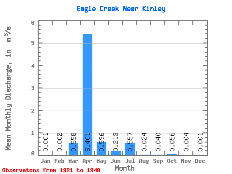
| Statistic | Jan | Feb | Mar | Apr | May | Jun | Jul | Aug | Sep | Oct | Nov | Dec | Annual |
|---|---|---|---|---|---|---|---|---|---|---|---|---|---|
| Mean | 0.00 | 0.00 | 0.56 | 5.40 | 0.60 | 0.21 | 0.56 | 0.02 | 0.04 | 0.06 | 0.00 | 0.00 | 0.54 |
| Standard Deviation | 0.00 | 0.00 | 0.65 | 4.72 | 0.43 | 0.19 | 1.28 | 0.04 | 0.08 | 0.08 | 0.00 | 0.00 | 0.53 |
| Min | 0.00 | 0.00 | 0.00 | 0.78 | 0.22 | 0.04 | 0.00 | 0.00 | 0.00 | 0.00 | 0.00 | 0.00 | 0.09 |
| Max | 0.00 | 0.00 | 1.45 | 11.50 | 1.16 | 0.46 | 3.16 | 0.10 | 0.20 | 0.23 | 0.01 | 0.00 | 1.20 |
| Coefficient of Variation | 1.37 | 0.99 | 1.16 | 0.87 | 0.72 | 0.89 | 2.29 | 1.69 | 1.97 | 1.49 | 1.15 | 1.26 | 0.97 |
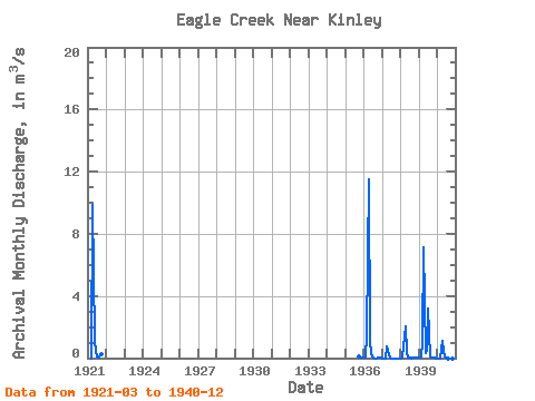
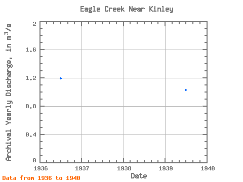
| Year | Jan | Feb | Mar | Apr | May | Jun | Jul | Aug | Sep | Oct | Nov | Dec | Annual | 1921 | 0.00 | 9.84 | 1.16 | 0.42 | 0.12 | 0.05 | 0.20 | 0.23 | 1935 | 0.08 | 0.01 | 0.00 | 1936 | 0.00 | 0.00 | 1.45 | 11.50 | 1.13 | 0.22 | 0.02 | 0.00 | 0.00 | 0.01 | 0.00 | 0.00 | 1.20 | 1937 | 0.00 | 0.00 | 0.00 | 0.78 | 0.22 | 0.04 | 0.00 | 0.00 | 0.00 | 0.00 | 0.00 | 0.00 | 0.09 | 1938 | 0.00 | 0.00 | 0.78 | 2.05 | 0.30 | 0.05 | 0.01 | 0.00 | 0.01 | 0.05 | 0.01 | 0.00 | 0.27 | 1939 | 0.00 | 0.00 | 1.12 | 7.16 | 0.32 | 0.46 | 3.16 | 0.10 | 0.03 | 0.02 | 0.00 | 0.00 | 1.03 | 1940 | 0.00 | 0.00 | 0.00 | 1.08 | 0.45 | 0.09 | 0.02 | 0.00 | 0.00 | 0.00 | 0.00 | 0.00 | 0.14 |
|---|
 Return to R-Arctic Net Home Page