|
|
|||||||||||||||||
| Point ID: 5187 | Downloads | Plots | Site Data | Code: 04NA002 |
|
|
|||||||||||||||||
| Download | |
|---|---|
| Site Descriptor Information | Site Time Series Data |
| Link to all available data | |
|
|
| View: | Statistics | Time Series |
| Units: | mm |
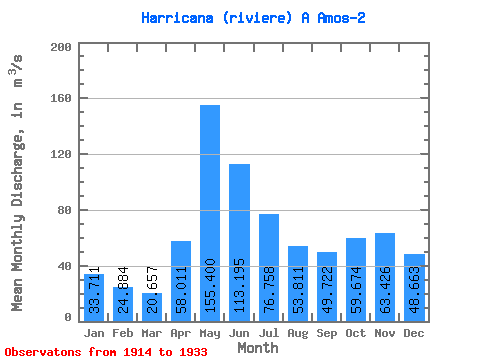
| Statistic | Jan | Feb | Mar | Apr | May | Jun | Jul | Aug | Sep | Oct | Nov | Dec | Annual |
|---|---|---|---|---|---|---|---|---|---|---|---|---|---|
| Mean | 33.71 | 24.88 | 20.66 | 58.01 | 155.40 | 113.19 | 76.76 | 53.81 | 49.72 | 59.67 | 63.43 | 48.66 | 63.37 |
| Standard Deviation | 11.09 | 9.92 | 8.14 | 31.90 | 43.23 | 36.92 | 32.74 | 24.60 | 21.65 | 36.24 | 32.41 | 17.09 | 16.36 |
| Min | 15.40 | 10.70 | 8.98 | 15.00 | 85.60 | 63.70 | 34.60 | 22.80 | 19.50 | 9.40 | 13.00 | 16.80 | 39.63 |
| Max | 51.60 | 48.40 | 46.20 | 125.00 | 258.00 | 191.00 | 135.00 | 94.20 | 107.00 | 155.00 | 151.00 | 77.70 | 108.80 |
| Coefficient of Variation | 0.33 | 0.40 | 0.39 | 0.55 | 0.28 | 0.33 | 0.43 | 0.46 | 0.43 | 0.61 | 0.51 | 0.35 | 0.26 |
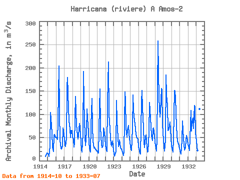
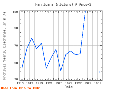
| Year | Jan | Feb | Mar | Apr | May | Jun | Jul | Aug | Sep | Oct | Nov | Dec | Annual | 1914 | 9.40 | 13.00 | 16.80 | 1915 | 15.90 | 13.60 | 8.98 | 32.00 | 104.00 | 89.60 | 59.50 | 29.20 | 19.50 | 55.50 | 56.30 | 49.90 | 44.50 | 1916 | 51.60 | 48.40 | 46.20 | 85.10 | 204.00 | 105.00 | 43.40 | 26.70 | 25.30 | 31.70 | 70.60 | 65.20 | 66.93 | 1917 | 46.30 | 33.60 | 30.30 | 48.20 | 158.00 | 179.00 | 112.00 | 86.50 | 68.50 | 49.70 | 65.50 | 64.80 | 78.53 | 1918 | 51.60 | 46.10 | 29.70 | 39.00 | 138.00 | 105.00 | 78.20 | 54.20 | 46.70 | 54.60 | 80.20 | 71.00 | 66.19 | 1919 | 40.60 | 23.90 | 19.20 | 57.60 | 192.00 | 129.00 | 51.10 | 32.30 | 62.30 | 111.00 | 91.20 | 63.20 | 72.78 | 1920 | 37.00 | 21.40 | 19.20 | 76.30 | 134.00 | 73.10 | 42.70 | 27.30 | 28.20 | 23.90 | 23.70 | 20.90 | 43.98 | 1921 | 20.90 | 16.40 | 16.80 | 114.00 | 154.00 | 71.10 | 34.60 | 28.40 | 32.20 | 70.40 | 66.90 | 49.40 | 56.26 | 1922 | 33.20 | 22.50 | 19.90 | 125.00 | 212.00 | 98.40 | 85.70 | 50.20 | 35.90 | 31.20 | 42.80 | 31.40 | 65.68 | 1923 | 15.40 | 10.70 | 13.00 | 19.40 | 130.00 | 84.10 | 50.60 | 30.90 | 44.10 | 36.90 | 27.50 | 25.20 | 40.65 | 1924 | 22.10 | 15.50 | 11.70 | 21.00 | 148.00 | 129.00 | 70.60 | 51.20 | 66.30 | 75.30 | 58.00 | 47.60 | 59.69 | 1925 | 30.60 | 25.20 | 22.00 | 67.90 | 141.00 | 108.00 | 85.00 | 80.30 | 56.00 | 52.00 | 49.10 | 46.30 | 63.62 | 1926 | 30.70 | 20.50 | 15.80 | 15.00 | 125.00 | 151.00 | 113.00 | 69.90 | 39.30 | 28.10 | 50.70 | 55.00 | 59.50 | 1927 | 30.10 | 19.30 | 19.50 | 60.80 | 125.00 | 108.00 | 74.20 | 53.90 | 43.30 | 68.40 | 70.20 | 54.70 | 60.62 | 1928 | 39.70 | 28.40 | 21.30 | 47.30 | 258.00 | 191.00 | 135.00 | 94.20 | 107.00 | 155.00 | 151.00 | 77.70 | 108.80 | 1929 | 44.70 | 29.10 | 20.90 | 44.10 | 184.00 | 141.00 | 119.00 | 65.10 | 68.50 | 76.10 | 83.70 | 50.30 | 77.21 | 1930 | 31.00 | 22.80 | 19.10 | 46.30 | 151.00 | 150.00 | 134.00 | 73.70 | 53.90 | 42.00 | 36.10 | 31.30 | 65.93 | 1931 | 22.00 | 17.10 | 14.70 | 43.80 | 85.60 | 63.70 | 35.00 | 22.80 | 28.60 | 43.60 | 54.60 | 44.10 | 39.63 | 1932 | 35.10 | 28.30 | 22.30 | 47.40 | 108.00 | 63.70 | 82.90 | 91.80 | 69.40 | 119.00 | 114.00 | 59.80 | 70.14 | 1933 | 42.00 | 30.00 | 21.90 | 112.00 | 201.00 | 111.00 | 51.90 |
|---|
 Return to R-Arctic Net Home Page