|
|
|||||||||||||||||
| Point ID: 5185 | Downloads | Plots | Site Data | Code: 03ME002 |
|
|
|||||||||||||||||
| Download | |
|---|---|
| Site Descriptor Information | Site Time Series Data |
| Link to all available data | |
|
|
| View: | Statistics | Time Series |
| Units: | mm |
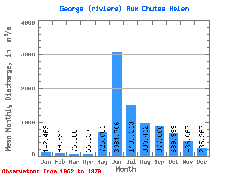
| Statistic | Jan | Feb | Mar | Apr | May | Jun | Jul | Aug | Sep | Oct | Nov | Dec | Annual |
|---|---|---|---|---|---|---|---|---|---|---|---|---|---|
| Mean | 142.46 | 99.53 | 76.39 | 66.64 | 725.08 | 3084.71 | 1499.31 | 990.41 | 877.60 | 689.33 | 436.07 | 235.27 | 739.49 |
| Standard Deviation | 34.85 | 21.01 | 16.57 | 18.35 | 924.89 | 757.53 | 450.31 | 260.16 | 258.86 | 136.16 | 141.39 | 70.39 | 85.06 |
| Min | 97.40 | 71.60 | 51.50 | 41.00 | 40.50 | 1680.00 | 888.00 | 596.00 | 573.00 | 477.00 | 278.00 | 150.00 | 628.05 |
| Max | 204.00 | 145.00 | 110.00 | 101.00 | 3560.00 | 4550.00 | 2390.00 | 1310.00 | 1560.00 | 990.00 | 678.00 | 381.00 | 871.00 |
| Coefficient of Variation | 0.24 | 0.21 | 0.22 | 0.28 | 1.28 | 0.25 | 0.30 | 0.26 | 0.29 | 0.20 | 0.32 | 0.30 | 0.12 |
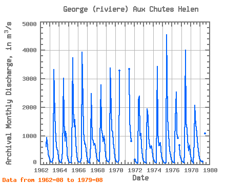
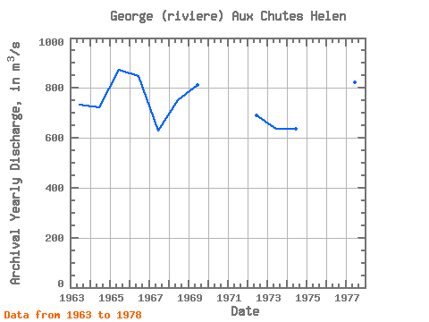
| Year | Jan | Feb | Mar | Apr | May | Jun | Jul | Aug | Sep | Oct | Nov | Dec | Annual | 1962 | 615.00 | 944.00 | 645.00 | 354.00 | 243.00 | 1963 | 127.00 | 89.50 | 74.30 | 87.50 | 261.00 | 3320.00 | 1760.00 | 1240.00 | 632.00 | 534.00 | 468.00 | 200.00 | 732.77 | 1964 | 116.00 | 84.70 | 71.00 | 73.80 | 455.00 | 3020.00 | 1500.00 | 821.00 | 1150.00 | 865.00 | 338.00 | 161.00 | 721.29 | 1965 | 97.40 | 71.60 | 59.70 | 56.30 | 481.00 | 3730.00 | 1890.00 | 1310.00 | 1560.00 | 751.00 | 295.00 | 150.00 | 871.00 | 1966 | 103.00 | 85.80 | 79.30 | 81.20 | 244.00 | 3940.00 | 2220.00 | 1130.00 | 707.00 | 746.00 | 531.00 | 313.00 | 848.36 | 1967 | 154.00 | 87.50 | 56.50 | 41.60 | 691.00 | 2480.00 | 888.00 | 813.00 | 675.00 | 721.00 | 616.00 | 313.00 | 628.05 | 1968 | 197.00 | 145.00 | 110.00 | 91.00 | 767.00 | 2780.00 | 1220.00 | 1040.00 | 789.00 | 990.00 | 619.00 | 274.00 | 751.83 | 1969 | 164.00 | 112.00 | 91.50 | 81.70 | 193.00 | 3370.00 | 1940.00 | 1210.00 | 1120.00 | 755.00 | 472.00 | 242.00 | 812.60 | 1970 | 135.00 | 105.00 | 85.40 | 74.50 | 137.00 | 3290.00 | 1971 | 3340.00 | 1520.00 | 1000.00 | 823.00 | 1972 | 167.00 | 107.00 | 72.90 | 49.50 | 40.50 | 2260.00 | 2390.00 | 1010.00 | 1080.00 | 657.00 | 278.00 | 155.00 | 688.91 | 1973 | 104.00 | 78.80 | 60.90 | 51.80 | 1940.00 | 1680.00 | 951.00 | 637.00 | 573.00 | 649.00 | 607.00 | 317.00 | 637.46 | 1974 | 190.00 | 121.00 | 79.70 | 55.50 | 59.80 | 3440.00 | 1110.00 | 656.00 | 673.00 | 769.00 | 304.00 | 189.00 | 637.25 | 1975 | 109.00 | 72.80 | 51.50 | 41.00 | 57.00 | 4550.00 | 1650.00 | 1310.00 | 752.00 | 485.00 | 309.00 | 175.00 | 796.86 | 1976 | 116.00 | 82.80 | 66.10 | 58.10 | 1530.00 | 2530.00 | 1070.00 | 929.00 | 665.00 | 328.00 | 204.00 | 1977 | 143.00 | 107.00 | 82.20 | 68.60 | 410.00 | 4010.00 | 1460.00 | 1220.00 | 839.00 | 477.00 | 678.00 | 381.00 | 822.98 | 1978 | 204.00 | 118.00 | 74.20 | 53.10 | 775.00 | 2070.00 | 1340.00 | 1300.00 | 847.00 | 631.00 | 344.00 | 212.00 | 664.02 | 1979 | 153.00 | 124.00 | 107.00 | 101.00 | 3560.00 | 2630.00 | 1080.00 | 596.00 |
|---|
 Return to R-Arctic Net Home Page