|
|
|||||||||||||||||
| Point ID: 5184 | Downloads | Plots | Site Data | Code: 03MD002 |
|
|
|||||||||||||||||
| Download | |
|---|---|
| Site Descriptor Information | Site Time Series Data |
| Link to all available data | |
|
|
| View: | Statistics | Time Series |
| Units: | mm |
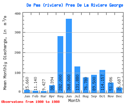
| Statistic | Jan | Feb | Mar | Apr | May | Jun | Jul | Aug | Sep | Oct | Nov | Dec | Annual |
|---|---|---|---|---|---|---|---|---|---|---|---|---|---|
| Mean | 15.66 | 11.14 | 9.43 | 38.39 | 282.00 | 368.00 | 131.88 | 76.78 | 89.50 | 114.16 | 51.09 | 26.69 | 94.80 |
| Standard Deviation | 5.63 | 3.95 | 3.50 | 50.35 | 104.03 | 219.22 | 32.16 | 28.70 | 32.12 | 60.63 | 29.49 | 11.01 | 16.24 |
| Min | 9.98 | 6.69 | 4.99 | 5.36 | 150.00 | 144.00 | 75.40 | 51.80 | 51.20 | 54.10 | 26.50 | 13.80 | 74.58 |
| Max | 27.10 | 19.50 | 15.90 | 143.00 | 403.00 | 720.00 | 155.00 | 126.00 | 134.00 | 216.00 | 114.00 | 43.20 | 109.98 |
| Coefficient of Variation | 0.36 | 0.35 | 0.37 | 1.31 | 0.37 | 0.60 | 0.24 | 0.37 | 0.36 | 0.53 | 0.58 | 0.41 | 0.17 |
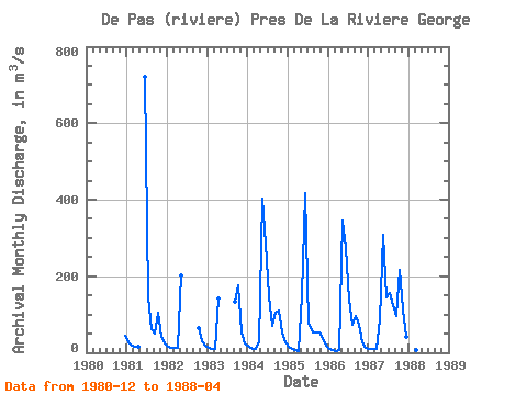
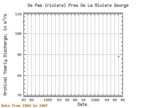
| Year | Jan | Feb | Mar | Apr | May | Jun | Jul | Aug | Sep | Oct | Nov | Dec | Annual | 1980 | 43.20 | 1981 | 27.10 | 19.50 | 15.90 | 16.40 | 720.00 | 144.00 | 62.90 | 51.20 | 104.00 | 41.20 | 24.90 | 1982 | 17.20 | 13.90 | 12.30 | 12.10 | 202.00 | 63.60 | 30.70 | 17.80 | 1983 | 11.90 | 9.63 | 8.98 | 143.00 | 134.00 | 176.00 | 53.10 | 24.80 | 1984 | 14.80 | 10.40 | 10.80 | 27.90 | 403.00 | 286.00 | 147.00 | 70.90 | 106.00 | 111.00 | 52.70 | 27.50 | 105.67 | 1985 | 14.90 | 9.07 | 6.31 | 5.36 | 150.00 | 417.00 | 75.40 | 51.80 | 52.90 | 54.10 | 39.40 | 18.70 | 74.58 | 1986 | 10.30 | 6.69 | 4.99 | 6.23 | 346.00 | 273.00 | 138.00 | 72.30 | 95.60 | 74.40 | 26.50 | 13.80 | 88.98 | 1987 | 9.98 | 8.93 | 8.62 | 88.10 | 309.00 | 144.00 | 155.00 | 126.00 | 97.30 | 216.00 | 114.00 | 42.80 | 109.98 | 1988 | 19.10 | 11.00 | 7.52 | 8.06 |
|---|
 Return to R-Arctic Net Home Page