|
|
|||||||||||||||||
| Point ID: 5176 | Downloads | Plots | Site Data | Code: 03LD004 |
|
|
|||||||||||||||||
| Download | |
|---|---|
| Site Descriptor Information | Site Time Series Data |
| Link to all available data | |
|
|
| View: | Statistics | Time Series |
| Units: | mm |
| Statistic | Jan | Feb | Mar | Apr | May | Jun | Jul | Aug | Sep | Oct | Nov | Dec | Annual |
|---|---|---|---|---|---|---|---|---|---|---|---|---|---|
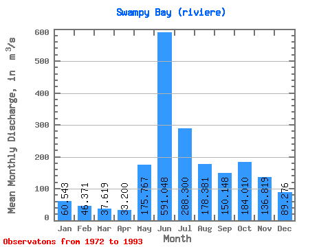
| Mean | 60.54 | 46.37 | 37.62 | 33.20 | 175.77 | 591.05 | 288.30 | 178.38 | 150.15 | 184.01 | 136.82 | 89.28 | 165.07 |
| Standard Deviation | 11.10 | 8.85 | 7.26 | 6.49 | 147.64 | 176.44 | 105.29 | 68.67 | 58.37 | 80.05 | 32.78 | 16.15 | 24.06 |
| Min | 44.80 | 31.00 | 24.70 | 21.70 | 31.30 | 391.00 | 140.00 | 80.40 | 63.10 | 77.80 | 92.60 | 68.50 | 107.71 |
| Max | 94.70 | 68.80 | 53.00 | 49.30 | 521.00 | 986.00 | 592.00 | 352.00 | 313.00 | 370.00 | 203.00 | 139.00 | 210.03 |
| Coefficient of Variation | 0.18 | 0.19 | 0.19 | 0.20 | 0.84 | 0.30 | 0.36 | 0.39 | 0.39 | 0.43 | 0.24 | 0.18 | 0.15 |
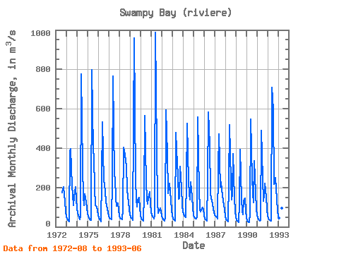
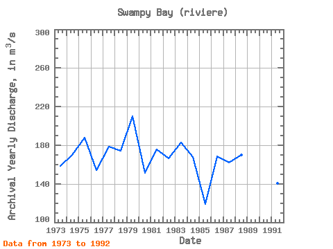
| Year | Jan | Feb | Mar | Apr | May | Jun | Jul | Aug | Sep | Oct | Nov | Dec | Annual | 1972 | 173.00 | 193.00 | 203.00 | 126.00 | 76.70 | 1973 | 51.80 | 39.60 | 31.30 | 27.40 | 384.00 | 396.00 | 207.00 | 162.00 | 111.00 | 152.00 | 203.00 | 139.00 | 158.68 | 1974 | 94.70 | 68.80 | 49.40 | 37.10 | 55.60 | 775.00 | 303.00 | 155.00 | 109.00 | 165.00 | 129.00 | 96.20 | 169.82 | 1975 | 68.70 | 50.50 | 38.40 | 32.60 | 34.80 | 796.00 | 392.00 | 352.00 | 197.00 | 111.00 | 103.00 | 80.30 | 188.03 | 1976 | 57.50 | 44.10 | 34.00 | 28.00 | 239.00 | 533.00 | 234.00 | 217.00 | 177.00 | 128.00 | 92.60 | 68.50 | 154.39 | 1977 | 54.50 | 46.00 | 39.80 | 36.10 | 240.00 | 767.00 | 259.00 | 250.00 | 142.00 | 106.00 | 119.00 | 85.70 | 178.76 | 1978 | 57.20 | 45.20 | 39.70 | 38.70 | 89.60 | 404.00 | 369.00 | 332.00 | 313.00 | 188.00 | 124.00 | 86.40 | 173.90 | 1979 | 61.60 | 47.60 | 39.50 | 35.20 | 521.00 | 958.00 | 241.00 | 137.00 | 101.00 | 137.00 | 147.00 | 94.40 | 210.03 | 1980 | 59.10 | 42.30 | 34.40 | 31.20 | 159.00 | 565.00 | 228.00 | 143.00 | 115.00 | 145.00 | 178.00 | 115.00 | 151.25 | 1981 | 78.60 | 59.30 | 46.90 | 41.30 | 57.10 | 986.00 | 398.00 | 122.00 | 70.20 | 77.80 | 95.50 | 75.40 | 175.68 | 1982 | 55.70 | 43.50 | 35.00 | 29.50 | 48.30 | 592.00 | 372.00 | 170.00 | 204.00 | 222.00 | 139.00 | 83.90 | 166.24 | 1983 | 56.10 | 42.20 | 33.20 | 31.10 | 478.00 | 391.00 | 261.00 | 143.00 | 145.00 | 308.00 | 198.00 | 111.00 | 183.13 | 1984 | 77.30 | 61.20 | 53.00 | 49.30 | 236.00 | 526.00 | 230.00 | 166.00 | 138.00 | 226.00 | 151.00 | 96.70 | 167.54 | 1985 | 59.00 | 47.50 | 41.80 | 39.60 | 52.20 | 559.00 | 189.00 | 89.60 | 75.80 | 84.40 | 100.00 | 88.20 | 118.84 | 1986 | 59.10 | 42.70 | 33.90 | 30.20 | 236.00 | 584.00 | 416.00 | 174.00 | 142.00 | 139.00 | 93.10 | 71.80 | 168.48 | 1987 | 59.10 | 57.20 | 48.90 | 41.30 | 292.00 | 470.00 | 203.00 | 226.00 | 187.00 | 159.00 | 111.00 | 87.10 | 161.80 | 1988 | 56.00 | 39.40 | 29.80 | 26.60 | 226.00 | 517.00 | 236.00 | 137.00 | 170.00 | 370.00 | 150.00 | 80.60 | 169.87 | 1989 | 49.80 | 35.60 | 27.90 | 24.60 | 116.00 | 393.00 | 140.00 | 80.40 | 63.10 | 136.00 | 146.00 | 80.10 | 107.71 | 1990 | 44.80 | 31.00 | 24.70 | 21.70 | 66.00 | 545.00 | 250.00 | 169.00 | 123.00 | 336.00 | 175.00 | 91.50 | 156.47 | 1991 | 59.80 | 44.60 | 35.80 | 30.50 | 34.40 | 489.00 | 246.00 | 130.00 | 158.00 | 222.00 | 152.00 | 86.10 | 140.68 | 1992 | 55.80 | 42.10 | 35.30 | 31.50 | 31.30 | 707.00 | 592.00 | 218.00 | 219.00 | 249.00 | 141.00 | 80.20 | 200.18 | 1993 | 55.20 | 43.40 | 37.30 | 33.70 | 94.80 | 459.00 |
|---|
 Return to R-Arctic Net Home Page