|
|
|||||||||||||||||
| Point ID: 5170 | Downloads | Plots | Site Data | Code: 03KA001 |
|
|
|||||||||||||||||
| Download | |
|---|---|
| Site Descriptor Information | Site Time Series Data |
| Link to all available data | |
|
|
| View: | Statistics | Time Series |
| Units: | mm |
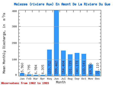
| Statistic | Jan | Feb | Mar | Apr | May | Jun | Jul | Aug | Sep | Oct | Nov | Dec | Annual |
|---|---|---|---|---|---|---|---|---|---|---|---|---|---|
| Mean | 15.96 | 9.79 | 6.98 | 6.30 | 159.75 | 399.46 | 154.40 | 131.74 | 140.17 | 133.54 | 69.90 | 31.11 | 106.65 |
| Standard Deviation | 3.82 | 2.75 | 2.32 | 2.23 | 108.01 | 118.57 | 51.48 | 81.66 | 56.51 | 32.66 | 19.11 | 7.97 | 14.17 |
| Min | 8.68 | 4.59 | 2.82 | 3.12 | 3.70 | 196.00 | 84.00 | 54.90 | 74.10 | 64.70 | 39.50 | 15.60 | 82.29 |
| Max | 22.30 | 14.80 | 11.80 | 12.10 | 351.00 | 673.00 | 263.00 | 403.00 | 308.00 | 201.00 | 113.00 | 44.50 | 135.88 |
| Coefficient of Variation | 0.24 | 0.28 | 0.33 | 0.35 | 0.68 | 0.30 | 0.33 | 0.62 | 0.40 | 0.24 | 0.27 | 0.26 | 0.13 |
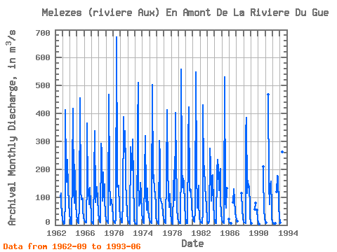
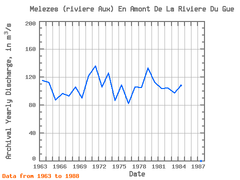
| Year | Jan | Feb | Mar | Apr | May | Jun | Jul | Aug | Sep | Oct | Nov | Dec | Annual | 1962 | 101.00 | 113.00 | 75.70 | 44.50 | 1963 | 19.20 | 8.14 | 3.76 | 5.24 | 85.70 | 413.00 | 204.00 | 155.00 | 234.00 | 131.00 | 79.90 | 40.80 | 114.98 | 1964 | 19.20 | 7.50 | 3.90 | 3.98 | 191.00 | 418.00 | 124.00 | 77.90 | 218.00 | 173.00 | 74.60 | 35.50 | 112.22 | 1965 | 16.90 | 9.51 | 6.42 | 5.02 | 73.30 | 455.00 | 122.00 | 91.20 | 96.30 | 91.10 | 49.00 | 28.10 | 86.99 | 1966 | 17.10 | 11.80 | 9.47 | 8.74 | 169.00 | 366.00 | 123.00 | 129.00 | 74.10 | 135.00 | 74.70 | 42.80 | 96.73 | 1967 | 16.50 | 8.44 | 5.49 | 4.64 | 181.00 | 338.00 | 88.60 | 80.70 | 120.00 | 137.00 | 94.10 | 42.80 | 93.11 | 1968 | 20.80 | 14.40 | 11.30 | 9.73 | 293.00 | 264.00 | 86.20 | 189.00 | 99.40 | 147.00 | 93.50 | 38.60 | 105.58 | 1969 | 22.30 | 14.80 | 10.40 | 6.64 | 54.50 | 468.00 | 167.00 | 72.40 | 82.30 | 92.10 | 57.90 | 34.80 | 90.26 | 1970 | 20.90 | 13.60 | 9.28 | 6.93 | 21.50 | 673.00 | 204.00 | 137.00 | 137.00 | 142.00 | 63.00 | 30.80 | 121.58 | 1971 | 18.30 | 12.60 | 9.84 | 9.36 | 87.80 | 387.00 | 263.00 | 337.00 | 212.00 | 155.00 | 97.10 | 41.50 | 135.88 | 1972 | 19.40 | 10.10 | 5.84 | 3.70 | 3.70 | 281.00 | 234.00 | 198.00 | 308.00 | 153.00 | 39.50 | 15.60 | 105.99 | 1973 | 8.88 | 6.21 | 4.95 | 4.44 | 351.00 | 511.00 | 174.00 | 69.40 | 74.70 | 151.00 | 113.00 | 42.10 | 125.89 | 1974 | 21.00 | 12.30 | 7.54 | 5.08 | 184.00 | 320.00 | 108.00 | 54.90 | 132.00 | 114.00 | 53.10 | 28.40 | 86.69 | 1975 | 18.30 | 12.10 | 8.49 | 6.47 | 79.50 | 502.00 | 167.00 | 180.00 | 119.00 | 119.00 | 65.10 | 28.50 | 108.79 | 1976 | 16.80 | 10.60 | 6.67 | 4.43 | 303.00 | 241.00 | 98.30 | 88.00 | 80.00 | 72.80 | 41.60 | 24.30 | 82.29 | 1977 | 16.20 | 11.50 | 8.18 | 6.17 | 178.00 | 412.00 | 176.00 | 140.00 | 104.00 | 64.70 | 112.00 | 41.70 | 105.87 | 1978 | 15.60 | 7.44 | 4.34 | 3.15 | 125.00 | 196.00 | 90.00 | 403.00 | 204.00 | 126.00 | 56.50 | 26.90 | 104.83 | 1979 | 14.80 | 9.62 | 6.96 | 5.61 | 229.00 | 559.00 | 223.00 | 133.00 | 168.00 | 151.00 | 72.80 | 25.10 | 133.16 | 1980 | 11.80 | 7.50 | 5.97 | 5.58 | 301.00 | 423.00 | 127.00 | 118.00 | 128.00 | 126.00 | 68.40 | 35.60 | 113.15 | 1981 | 20.80 | 14.60 | 11.80 | 10.60 | 53.40 | 548.00 | 200.00 | 60.50 | 74.60 | 143.00 | 80.00 | 26.50 | 103.65 | 1982 | 13.30 | 9.16 | 7.53 | 7.08 | 46.70 | 430.00 | 192.00 | 213.00 | 131.00 | 110.00 | 58.90 | 29.30 | 104.00 | 1983 | 15.70 | 9.53 | 6.60 | 12.10 | 274.00 | 214.00 | 143.00 | 85.80 | 124.00 | 179.00 | 77.70 | 27.50 | 97.41 | 1984 | 12.10 | 7.00 | 5.14 | 5.90 | 195.00 | 235.00 | 202.00 | 123.00 | 178.00 | 201.00 | 92.60 | 38.90 | 107.97 | 1985 | 18.90 | 11.10 | 7.80 | 6.58 | 72.20 | 531.00 | 84.00 | 61.70 | 131.00 | 21.10 | 1986 | 11.70 | 8.33 | 6.75 | 6.47 | 81.20 | 128.00 | 89.00 | 46.80 | 28.30 | 1987 | 18.50 | 13.00 | 114.00 | 57.10 | 24.10 | 1988 | 12.50 | 8.74 | 7.54 | 7.43 | 331.00 | 384.00 | 114.00 | 159.00 | 135.00 | 138.00 | 66.10 | 27.10 | 115.87 | 1989 | 11.80 | 6.09 | 57.20 | 78.80 | 53.70 | 19.60 | 1990 | 8.68 | 4.59 | 2.82 | 210.00 | 174.00 | 56.60 | 23.50 | 1991 | 12.30 | 8.35 | 467.00 | 146.00 | 73.80 | 145.00 | 156.00 | 60.70 | 22.80 | 1992 | 10.40 | 5.80 | 3.83 | 3.12 | 7.26 | 120.00 | 178.00 | 175.00 | 65.30 | 27.30 | 1993 | 14.10 | 9.18 | 6.95 | 6.04 | 263.00 | 350.00 |
|---|
 Return to R-Arctic Net Home Page