|
|
|||||||||||||||||
| Point ID: 5165 | Downloads | Plots | Site Data | Other Close Sites | Code: 03HB004 |
|
|
|||||||||||||||||
| Download | |
|---|---|
| Site Descriptor Information | Site Time Series Data |
| Link to all available data | |
|
|
| View: | Statistics | Time Series |
| Units: | mm |
| Statistic | Jan | Feb | Mar | Apr | May | Jun | Jul | Aug | Sep | Oct | Nov | Dec | Annual |
|---|---|---|---|---|---|---|---|---|---|---|---|---|---|
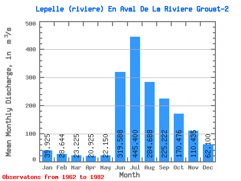
| Mean | 39.92 | 28.64 | 23.23 | 20.93 | 22.15 | 319.59 | 445.40 | 284.69 | 225.22 | 170.48 | 110.44 | 62.10 | 146.22 |
| Standard Deviation | 11.08 | 8.42 | 7.38 | 6.93 | 8.60 | 148.66 | 132.88 | 85.94 | 71.16 | 51.01 | 39.97 | 19.08 | 37.99 |
| Min | 25.80 | 18.50 | 13.30 | 11.20 | 10.30 | 98.40 | 269.00 | 184.00 | 144.00 | 94.10 | 72.00 | 38.70 | 104.80 |
| Max | 65.40 | 53.00 | 45.00 | 41.30 | 48.30 | 599.00 | 664.00 | 539.00 | 426.00 | 279.00 | 212.00 | 98.40 | 252.17 |
| Coefficient of Variation | 0.28 | 0.29 | 0.32 | 0.33 | 0.39 | 0.47 | 0.30 | 0.30 | 0.32 | 0.30 | 0.36 | 0.31 | 0.26 |
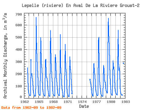
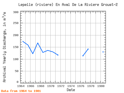
| Year | Jan | Feb | Mar | Apr | May | Jun | Jul | Aug | Sep | Oct | Nov | Dec | Annual | 1962 | 250.00 | 161.00 | 82.10 | 50.90 | 1963 | 31.50 | 24.60 | 22.60 | 21.90 | 27.10 | 315.00 | 199.00 | 173.00 | 128.00 | 78.90 | 49.60 | 1964 | 29.30 | 21.00 | 17.50 | 17.40 | 18.30 | 128.00 | 664.00 | 385.00 | 345.00 | 250.00 | 144.00 | 59.50 | 173.25 | 1965 | 34.20 | 27.60 | 24.20 | 22.90 | 23.20 | 499.00 | 445.00 | 293.00 | 237.00 | 172.00 | 81.70 | 46.00 | 158.82 | 1966 | 35.00 | 26.60 | 20.60 | 17.30 | 18.40 | 310.00 | 321.00 | 184.00 | 169.00 | 159.00 | 120.00 | 80.60 | 121.79 | 1967 | 49.10 | 26.20 | 18.40 | 16.30 | 16.00 | 382.00 | 556.00 | 308.00 | 257.00 | 179.00 | 120.00 | 73.70 | 166.81 | 1968 | 39.30 | 26.30 | 20.90 | 18.80 | 18.30 | 315.00 | 358.00 | 269.00 | 180.00 | 148.00 | 88.50 | 47.80 | 127.49 | 1969 | 34.00 | 28.00 | 24.20 | 21.40 | 22.10 | 259.00 | 524.00 | 271.00 | 183.00 | 129.00 | 81.10 | 55.80 | 136.05 | 1970 | 31.70 | 18.50 | 13.30 | 11.20 | 10.30 | 98.40 | 443.00 | 329.00 | 249.00 | 205.00 | 98.40 | 48.60 | 129.70 | 1971 | 30.80 | 21.90 | 16.80 | 14.70 | 14.70 | 184.00 | 341.00 | 234.00 | 234.00 | 180.00 | 87.20 | 38.70 | 116.48 | 1975 | 154.00 | 130.00 | 127.00 | 81.40 | 1976 | 51.50 | 33.10 | 22.60 | 16.90 | 17.20 | 279.00 | 286.00 | 211.00 | 186.00 | 130.00 | 74.60 | 47.80 | 112.97 | 1977 | 33.70 | 26.60 | 22.80 | 21.30 | 26.70 | 473.00 | 500.00 | 241.00 | 144.00 | 94.10 | 72.00 | 38.80 | 141.17 | 1978 | 25.80 | 20.10 | 17.30 | 16.30 | 16.20 | 148.00 | 269.00 | 237.00 | 154.00 | 135.00 | 131.00 | 87.90 | 104.80 | 1979 | 65.40 | 53.00 | 45.00 | 41.30 | 48.30 | 599.00 | 656.00 | 539.00 | 426.00 | 279.00 | 185.00 | 89.00 | 252.17 | 1980 | 48.50 | 32.00 | 25.40 | 23.40 | 26.30 | 307.00 | 275.00 | 243.00 | 257.00 | 162.00 | 93.90 | 61.20 | 129.56 | 1981 | 44.40 | 35.90 | 30.80 | 27.90 | 26.10 | 269.00 | 557.00 | 325.00 | 229.00 | 257.00 | 212.00 | 98.40 | 176.04 | 1982 | 54.60 | 36.90 | 29.20 | 25.80 | 25.20 | 548.00 | 486.00 | 287.00 | 227.00 |
|---|
| Other Close Sites | ||||||
|---|---|---|---|---|---|---|
| PointID | Latitude | Longitude | Drainage Area | Source | Name | |
| 5166 | "LEPELLE (RIVIERE) EN AVAL DE LA RIVIERE GROUST-1" | 60.19 | -976308 | Hydat | ||
 Return to R-Arctic Net Home Page