|
|
|||||||||||||||||
| Point ID: 5146 | Downloads | Plots | Site Data | Code: 03FB001 |
|
|
|||||||||||||||||
| Download | |
|---|---|
| Site Descriptor Information | Site Time Series Data |
| Link to all available data | |
|
|
| View: | Statistics | Time Series |
| Units: | mm |
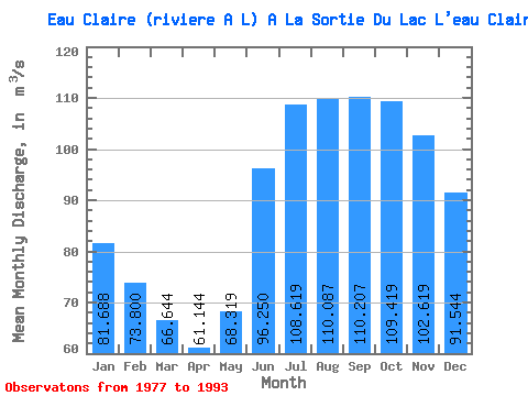
| Statistic | Jan | Feb | Mar | Apr | May | Jun | Jul | Aug | Sep | Oct | Nov | Dec | Annual |
|---|---|---|---|---|---|---|---|---|---|---|---|---|---|
| Mean | 81.69 | 73.80 | 66.64 | 61.14 | 68.32 | 96.25 | 108.62 | 110.09 | 110.21 | 109.42 | 102.62 | 91.54 | 90.10 |
| Standard Deviation | 13.86 | 13.53 | 12.77 | 12.09 | 14.17 | 15.07 | 18.35 | 18.85 | 18.29 | 18.28 | 16.42 | 14.62 | 12.80 |
| Min | 53.70 | 49.50 | 38.40 | 31.50 | 32.30 | 69.10 | 71.90 | 64.20 | 53.10 | 61.00 | 59.20 | 57.30 | 54.31 |
| Max | 109.00 | 98.70 | 87.10 | 80.60 | 86.40 | 118.00 | 132.00 | 145.00 | 136.00 | 143.00 | 131.00 | 120.00 | 104.44 |
| Coefficient of Variation | 0.17 | 0.18 | 0.19 | 0.20 | 0.21 | 0.16 | 0.17 | 0.17 | 0.17 | 0.17 | 0.16 | 0.16 | 0.14 |
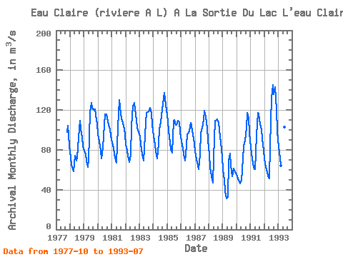
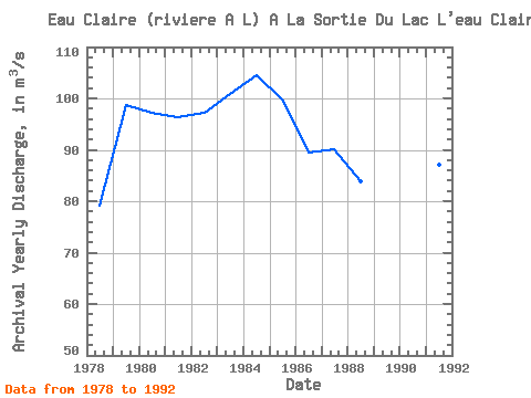
| Year | Jan | Feb | Mar | Apr | May | Jun | Jul | Aug | Sep | Oct | Nov | Dec | Annual | 1977 | 97.70 | 104.00 | 84.20 | 1978 | 72.00 | 64.80 | 60.70 | 58.50 | 74.50 | 69.10 | 71.90 | 92.20 | 109.00 | 101.00 | 93.10 | 83.30 | 79.17 | 1979 | 79.30 | 75.30 | 68.90 | 62.60 | 69.80 | 118.00 | 127.00 | 122.00 | 120.00 | 121.00 | 115.00 | 106.00 | 98.74 | 1980 | 95.90 | 88.70 | 79.00 | 71.10 | 82.40 | 105.00 | 116.00 | 116.00 | 112.00 | 105.00 | 101.00 | 94.40 | 97.21 | 1981 | 87.00 | 81.20 | 75.70 | 69.30 | 67.20 | 103.00 | 130.00 | 123.00 | 111.00 | 109.00 | 104.00 | 95.50 | 96.33 | 1982 | 84.90 | 80.10 | 73.40 | 68.10 | 75.20 | 104.00 | 124.00 | 127.00 | 121.00 | 110.00 | 102.00 | 97.70 | 97.28 | 1983 | 93.50 | 85.80 | 75.40 | 68.90 | 81.20 | 107.00 | 117.00 | 118.00 | 119.00 | 122.00 | 117.00 | 105.00 | 100.82 | 1984 | 94.40 | 85.20 | 78.70 | 71.60 | 86.40 | 101.00 | 108.00 | 114.00 | 126.00 | 137.00 | 131.00 | 120.00 | 104.44 | 1985 | 109.00 | 98.70 | 87.10 | 80.60 | 77.10 | 109.00 | 110.00 | 105.00 | 105.00 | 109.00 | 108.00 | 97.70 | 99.68 | 1986 | 88.70 | 81.30 | 75.50 | 69.30 | 74.90 | 95.60 | 97.30 | 98.30 | 107.00 | 104.00 | 94.80 | 86.20 | 89.41 | 1987 | 78.30 | 70.50 | 64.30 | 60.30 | 75.70 | 97.20 | 102.00 | 110.00 | 119.00 | 113.00 | 102.00 | 89.80 | 90.17 | 1988 | 75.00 | 62.90 | 53.10 | 47.20 | 72.20 | 109.00 | 109.00 | 111.00 | 107.00 | 100.00 | 87.30 | 72.80 | 83.88 | 1989 | 59.80 | 49.50 | 38.40 | 31.50 | 32.30 | 69.30 | 76.10 | 64.20 | 53.10 | 61.00 | 59.20 | 57.30 | 54.31 | 1990 | 53.70 | 50.50 | 48.30 | 46.50 | 49.40 | 71.20 | 83.60 | 89.60 | 102.00 | 117.00 | 112.00 | 96.80 | 76.72 | 1991 | 81.90 | 71.60 | 65.60 | 60.90 | 60.80 | 94.50 | 117.00 | 116.00 | 106.00 | 101.00 | 90.50 | 79.30 | 87.09 | 1992 | 70.50 | 62.70 | 57.80 | 53.30 | 50.90 | 84.10 | 132.00 | 145.00 | 136.00 | 143.00 | 121.00 | 98.70 | 96.25 | 1993 | 83.10 | 72.00 | 64.40 | 58.60 | 63.10 | 103.00 | 117.00 |
|---|
 Return to R-Arctic Net Home Page