|
|
|||||||||||||||||
| Point ID: 5141 | Downloads | Plots | Site Data | Code: 03EE001 |
|
|
|||||||||||||||||
| Download | |
|---|---|
| Site Descriptor Information | Site Time Series Data |
| Link to all available data | |
|

|
| View: | Statistics | Time Series |
| Units: | mm |
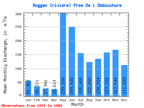
| Statistic | Jan | Feb | Mar | Apr | May | Jun | Jul | Aug | Sep | Oct | Nov | Dec | Annual |
|---|---|---|---|---|---|---|---|---|---|---|---|---|---|
| Mean | 55.96 | 36.31 | 27.99 | 26.61 | 299.50 | 249.50 | 155.00 | 122.65 | 134.91 | 157.22 | 167.54 | 111.83 | 127.75 |
| Standard Deviation | 11.64 | 9.37 | 8.91 | 8.91 | 99.38 | 81.59 | 63.42 | 78.86 | 47.44 | 34.22 | 58.63 | 49.04 | 14.47 |
| Min | 35.90 | 23.60 | 17.60 | 15.80 | 200.00 | 164.00 | 80.00 | 50.30 | 79.70 | 91.00 | 77.30 | 48.70 | 107.64 |
| Max | 68.80 | 50.10 | 42.80 | 39.60 | 457.00 | 359.00 | 271.00 | 242.00 | 215.00 | 194.00 | 268.00 | 199.00 | 151.15 |
| Coefficient of Variation | 0.21 | 0.26 | 0.32 | 0.34 | 0.33 | 0.33 | 0.41 | 0.64 | 0.35 | 0.22 | 0.35 | 0.44 | 0.11 |
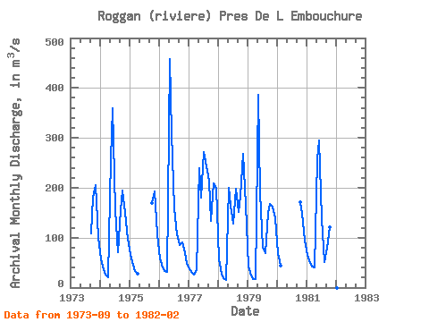
| Year | Jan | Feb | Mar | Apr | May | Jun | Jul | Aug | Sep | Oct | Nov | Dec | Annual | 1973 | 108.00 | 181.00 | 206.00 | 101.00 | 1974 | 56.80 | 37.20 | 25.70 | 21.10 | 257.00 | 359.00 | 155.00 | 70.00 | 155.00 | 194.00 | 149.00 | 98.10 | 131.49 | 1975 | 65.30 | 45.70 | 33.10 | 27.30 | 170.00 | 192.00 | 106.00 | 1976 | 58.10 | 39.70 | 32.30 | 30.60 | 457.00 | 309.00 | 158.00 | 107.00 | 85.70 | 91.00 | 77.30 | 48.70 | 124.53 | 1977 | 35.90 | 29.30 | 26.20 | 34.40 | 239.00 | 180.00 | 271.00 | 242.00 | 215.00 | 134.00 | 208.00 | 199.00 | 151.15 | 1978 | 56.70 | 27.00 | 18.20 | 15.80 | 200.00 | 164.00 | 128.00 | 198.00 | 152.00 | 184.00 | 268.00 | 166.00 | 131.47 | 1979 | 41.40 | 23.60 | 17.60 | 17.50 | 386.00 | 190.00 | 80.00 | 68.60 | 149.00 | 168.00 | 162.00 | 139.00 | 120.22 | 1980 | 68.80 | 44.60 | 172.00 | 147.00 | 94.80 | 1981 | 64.70 | 50.10 | 42.80 | 39.60 | 258.00 | 295.00 | 138.00 | 50.30 | 79.70 | 121.00 | 98.60 | 53.90 | 107.64 | 1982 | 29.60 |
|---|
 Return to R-Arctic Net Home Page