|
|
|||||||||||||||||
| Point ID: 5139 | Downloads | Plots | Site Data | Other Close Sites | Code: 03ED003 |
|
|
|||||||||||||||||
| Download | |
|---|---|
| Site Descriptor Information | Site Time Series Data |
| Link to all available data | |
|
|
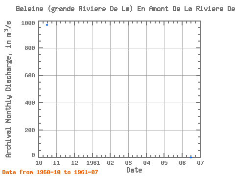
| View: | Statistics | Time Series |
| Units: | mm |
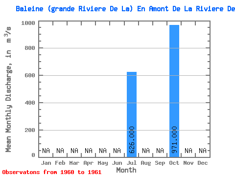
| Statistic | Jan | Feb | Mar | Apr | May | Jun | Jul | Aug | Sep | Oct | Nov | Dec | Annual |
|---|---|---|---|---|---|---|---|---|---|---|---|---|---|
| Mean | 626.00 | 971.00 | |||||||||||
| Standard Deviation | |||||||||||||
| Min | 626.00 | 971.00 | |||||||||||
| Max | 626.00 | 971.00 | |||||||||||
| Coefficient of Variation |
| Year | Jan | Feb | Mar | Apr | May | Jun | Jul | Aug | Sep | Oct | Nov | Dec | Annual | 1960 | 971.00 | 1961 | 626.00 |
|---|
| Other Close Sites | ||||||
|---|---|---|---|---|---|---|
| PointID | Latitude | Longitude | Drainage Area | Source | Name | |
| 5137 | "BALEINE (GRANDE RIVIERE DE LA) EN AMONT DE LA RIVIERE DENYS-1" | 55.23 | -857111 | Hydat | ||
 Return to R-Arctic Net Home Page