|
|
|||||||||||||||||
| Point ID: 5134 | Downloads | Plots | Site Data | Code: 03EA002 |
|
|
|||||||||||||||||
| Download | |
|---|---|
| Site Descriptor Information | Site Time Series Data |
| Link to all available data | |
|

|
| View: | Statistics | Time Series |
| Units: | mm |
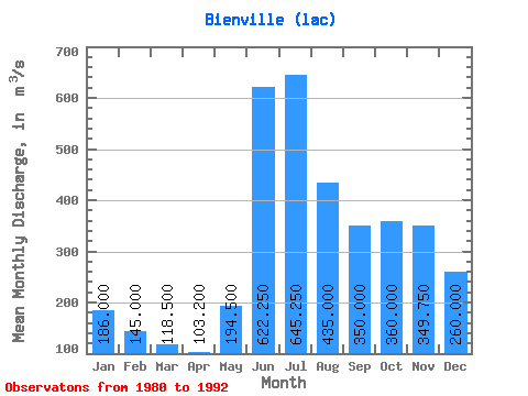
| Statistic | Jan | Feb | Mar | Apr | May | Jun | Jul | Aug | Sep | Oct | Nov | Dec | Annual |
|---|---|---|---|---|---|---|---|---|---|---|---|---|---|
| Mean | 186.00 | 145.00 | 118.50 | 103.20 | 194.50 | 622.25 | 645.25 | 435.00 | 350.00 | 360.00 | 349.75 | 260.00 | 295.25 |
| Standard Deviation | 13.90 | 6.27 | 9.26 | 8.05 | 115.52 | 70.63 | 205.55 | 92.49 | 69.11 | 49.70 | 56.32 | 23.12 | 1.18 |
| Min | 167.00 | 138.00 | 111.00 | 96.90 | 106.00 | 542.00 | 432.00 | 367.00 | 267.00 | 308.00 | 298.00 | 227.00 | 294.42 |
| Max | 199.00 | 153.00 | 131.00 | 115.00 | 363.00 | 686.00 | 923.00 | 567.00 | 436.00 | 404.00 | 411.00 | 281.00 | 296.08 |
| Coefficient of Variation | 0.07 | 0.04 | 0.08 | 0.08 | 0.59 | 0.11 | 0.32 | 0.21 | 0.20 | 0.14 | 0.16 | 0.09 | 0.00 |
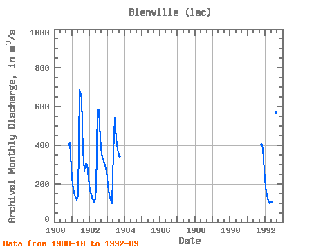
| Year | Jan | Feb | Mar | Apr | May | Jun | Jul | Aug | Sep | Oct | Nov | Dec | Annual | 1980 | 401.00 | 411.00 | 281.00 | 1981 | 199.00 | 153.00 | 131.00 | 115.00 | 137.00 | 686.00 | 645.00 | 367.00 | 267.00 | 308.00 | 298.00 | 227.00 | 294.42 | 1982 | 167.00 | 146.00 | 120.00 | 101.00 | 172.00 | 584.00 | 581.00 | 431.00 | 353.00 | 327.00 | 306.00 | 265.00 | 296.08 | 1983 | 193.00 | 143.00 | 112.00 | 99.90 | 363.00 | 542.00 | 432.00 | 375.00 | 344.00 | 1991 | 404.00 | 384.00 | 267.00 | 1992 | 185.00 | 138.00 | 111.00 | 96.90 | 106.00 | 677.00 | 923.00 | 567.00 | 436.00 |
|---|
 Return to R-Arctic Net Home Page