|
|
|||||||||||||||||
| Point ID: 5133 | Downloads | Plots | Site Data | Code: 03EA001 |
|
|
|||||||||||||||||
| Download | |
|---|---|
| Site Descriptor Information | Site Time Series Data |
| Link to all available data | |
|
|
| View: | Statistics | Time Series |
| Units: | mm |
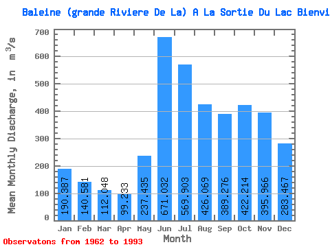
| Statistic | Jan | Feb | Mar | Apr | May | Jun | Jul | Aug | Sep | Oct | Nov | Dec | Annual |
|---|---|---|---|---|---|---|---|---|---|---|---|---|---|
| Mean | 190.39 | 140.58 | 112.05 | 99.23 | 237.44 | 671.03 | 569.90 | 426.07 | 389.28 | 422.21 | 395.97 | 283.47 | 335.97 |
| Standard Deviation | 30.27 | 22.97 | 19.52 | 18.08 | 118.72 | 185.05 | 163.26 | 136.79 | 127.39 | 88.71 | 91.28 | 54.78 | 47.27 |
| Min | 137.00 | 100.00 | 78.50 | 63.50 | 80.70 | 351.00 | 345.00 | 211.00 | 168.00 | 218.00 | 239.00 | 177.00 | 220.00 |
| Max | 254.00 | 193.00 | 161.00 | 151.00 | 600.00 | 1170.00 | 1040.00 | 838.00 | 700.00 | 579.00 | 612.00 | 402.00 | 436.59 |
| Coefficient of Variation | 0.16 | 0.16 | 0.17 | 0.18 | 0.50 | 0.28 | 0.29 | 0.32 | 0.33 | 0.21 | 0.23 | 0.19 | 0.14 |
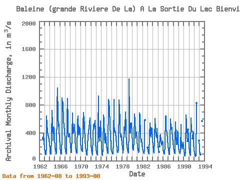
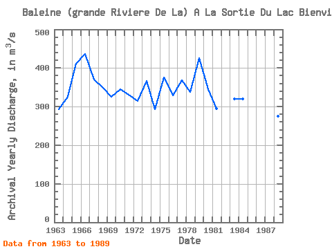
| Year | Jan | Feb | Mar | Apr | May | Jun | Jul | Aug | Sep | Oct | Nov | Dec | Annual | 1962 | 325.00 | 296.00 | 384.00 | 359.00 | 273.00 | 1963 | 178.00 | 122.00 | 92.50 | 86.80 | 210.00 | 638.00 | 517.00 | 417.00 | 372.00 | 344.00 | 297.00 | 249.00 | 293.61 | 1964 | 168.00 | 117.00 | 94.50 | 95.20 | 335.00 | 724.00 | 523.00 | 299.00 | 293.00 | 485.00 | 461.00 | 307.00 | 325.14 | 1965 | 205.00 | 148.00 | 116.00 | 99.90 | 121.00 | 784.00 | 1040.00 | 645.00 | 488.00 | 528.00 | 434.00 | 328.00 | 411.41 | 1966 | 201.00 | 127.00 | 99.60 | 94.50 | 360.00 | 903.00 | 818.00 | 838.00 | 565.00 | 503.00 | 422.00 | 308.00 | 436.59 | 1967 | 200.00 | 145.00 | 113.00 | 95.40 | 600.00 | 890.00 | 561.00 | 440.00 | 343.00 | 366.00 | 387.00 | 301.00 | 370.12 | 1968 | 208.00 | 149.00 | 118.00 | 115.00 | 360.00 | 684.00 | 390.00 | 403.00 | 466.00 | 491.00 | 518.00 | 308.00 | 350.83 | 1969 | 197.00 | 143.00 | 114.00 | 108.00 | 110.00 | 562.00 | 645.00 | 393.00 | 366.00 | 482.00 | 442.00 | 334.00 | 324.67 | 1970 | 246.00 | 193.00 | 156.00 | 137.00 | 135.00 | 519.00 | 689.00 | 458.00 | 632.00 | 475.00 | 301.00 | 195.00 | 344.67 | 1971 | 137.00 | 108.00 | 89.80 | 85.70 | 218.00 | 357.00 | 395.00 | 495.00 | 521.00 | 544.00 | 612.00 | 402.00 | 330.38 | 1972 | 230.00 | 157.00 | 120.00 | 93.20 | 80.70 | 354.00 | 517.00 | 464.00 | 509.00 | 579.00 | 422.00 | 252.00 | 314.82 | 1973 | 161.00 | 117.00 | 96.30 | 85.60 | 441.00 | 927.00 | 583.00 | 371.00 | 286.00 | 395.00 | 572.00 | 367.00 | 366.82 | 1974 | 183.00 | 124.00 | 90.80 | 77.20 | 179.00 | 658.00 | 590.00 | 329.00 | 255.00 | 350.00 | 390.00 | 293.00 | 293.25 | 1975 | 215.00 | 163.00 | 124.00 | 107.00 | 150.00 | 881.00 | 844.00 | 738.00 | 523.00 | 336.00 | 239.00 | 177.00 | 374.75 | 1976 | 141.00 | 119.00 | 103.00 | 94.60 | 279.00 | 879.00 | 533.00 | 412.00 | 433.00 | 399.00 | 322.00 | 234.00 | 329.05 | 1977 | 179.00 | 146.00 | 127.00 | 119.00 | 160.00 | 871.00 | 741.00 | 593.00 | 441.00 | 343.00 | 374.00 | 332.00 | 368.83 | 1978 | 241.00 | 180.00 | 137.00 | 108.00 | 189.00 | 482.00 | 389.00 | 478.00 | 700.00 | 493.00 | 380.00 | 271.00 | 337.33 | 1979 | 197.00 | 153.00 | 125.00 | 108.00 | 426.00 | 1170.00 | 660.00 | 402.00 | 399.00 | 541.00 | 542.00 | 380.00 | 425.25 | 1980 | 254.00 | 193.00 | 161.00 | 151.00 | 303.00 | 673.00 | 573.00 | 406.00 | 323.00 | 401.00 | 411.00 | 281.00 | 344.17 | 1981 | 199.00 | 153.00 | 131.00 | 115.00 | 137.00 | 686.00 | 645.00 | 367.00 | 267.00 | 308.00 | 298.00 | 227.00 | 294.42 | 1982 | 167.00 | 146.00 | 120.00 | 101.00 | 172.00 | 584.00 | 581.00 | 1983 | 193.00 | 143.00 | 112.00 | 99.90 | 363.00 | 542.00 | 432.00 | 375.00 | 344.00 | 467.00 | 458.00 | 308.00 | 319.74 | 1984 | 201.00 | 151.00 | 123.00 | 110.00 | 299.00 | 609.00 | 452.00 | 365.00 | 333.00 | 461.00 | 420.00 | 316.00 | 320.00 | 1985 | 215.00 | 159.00 | 128.00 | 203.00 | 351.00 | 379.00 | 273.00 | 227.00 | 245.00 | 286.00 | 241.00 | 1986 | 162.00 | 125.00 | 104.00 | 93.50 | 219.00 | 640.00 | 645.00 | 453.00 | 420.00 | 414.00 | 302.00 | 208.00 | 315.46 | 1987 | 153.00 | 117.00 | 94.60 | 88.90 | 281.00 | 597.00 | 458.00 | 465.00 | 480.00 | 423.00 | 335.00 | 269.00 | 313.46 | 1988 | 193.00 | 140.00 | 111.00 | 105.00 | 275.00 | 558.00 | 345.00 | 235.00 | 236.00 | 430.00 | 392.00 | 275.00 | 274.58 | 1989 | 188.00 | 143.00 | 116.00 | 102.00 | 154.00 | 517.00 | 357.00 | 211.00 | 168.00 | 218.00 | 265.00 | 201.00 | 220.00 | 1990 | 138.00 | 100.00 | 78.50 | 68.50 | 140.00 | 658.00 | 542.00 | 339.00 | 284.00 | 451.00 | 333.00 | 1991 | 206.00 | 134.00 | 94.60 | 77.10 | 189.00 | 611.00 | 423.00 | 319.00 | 417.00 | 391.00 | 243.00 | 1992 | 155.00 | 108.00 | 80.30 | 63.50 | 84.80 | 683.00 | 830.00 | 291.00 | 1993 | 191.00 | 135.00 | 103.00 | 91.50 | 187.00 | 810.00 | 570.00 | 367.00 |
|---|
 Return to R-Arctic Net Home Page