|
|
|||||||||||||||||
| Point ID: 5130 | Downloads | Plots | Site Data | Other Close Sites | Code: 03DE007 |
|
|
|||||||||||||||||
| Download | |
|---|---|
| Site Descriptor Information | Site Time Series Data |
| Link to all available data | |
|
|
| View: | Statistics | Time Series |
| Units: | mm |
| Statistic | Jan | Feb | Mar | Apr | May | Jun | Jul | Aug | Sep | Oct | Nov | Dec | Annual |
|---|---|---|---|---|---|---|---|---|---|---|---|---|---|
| Mean | 32.85 | 22.50 | 19.70 | 20.20 | 109.25 | 122.00 | 67.60 | 53.70 | 52.40 | 108.00 | 70.10 | 48.20 | 63.74 |
| Standard Deviation | 4.74 | 3.54 | 1.98 | 2.12 | 56.22 | 6.22 | |||||||
| Min | 29.50 | 20.00 | 18.30 | 18.70 | 69.50 | 122.00 | 67.60 | 53.70 | 52.40 | 108.00 | 70.10 | 43.80 | 63.74 |
| Max | 36.20 | 25.00 | 21.10 | 21.70 | 149.00 | 122.00 | 67.60 | 53.70 | 52.40 | 108.00 | 70.10 | 52.60 | 63.74 |
| Coefficient of Variation | 0.14 | 0.16 | 0.10 | 0.10 | 0.52 | 0.13 |
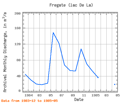
| Year | Jan | Feb | Mar | Apr | May | Jun | Jul | Aug | Sep | Oct | Nov | Dec | Annual | 1983 | 43.80 | 1984 | 29.50 | 20.00 | 18.30 | 21.70 | 149.00 | 122.00 | 67.60 | 53.70 | 52.40 | 108.00 | 70.10 | 52.60 | 63.74 | 1985 | 36.20 | 25.00 | 21.10 | 18.70 | 69.50 |
|---|
| Other Close Sites | ||||||
|---|---|---|---|---|---|---|
| PointID | Latitude | Longitude | Drainage Area | Source | Name | |
| 5121 | "MASTA (CHENAL) EN AVAL DE LA RIVIERE DE PONTOIS" | 53.25 | -1065352 | Hydat | ||
| 5122 | "DE PONTOIS (RIVIERE) EN AMONT DE LA RIVIERE SAKAMI" | 53.16 | -1078030 | Hydat | ||
| 5124 | "MASTA (CHENAL) EN AVAL DE LA RIVIERE DE PONTOIS-1" | 53.24 | -1064956 | Hydat | ||
| 5125 | "DE PONTOIS (RIVIERE) EN AVAL DE LA RIVIERE SAKAMI" | 53.28 | -1056405 | Hydat | ||
| 5128 | "SAKAMI (RIVIERE) EN AVAL DE LA RIVIERE DE PONTOIS-1" | 53.25 | -1053856 | Hydat | ||
| 5129 | "SAKAMI (RIVIERE) EN AVAL DE LA RIVIERE DE PONTOIS-2" | 53.25 | -1053856 | Hydat | ||
 Return to R-Arctic Net Home Page
