|
|
|||||||||||||||||
| Point ID: 5117 | Downloads | Plots | Site Data | Other Close Sites | Code: 03DC002 |
|
|
|||||||||||||||||
| Download | |
|---|---|
| Site Descriptor Information | Site Time Series Data |
| Link to all available data | |
|
|
| View: | Statistics | Time Series |
| Units: | mm |
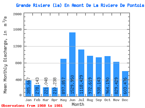
| Statistic | Jan | Feb | Mar | Apr | May | Jun | Jul | Aug | Sep | Oct | Nov | Dec | Annual |
|---|---|---|---|---|---|---|---|---|---|---|---|---|---|
| Mean | 385.67 | 278.14 | 221.05 | 210.24 | 897.86 | 1529.95 | 1118.43 | 972.62 | 938.14 | 964.19 | 829.43 | 603.48 | 742.79 |
| Standard Deviation | 104.82 | 61.61 | 40.93 | 37.64 | 370.95 | 362.68 | 307.56 | 341.21 | 300.44 | 240.58 | 214.73 | 169.37 | 133.61 |
| Min | 263.00 | 203.00 | 155.00 | 141.00 | 423.00 | 750.00 | 760.00 | 525.00 | 518.00 | 510.00 | 432.00 | 360.00 | 537.75 |
| Max | 705.00 | 453.00 | 331.00 | 282.00 | 1870.00 | 2100.00 | 2040.00 | 1700.00 | 1550.00 | 1350.00 | 1310.00 | 1060.00 | 978.17 |
| Coefficient of Variation | 0.27 | 0.22 | 0.18 | 0.18 | 0.41 | 0.24 | 0.28 | 0.35 | 0.32 | 0.25 | 0.26 | 0.28 | 0.18 |
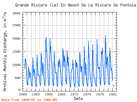
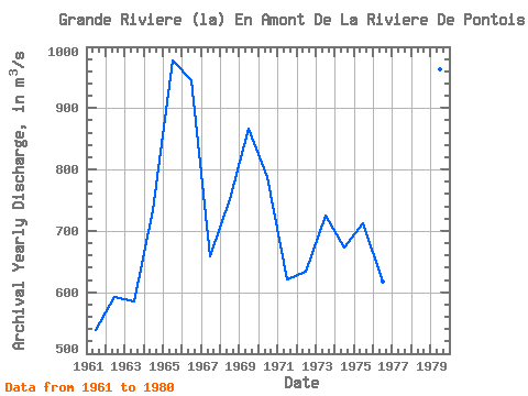
| Year | Jan | Feb | Mar | Apr | May | Jun | Jul | Aug | Sep | Oct | Nov | Dec | Annual | 1960 | 859.00 | 1190.00 | 1230.00 | 1170.00 | 1020.00 | 690.00 | 1961 | 435.00 | 314.00 | 232.00 | 217.00 | 608.00 | 919.00 | 760.00 | 525.00 | 518.00 | 724.00 | 652.00 | 549.00 | 537.75 | 1962 | 377.00 | 252.00 | 195.00 | 188.00 | 700.00 | 1270.00 | 859.00 | 579.00 | 796.00 | 842.00 | 613.00 | 439.00 | 592.50 | 1963 | 303.00 | 214.00 | 180.00 | 188.00 | 864.00 | 1390.00 | 848.00 | 675.00 | 588.00 | 626.00 | 575.00 | 560.00 | 584.25 | 1964 | 353.00 | 262.00 | 219.00 | 259.00 | 1380.00 | 1460.00 | 880.00 | 595.00 | 773.00 | 1080.00 | 906.00 | 636.00 | 733.58 | 1965 | 433.00 | 331.00 | 252.00 | 192.00 | 612.00 | 1900.00 | 2040.00 | 1510.00 | 1550.00 | 1320.00 | 936.00 | 662.00 | 978.17 | 1966 | 385.00 | 262.00 | 213.00 | 269.00 | 777.00 | 2000.00 | 1540.00 | 1700.00 | 1260.00 | 1180.00 | 1030.00 | 731.00 | 945.58 | 1967 | 414.00 | 295.00 | 229.00 | 192.00 | 692.00 | 1500.00 | 957.00 | 958.00 | 727.00 | 684.00 | 718.00 | 530.00 | 658.00 | 1968 | 299.00 | 224.00 | 182.00 | 267.00 | 1150.00 | 1080.00 | 909.00 | 1220.00 | 1130.00 | 1080.00 | 899.00 | 586.00 | 752.17 | 1969 | 428.00 | 309.00 | 231.00 | 186.00 | 610.00 | 1620.00 | 1470.00 | 1030.00 | 905.00 | 1350.00 | 1200.00 | 1060.00 | 866.58 | 1970 | 705.00 | 453.00 | 331.00 | 257.00 | 671.00 | 1540.00 | 1230.00 | 960.00 | 1280.00 | 898.00 | 635.00 | 500.00 | 788.33 | 1971 | 305.00 | 204.00 | 155.00 | 189.00 | 641.00 | 750.00 | 847.00 | 847.00 | 857.00 | 1180.00 | 945.00 | 533.00 | 621.08 | 1972 | 321.00 | 241.00 | 187.00 | 141.00 | 423.00 | 1180.00 | 1040.00 | 897.00 | 1080.00 | 999.00 | 699.00 | 395.00 | 633.58 | 1973 | 263.00 | 219.00 | 189.00 | 186.00 | 1450.00 | 1470.00 | 1050.00 | 759.00 | 723.00 | 943.00 | 915.00 | 540.00 | 725.58 | 1974 | 317.00 | 254.00 | 229.00 | 184.00 | 616.00 | 1700.00 | 1100.00 | 592.00 | 635.00 | 1070.00 | 838.00 | 534.00 | 672.42 | 1975 | 337.00 | 256.00 | 203.00 | 182.00 | 730.00 | 1890.00 | 1270.00 | 1220.00 | 858.00 | 601.00 | 590.00 | 408.00 | 712.08 | 1976 | 269.00 | 203.00 | 173.00 | 187.00 | 1400.00 | 1770.00 | 868.00 | 683.00 | 555.00 | 510.00 | 432.00 | 360.00 | 617.50 | 1977 | 292.00 | 244.00 | 206.00 | 181.00 | 841.00 | 1950.00 | 1200.00 | 966.00 | 961.00 | 839.00 | 907.00 | 907.00 | 791.17 | 1978 | 566.00 | 376.00 | 273.00 | 221.00 | 834.00 | 1480.00 | 1400.00 | 1640.00 | 1530.00 | 1040.00 | 823.00 | 715.00 | 908.17 | 1979 | 455.00 | 304.00 | 246.00 | 282.00 | 1870.00 | 2100.00 | 1150.00 | 879.00 | 969.00 | 1230.00 | 1310.00 | 771.00 | 963.83 | 1980 | 422.00 | 290.00 | 241.00 | 239.00 | 1250.00 | 1630.00 | 1210.00 | 1000.00 | 776.00 | 882.00 | 775.00 | 567.00 | 773.50 | 1981 | 420.00 | 334.00 | 276.00 | 208.00 | 736.00 |
|---|
| Other Close Sites | ||||||
|---|---|---|---|---|---|---|
| PointID | Latitude | Longitude | Drainage Area | Source | Name | |
| 5123 | "DE PONTOIS (RIVIERE) PRES DE LA GRANDE RIVIERE" | 53.62 | -1049635 | Hydat | ||
 Return to R-Arctic Net Home Page