|
|
|||||||||||||||||
| Point ID: 5100 | Downloads | Plots | Site Data | Code: 03BF001 |
|
|
|||||||||||||||||
| Download | |
|---|---|
| Site Descriptor Information | Site Time Series Data |
| Link to all available data | |
|
|
| View: | Statistics | Time Series |
| Units: | mm |
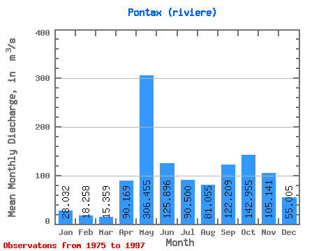
| Statistic | Jan | Feb | Mar | Apr | May | Jun | Jul | Aug | Sep | Oct | Nov | Dec | Annual |
|---|---|---|---|---|---|---|---|---|---|---|---|---|---|
| Mean | 28.03 | 18.26 | 15.36 | 90.17 | 306.45 | 125.90 | 90.50 | 81.06 | 122.21 | 142.96 | 105.14 | 55.01 | 99.01 |
| Standard Deviation | 11.38 | 5.26 | 5.81 | 66.42 | 91.43 | 39.49 | 35.74 | 42.75 | 50.62 | 35.88 | 30.71 | 22.83 | 12.18 |
| Min | 14.50 | 9.17 | 7.36 | 7.92 | 117.00 | 38.60 | 55.80 | 19.30 | 42.20 | 82.10 | 49.00 | 27.30 | 80.92 |
| Max | 70.40 | 33.80 | 34.10 | 279.00 | 500.00 | 203.00 | 189.00 | 160.00 | 214.00 | 215.00 | 162.00 | 122.00 | 121.19 |
| Coefficient of Variation | 0.41 | 0.29 | 0.38 | 0.74 | 0.30 | 0.31 | 0.40 | 0.53 | 0.41 | 0.25 | 0.29 | 0.41 | 0.12 |
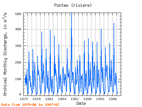
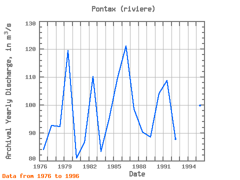
| Year | Jan | Feb | Mar | Apr | May | Jun | Jul | Aug | Sep | Oct | Nov | Dec | Annual | 1975 | 104.00 | 63.80 | 131.00 | 63.20 | 83.90 | 159.00 | 45.70 | 1976 | 19.90 | 12.60 | 11.40 | 155.00 | 265.00 | 125.00 | 89.60 | 120.00 | 52.00 | 82.10 | 49.00 | 27.30 | 84.08 | 1977 | 18.60 | 15.60 | 16.60 | 279.00 | 140.00 | 38.60 | 64.10 | 98.90 | 200.00 | 114.00 | 89.50 | 36.80 | 92.64 | 1978 | 14.50 | 9.17 | 7.36 | 11.50 | 237.00 | 127.00 | 128.00 | 154.00 | 125.00 | 119.00 | 116.00 | 58.30 | 92.24 | 1979 | 26.80 | 17.10 | 14.10 | 96.90 | 385.00 | 176.00 | 77.50 | 76.00 | 192.00 | 172.00 | 122.00 | 78.10 | 119.46 | 1980 | 31.90 | 19.50 | 14.90 | 56.70 | 280.00 | 140.00 | 95.10 | 46.00 | 42.20 | 146.00 | 70.00 | 28.80 | 80.92 | 1981 | 18.40 | 16.90 | 34.10 | 74.90 | 394.00 | 115.00 | 65.10 | 19.30 | 76.30 | 116.00 | 76.30 | 31.90 | 86.52 | 1982 | 17.20 | 11.60 | 9.63 | 29.80 | 361.00 | 118.00 | 189.00 | 129.00 | 153.00 | 119.00 | 112.00 | 72.20 | 110.12 | 1983 | 27.90 | 17.80 | 14.70 | 49.70 | 307.00 | 134.00 | 68.50 | 41.00 | 105.00 | 127.00 | 69.80 | 36.80 | 83.27 | 1984 | 24.30 | 21.90 | 19.20 | 146.00 | 175.00 | 154.00 | 117.00 | 59.10 | 78.50 | 132.00 | 98.70 | 122.00 | 95.64 | 1985 | 70.40 | 33.80 | 22.30 | 90.30 | 283.00 | 158.00 | 111.00 | 127.00 | 108.00 | 160.00 | 104.00 | 48.30 | 109.67 | 1986 | 29.60 | 23.20 | 20.50 | 121.00 | 500.00 | 203.00 | 77.30 | 113.00 | 141.00 | 132.00 | 59.60 | 34.10 | 121.19 | 1987 | 21.00 | 14.30 | 11.10 | 172.00 | 117.00 | 64.70 | 68.00 | 97.80 | 214.00 | 153.00 | 162.00 | 88.10 | 98.58 | 1988 | 36.70 | 21.80 | 16.10 | 171.00 | 242.00 | 95.00 | 67.30 | 22.40 | 116.00 | 101.00 | 127.00 | 67.70 | 90.33 | 1989 | 28.30 | 14.70 | 9.11 | 7.92 | 328.00 | 194.00 | 65.20 | 31.20 | 73.80 | 150.00 | 113.00 | 47.20 | 88.54 | 1990 | 25.90 | 17.70 | 13.40 | 66.90 | 343.00 | 162.00 | 55.80 | 66.80 | 121.00 | 197.00 | 109.00 | 70.40 | 104.08 | 1991 | 35.30 | 21.50 | 15.20 | 148.00 | 324.00 | 119.00 | 64.50 | 45.10 | 149.00 | 202.00 | 133.00 | 48.50 | 108.76 | 1992 | 26.30 | 16.60 | 11.20 | 34.00 | 321.00 | 85.00 | 56.20 | 50.10 | 156.00 | 144.00 | 99.80 | 53.10 | 87.78 | 1993 | 30.30 | 19.20 | 13.00 | 75.90 | 401.00 | 148.00 | 157.00 | 83.00 | 171.00 | 163.00 | 65.40 | 31.40 | 113.18 | 1994 | 18.00 | 12.40 | 10.10 | 34.40 | 289.00 | 110.00 | 134.00 | 160.00 | 183.00 | 182.00 | 118.00 | 69.60 | 110.04 | 1995 | 34.00 | 23.60 | 20.40 | 28.80 | 314.00 | 105.00 | 124.00 | 52.90 | 102.00 | 215.00 | 125.00 | 53.90 | 99.88 | 1996 | 30.10 | 21.80 | 19.10 | 48.70 | 436.00 | 137.00 | 78.50 | 59.60 | 66.60 | 135.00 | 135.00 | 59.90 | 102.28 | 1997 | 31.30 | 18.90 | 14.40 | 85.30 | 300.00 | 83.30 | 65.00 |
|---|
 Return to R-Arctic Net Home Page