|
|
|||||||||||||||||
| Point ID: 5093 | Downloads | Plots | Site Data | Code: 03BB002 |
|
|
|||||||||||||||||
| Download | |
|---|---|
| Site Descriptor Information | Site Time Series Data |
| Link to all available data | |
|
|
| View: | Statistics | Time Series |
| Units: | mm |
| Statistic | Jan | Feb | Mar | Apr | May | Jun | Jul | Aug | Sep | Oct | Nov | Dec | Annual |
|---|---|---|---|---|---|---|---|---|---|---|---|---|---|
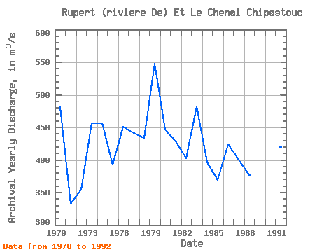
| Mean | 324.38 | 272.19 | 235.30 | 219.22 | 370.35 | 599.73 | 607.96 | 548.44 | 518.46 | 519.88 | 491.12 | 410.46 | 421.59 |
| Standard Deviation | 54.55 | 48.34 | 41.01 | 36.10 | 74.30 | 116.29 | 117.19 | 101.22 | 92.84 | 83.35 | 74.89 | 62.94 | 49.98 |
| Min | 263.00 | 199.00 | 162.00 | 143.00 | 251.00 | 376.00 | 347.00 | 344.00 | 308.00 | 332.00 | 383.00 | 335.00 | 332.33 |
| Max | 462.00 | 376.00 | 313.00 | 273.00 | 532.00 | 816.00 | 808.00 | 735.00 | 690.00 | 708.00 | 668.00 | 576.00 | 547.58 |
| Coefficient of Variation | 0.17 | 0.18 | 0.17 | 0.17 | 0.20 | 0.19 | 0.19 | 0.18 | 0.18 | 0.16 | 0.15 | 0.15 | 0.12 |
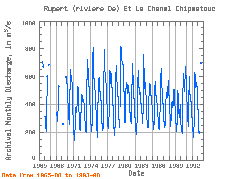
| Year | Jan | Feb | Mar | Apr | May | Jun | Jul | Aug | Sep | Oct | Nov | Dec | Annual | 1965 | 709.00 | 671.00 | 1966 | 309.00 | 243.00 | 206.00 | 312.00 | 604.00 | 688.00 | 1968 | 335.00 | 293.00 | 273.00 | 430.00 | 533.00 | 1969 | 261.00 | 258.00 | 598.00 | 602.00 | 586.00 | 513.00 | 1970 | 441.00 | 376.00 | 313.00 | 255.00 | 379.00 | 633.00 | 649.00 | 624.00 | 600.00 | 583.00 | 544.00 | 377.00 | 481.17 | 1971 | 263.00 | 199.00 | 162.00 | 143.00 | 285.00 | 376.00 | 347.00 | 344.00 | 433.00 | 530.00 | 516.00 | 390.00 | 332.33 | 1972 | 299.00 | 254.00 | 226.00 | 208.00 | 251.00 | 428.00 | 470.00 | 454.00 | 416.00 | 431.00 | 412.00 | 404.00 | 354.42 | 1973 | 308.00 | 248.00 | 207.00 | 195.00 | 440.00 | 720.00 | 726.00 | 595.00 | 531.00 | 542.00 | 521.00 | 438.00 | 455.92 | 1974 | 346.00 | 281.00 | 229.00 | 203.00 | 286.00 | 749.00 | 808.00 | 640.00 | 531.00 | 515.00 | 485.00 | 406.00 | 456.58 | 1975 | 306.00 | 232.00 | 181.00 | 161.00 | 287.00 | 535.00 | 587.00 | 598.00 | 511.00 | 470.00 | 460.00 | 389.00 | 393.08 | 1976 | 288.00 | 234.00 | 208.00 | 230.00 | 480.00 | 795.00 | 685.00 | 584.00 | 557.00 | 552.00 | 459.00 | 344.00 | 451.33 | 1977 | 277.00 | 242.00 | 226.00 | 236.00 | 381.00 | 648.00 | 633.00 | 555.00 | 624.00 | 559.00 | 486.00 | 434.00 | 441.75 | 1978 | 346.00 | 247.00 | 195.00 | 175.00 | 287.00 | 581.00 | 684.00 | 656.00 | 577.00 | 549.00 | 497.00 | 409.00 | 433.58 | 1979 | 312.00 | 263.00 | 232.00 | 232.00 | 532.00 | 816.00 | 807.00 | 735.00 | 690.00 | 708.00 | 668.00 | 576.00 | 547.58 | 1980 | 408.00 | 310.00 | 270.00 | 272.00 | 469.00 | 561.00 | 552.00 | 534.00 | 479.00 | 535.00 | 532.00 | 435.00 | 446.42 | 1981 | 360.00 | 316.00 | 288.00 | 264.00 | 389.00 | 697.00 | 690.00 | 534.00 | 449.00 | 432.00 | 383.00 | 335.00 | 428.08 | 1982 | 270.00 | 220.00 | 188.00 | 185.00 | 342.00 | 548.00 | 648.00 | 564.00 | 482.00 | 467.00 | 482.00 | 430.00 | 402.17 | 1983 | 379.00 | 358.00 | 310.00 | 263.00 | 396.00 | 757.00 | 725.00 | 596.00 | 512.00 | 557.00 | 521.00 | 408.00 | 481.83 | 1984 | 312.00 | 258.00 | 232.00 | 233.00 | 382.00 | 533.00 | 554.00 | 543.00 | 461.00 | 459.00 | 427.00 | 360.00 | 396.17 | 1985 | 295.00 | 258.00 | 231.00 | 216.00 | 282.00 | 515.00 | 564.00 | 506.00 | 419.00 | 413.00 | 399.00 | 339.00 | 369.75 | 1986 | 275.00 | 233.00 | 216.00 | 228.00 | 462.00 | 593.00 | 660.00 | 577.00 | 542.00 | 498.00 | 447.00 | 363.00 | 424.50 | 1987 | 294.00 | 253.00 | 232.00 | 251.00 | 390.00 | 486.00 | 472.00 | 445.00 | 497.00 | 571.00 | 492.00 | 428.00 | 400.92 | 1988 | 352.00 | 304.00 | 264.00 | 239.00 | 322.00 | 411.00 | 418.00 | 373.00 | 403.00 | 505.00 | 503.00 | 423.00 | 376.42 | 1989 | 345.00 | 285.00 | 236.00 | 205.00 | 300.00 | 498.00 | 455.00 | 356.00 | 308.00 | 332.00 | 400.00 | 349.00 | 339.08 | 1990 | 270.00 | 229.00 | 206.00 | 191.00 | 415.00 | 625.00 | 598.00 | 518.00 | 492.00 | 675.00 | 667.00 | 550.00 | 453.00 | 1991 | 462.00 | 367.00 | 307.00 | 243.00 | 391.00 | 604.00 | 562.00 | 486.00 | 449.00 | 432.00 | 403.00 | 339.00 | 420.42 | 1992 | 267.00 | 218.00 | 189.00 | 159.00 | 309.00 | 629.00 | 601.00 | 521.00 | 560.00 | 560.00 | 497.00 | 412.00 | 410.17 | 1993 | 310.00 | 248.00 | 208.00 | 195.00 | 430.00 | 718.00 | 696.00 | 664.00 |
|---|
 Return to R-Arctic Net Home Page
