|
|
|||||||||||||||||
| Point ID: 5091 | Downloads | Plots | Site Data | Code: 03BA003 |
|
|
|||||||||||||||||
| Download | |
|---|---|
| Site Descriptor Information | Site Time Series Data |
| Link to all available data | |

|
|
| View: | Statistics | Time Series |
| Units: | mm |
| Statistic | Jan | Feb | Mar | Apr | May | Jun | Jul | Aug | Sep | Oct | Nov | Dec | Annual |
|---|---|---|---|---|---|---|---|---|---|---|---|---|---|
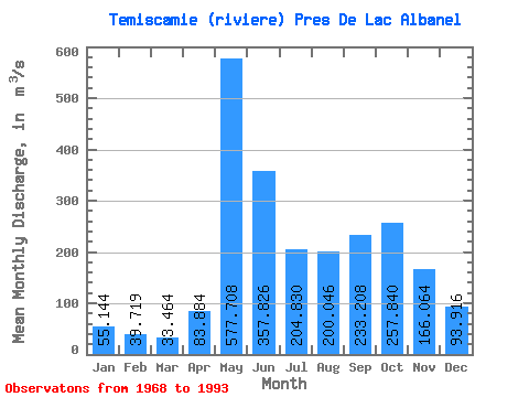
| Mean | 55.14 | 39.72 | 33.46 | 83.88 | 577.71 | 357.83 | 204.83 | 200.05 | 233.21 | 257.84 | 166.06 | 93.92 | 194.31 |
| Standard Deviation | 11.44 | 6.74 | 8.69 | 78.29 | 161.75 | 151.38 | 69.71 | 63.18 | 59.75 | 66.94 | 38.59 | 26.92 | 27.71 |
| Min | 39.50 | 30.10 | 21.40 | 27.90 | 288.00 | 145.00 | 91.10 | 70.10 | 112.00 | 175.00 | 96.60 | 59.90 | 140.00 |
| Max | 82.00 | 56.20 | 68.00 | 394.00 | 874.00 | 803.00 | 422.00 | 345.00 | 336.00 | 429.00 | 243.00 | 165.00 | 260.93 |
| Coefficient of Variation | 0.21 | 0.17 | 0.26 | 0.93 | 0.28 | 0.42 | 0.34 | 0.32 | 0.26 | 0.26 | 0.23 | 0.29 | 0.14 |
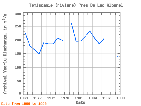
| Year | Jan | Feb | Mar | Apr | May | Jun | Jul | Aug | Sep | Oct | Nov | Dec | Annual | 1968 | 40.50 | 30.60 | 161.00 | 435.00 | 154.00 | 184.00 | 296.00 | 222.00 | 262.00 | 157.00 | 80.00 | 1969 | 54.60 | 41.50 | 30.20 | 32.90 | 377.00 | 534.00 | 422.00 | 256.00 | 308.00 | 292.00 | 222.00 | 136.00 | 225.52 | 1970 | 82.00 | 54.10 | 38.70 | 34.70 | 498.00 | 453.00 | 149.00 | 242.00 | 245.00 | 181.00 | 96.60 | 64.80 | 178.24 | 1971 | 49.80 | 39.10 | 30.60 | 62.10 | 436.00 | 145.00 | 140.00 | 247.00 | 231.00 | 360.00 | 152.00 | 80.10 | 164.39 | 1972 | 53.20 | 41.70 | 35.40 | 33.70 | 376.00 | 299.00 | 183.00 | 188.00 | 197.00 | 201.00 | 113.00 | 59.90 | 148.41 | 1973 | 41.70 | 35.20 | 31.30 | 34.20 | 621.00 | 371.00 | 252.00 | 177.00 | 213.00 | 251.00 | 156.00 | 90.10 | 189.46 | 1974 | 59.00 | 42.00 | 32.00 | 27.90 | 288.00 | 803.00 | 172.00 | 144.00 | 207.00 | 237.00 | 153.00 | 66.10 | 185.92 | 1975 | 39.50 | 31.50 | 30.30 | 34.80 | 558.00 | 358.00 | 248.00 | 211.00 | 177.00 | 189.00 | 237.00 | 115.00 | 185.76 | 1976 | 59.80 | 40.10 | 37.40 | 150.00 | 874.00 | 307.00 | 146.00 | 182.00 | 209.00 | 231.00 | 162.00 | 84.60 | 206.91 | 1977 | 54.00 | 41.70 | 37.10 | 46.20 | 695.00 | 417.00 | 148.00 | 213.00 | 262.00 | 175.00 | 196.00 | 97.80 | 198.57 | 1978 | 54.40 | 39.10 | 32.40 | 30.10 | 512.00 | 228.00 | 169.00 | 134.00 | 1979 | 55.50 | 33.00 | 27.70 | 165.00 | 801.00 | 454.00 | 228.00 | 283.00 | 336.00 | 383.00 | 236.00 | 129.00 | 260.93 | 1980 | 52.30 | 32.60 | 26.40 | 82.90 | 612.00 | 239.00 | 206.00 | 283.00 | 193.00 | 335.00 | 179.00 | 94.60 | 194.65 | 1981 | 59.50 | 56.20 | 68.00 | 79.10 | 628.00 | 505.00 | 203.00 | 145.00 | 175.00 | 202.00 | 152.00 | 88.00 | 196.73 | 1982 | 50.30 | 33.60 | 26.60 | 38.40 | 680.00 | 404.00 | 300.00 | 144.00 | 222.00 | 252.00 | 243.00 | 165.00 | 213.24 | 1983 | 82.00 | 46.70 | 37.40 | 83.80 | 747.00 | 501.00 | 211.00 | 216.00 | 312.00 | 310.00 | 153.00 | 89.20 | 232.43 | 1984 | 56.20 | 47.40 | 44.20 | 128.00 | 585.00 | 311.00 | 293.00 | 201.00 | 231.00 | 243.00 | 196.00 | 135.00 | 205.90 | 1985 | 80.20 | 47.30 | 33.20 | 37.10 | 428.00 | 482.00 | 200.00 | 190.00 | 167.00 | 283.00 | 188.00 | 89.50 | 185.44 | 1986 | 51.30 | 36.60 | 31.10 | 121.00 | 730.00 | 302.00 | 234.00 | 181.00 | 307.00 | 233.00 | 133.00 | 73.90 | 202.82 | 1987 | 45.30 | 31.30 | 29.00 | 394.00 | 349.00 | 242.00 | 231.00 | 345.00 | 282.00 | 185.00 | 127.00 | 78.30 | 194.91 | 1988 | 42.00 | 32.70 | 29.50 | 108.00 | 509.00 | 177.00 | 176.00 | 121.00 | 169.00 | 323.00 | 159.00 | 91.60 | 161.48 | 1989 | 55.00 | 40.70 | 29.00 | 29.60 | 570.00 | 206.00 | 91.10 | 70.10 | 112.00 | 247.00 | 166.00 | 63.50 | 140.00 | 1990 | 42.40 | 35.90 | 38.30 | 69.60 | 722.00 | 300.00 | 158.00 | 154.00 | 323.00 | 429.00 | 144.00 | 89.60 | 208.82 | 1991 | 59.00 | 43.50 | 266.00 | 136.00 | 144.00 | 186.00 | 209.00 | 139.00 | 72.80 | 1992 | 51.10 | 38.60 | 28.80 | 35.70 | 168.00 | 311.00 | 205.00 | 123.00 | 79.50 | 1993 | 48.50 | 30.10 | 21.40 | 77.30 | 834.00 |
|---|
 Return to R-Arctic Net Home Page