|
|
|||||||||||||||||
| Point ID: 5083 | Downloads | Plots | Site Data | Code: 03AC002 |
|
|
|||||||||||||||||
| Download | |
|---|---|
| Site Descriptor Information | Site Time Series Data |
| Link to all available data | |
|

|
| View: | Statistics | Time Series |
| Units: | mm |
| Statistic | Jan | Feb | Mar | Apr | May | Jun | Jul | Aug | Sep | Oct | Nov | Dec | Annual |
|---|---|---|---|---|---|---|---|---|---|---|---|---|---|
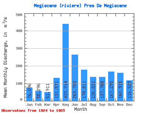
| Mean | 76.10 | 58.30 | 51.91 | 131.57 | 439.91 | 263.70 | 178.81 | 136.83 | 137.79 | 167.29 | 160.91 | 116.53 | 167.06 |
| Standard Deviation | 17.03 | 12.90 | 11.46 | 56.66 | 138.31 | 103.29 | 74.51 | 63.04 | 64.43 | 85.53 | 59.88 | 27.37 | 32.09 |
| Min | 38.80 | 32.80 | 31.80 | 45.50 | 216.00 | 116.00 | 73.80 | 43.90 | 50.20 | 62.80 | 58.50 | 52.90 | 111.98 |
| Max | 117.00 | 82.90 | 81.80 | 298.00 | 801.00 | 476.00 | 366.00 | 266.00 | 311.00 | 542.00 | 290.00 | 173.00 | 248.88 |
| Coefficient of Variation | 0.22 | 0.22 | 0.22 | 0.43 | 0.31 | 0.39 | 0.42 | 0.46 | 0.47 | 0.51 | 0.37 | 0.23 | 0.19 |
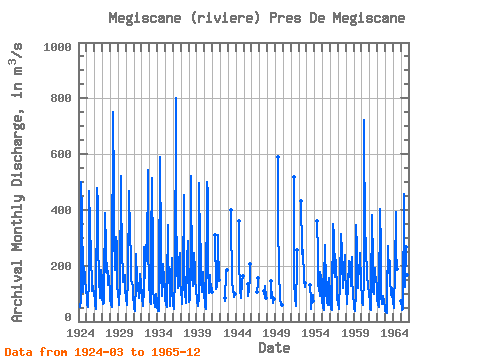
| Year | Jan | Feb | Mar | Apr | May | Jun | Jul | Aug | Sep | Oct | Nov | Dec | Annual | 1924 | 50.70 | 77.30 | 499.00 | 389.00 | 147.00 | 104.00 | 197.00 | 159.00 | 135.00 | 126.00 | 1925 | 72.10 | 59.30 | 52.90 | 162.00 | 467.00 | 346.00 | 236.00 | 253.00 | 108.00 | 129.00 | 117.00 | 105.00 | 175.61 | 1926 | 72.90 | 55.00 | 46.80 | 45.50 | 479.00 | 423.00 | 277.00 | 156.00 | 85.40 | 85.20 | 186.00 | 149.00 | 171.73 | 1927 | 88.80 | 61.90 | 65.20 | 136.00 | 390.00 | 266.00 | 179.00 | 208.00 | 131.00 | 181.00 | 150.00 | 108.00 | 163.74 | 1928 | 79.20 | 60.20 | 53.10 | 155.00 | 750.00 | 476.00 | 316.00 | 183.00 | 204.00 | 302.00 | 276.00 | 132.00 | 248.88 | 1929 | 93.40 | 71.90 | 58.90 | 130.00 | 522.00 | 429.00 | 275.00 | 143.00 | 163.00 | 155.00 | 167.00 | 117.00 | 193.77 | 1930 | 79.80 | 61.50 | 59.40 | 159.00 | 466.00 | 409.00 | 366.00 | 175.00 | 150.00 | 138.00 | 124.00 | 93.30 | 190.08 | 1931 | 57.30 | 45.20 | 39.00 | 142.00 | 243.00 | 154.00 | 126.00 | 128.00 | 84.50 | 115.00 | 171.00 | 136.00 | 120.08 | 1932 | 96.10 | 82.90 | 56.80 | 117.00 | 266.00 | 157.00 | 275.00 | 229.00 | 239.00 | 542.00 | 280.00 | 128.00 | 205.73 | 1933 | 90.50 | 74.90 | 63.40 | 269.00 | 514.00 | 232.00 | 120.00 | 74.50 | 50.20 | 62.80 | 98.70 | 70.40 | 143.37 | 1934 | 50.30 | 39.00 | 39.10 | 138.00 | 591.00 | 265.00 | 181.00 | 92.50 | 153.00 | 206.00 | 149.00 | 123.00 | 168.91 | 1935 | 80.30 | 60.80 | 53.20 | 134.00 | 345.00 | 207.00 | 183.00 | 88.70 | 54.90 | 149.00 | 228.00 | 113.00 | 141.41 | 1936 | 61.30 | 45.40 | 66.90 | 137.00 | 801.00 | 446.00 | 163.00 | 155.00 | 121.00 | 222.00 | 246.00 | 142.00 | 217.22 | 1937 | 104.00 | 76.00 | 64.00 | 157.00 | 453.00 | 206.00 | 107.00 | 68.10 | 104.00 | 216.00 | 290.00 | 173.00 | 168.18 | 1938 | 93.30 | 68.50 | 81.80 | 298.00 | 523.00 | 162.00 | 126.00 | 241.00 | 245.00 | 185.00 | 161.00 | 107.00 | 190.97 | 1939 | 86.90 | 72.60 | 56.80 | 86.70 | 495.00 | 279.00 | 279.00 | 152.00 | 106.00 | 161.00 | 176.00 | 99.20 | 170.85 | 1940 | 67.70 | 53.10 | 43.60 | 62.20 | 500.00 | 456.00 | 205.00 | 102.00 | 167.00 | 114.00 | 136.00 | 107.00 | 167.80 | 1941 | 309.00 | 116.00 | 148.00 | 124.00 | 311.00 | 283.00 | 147.00 | 1942 | 83.90 | 75.10 | 180.00 | 184.00 | 1943 | 399.00 | 359.00 | 150.00 | 106.00 | 122.00 | 87.80 | 98.20 | 1944 | 360.00 | 236.00 | 103.00 | 93.60 | 82.90 | 143.00 | 163.00 | 1945 | 136.00 | 91.10 | 113.00 | 155.00 | 205.00 | 1946 | 104.00 | 139.00 | 157.00 | 1947 | 111.00 | 85.60 | 127.00 | 82.80 | 1948 | 144.00 | 85.10 | 106.00 | 72.60 | 65.00 | 79.90 | 1949 | 589.00 | 350.00 | 188.00 | 75.30 | 76.00 | 66.30 | 58.50 | 1951 | 517.00 | 138.00 | 89.10 | 56.30 | 61.70 | 200.00 | 257.00 | 1952 | 432.00 | 258.00 | 222.00 | 256.00 | 148.00 | 122.00 | 137.00 | 1953 | 132.00 | 73.80 | 43.90 | 85.50 | 94.10 | 73.70 | 1954 | 360.00 | 240.00 | 126.00 | 122.00 | 92.40 | 179.00 | 160.00 | 148.00 | 1955 | 78.60 | 52.10 | 40.90 | 148.00 | 273.00 | 135.00 | 105.00 | 70.40 | 58.80 | 126.00 | 155.00 | 101.00 | 111.98 | 1956 | 66.10 | 44.30 | 39.60 | 81.30 | 349.00 | 310.00 | 184.00 | 161.00 | 241.00 | 199.00 | 119.00 | 86.00 | 156.69 | 1957 | 64.50 | 52.50 | 46.20 | 144.00 | 312.00 | 170.00 | 283.00 | 119.00 | 180.00 | 188.00 | 239.00 | 173.00 | 164.27 | 1958 | 117.00 | 78.10 | 64.40 | 128.00 | 216.00 | 198.00 | 189.00 | 127.00 | 197.00 | 231.00 | 156.00 | 95.00 | 149.71 | 1959 | 58.50 | 44.30 | 37.90 | 101.00 | 345.00 | 259.00 | 119.00 | 135.00 | 199.00 | 210.00 | 247.00 | 140.00 | 157.97 | 1960 | 76.20 | 68.00 | 60.00 | 159.00 | 724.00 | 272.00 | 299.00 | 258.00 | 173.00 | 116.00 | 120.00 | 107.00 | 202.68 | 1961 | 63.70 | 45.80 | 41.60 | 101.00 | 383.00 | 209.00 | 110.00 | 98.30 | 190.00 | 171.00 | 148.00 | 128.00 | 140.78 | 1962 | 79.30 | 62.90 | 50.70 | 86.60 | 405.00 | 259.00 | 90.80 | 61.80 | 77.90 | 92.10 | 69.80 | 52.90 | 115.73 | 1963 | 38.80 | 32.80 | 31.80 | 94.40 | 270.00 | 173.00 | 222.00 | 218.00 | 151.00 | 93.50 | 121.00 | 101.00 | 128.94 | 1964 | 65.60 | 55.00 | 49.00 | 189.00 | 392.00 | 258.00 | 188.00 | 1965 | 72.40 | 50.00 | 39.80 | 46.00 | 458.00 | 239.00 | 123.00 | 266.00 | 251.00 | 302.00 | 168.00 | 102.00 | 176.43 |
|---|
 Return to R-Arctic Net Home Page