|
|
|||||||||||||||||
| Point ID: 464 | Downloads | Plots | Site Data | Code: 05DC007 |
|
|
|||||||||||||||||
| Download | |
|---|---|
| Site Descriptor Information | Site Time Series Data |
| Link to all available data | |
|
|
| View: | Statistics | Time Series |
| Units: | mm |
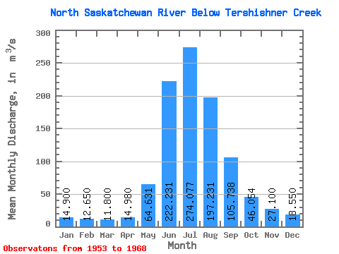
| Statistic | Jan | Feb | Mar | Apr | May | Jun | Jul | Aug | Sep | Oct | Nov | Dec | Annual |
|---|---|---|---|---|---|---|---|---|---|---|---|---|---|
| Mean | 14.90 | 12.65 | 11.80 | 14.98 | 64.63 | 222.23 | 274.08 | 197.23 | 105.74 | 46.05 | 27.10 | 18.55 | 86.42 |
| Standard Deviation | 3.96 | 1.48 | 0.99 | 2.65 | 25.40 | 45.90 | 28.67 | 36.60 | 27.43 | 9.69 | 4.60 | ||
| Min | 12.10 | 11.60 | 11.10 | 11.70 | 34.50 | 146.00 | 230.00 | 143.00 | 74.80 | 30.90 | 27.10 | 15.30 | 86.42 |
| Max | 17.70 | 13.70 | 12.50 | 17.80 | 107.00 | 307.00 | 336.00 | 270.00 | 159.00 | 59.50 | 27.10 | 21.80 | 86.42 |
| Coefficient of Variation | 0.27 | 0.12 | 0.08 | 0.18 | 0.39 | 0.21 | 0.10 | 0.19 | 0.26 | 0.21 | 0.25 |
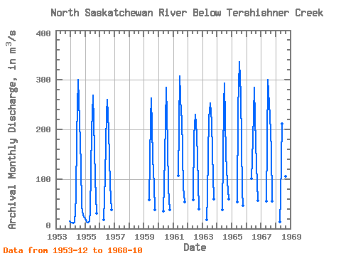
| Year | Jan | Feb | Mar | Apr | May | Jun | Jul | Aug | Sep | Oct | Nov | Dec | Annual | 1953 | 15.30 | 1954 | 12.10 | 11.60 | 11.10 | 11.70 | 63.00 | 189.00 | 300.00 | 217.00 | 128.00 | 44.70 | 27.10 | 21.80 | 86.42 | 1955 | 17.70 | 13.70 | 12.50 | 15.10 | 34.50 | 199.00 | 269.00 | 160.00 | 99.70 | 30.90 | 1956 | 17.80 | 107.00 | 233.00 | 260.00 | 197.00 | 88.10 | 37.50 | 1959 | 57.50 | 220.00 | 263.00 | 143.00 | 88.30 | 38.10 | 1960 | 34.80 | 146.00 | 285.00 | 172.00 | 80.60 | 38.00 | 1961 | 107.00 | 307.00 | 230.00 | 225.00 | 82.90 | 53.40 | 1962 | 57.70 | 187.00 | 230.00 | 192.00 | 92.80 | 39.60 | 1963 | 17.30 | 68.50 | 223.00 | 253.00 | 216.00 | 152.00 | 59.50 | 1964 | 38.20 | 251.00 | 293.00 | 149.00 | 94.40 | 58.80 | 1965 | 54.20 | 241.00 | 336.00 | 270.00 | 74.80 | 47.10 | 1966 | 101.00 | 180.00 | 285.00 | 221.00 | 128.00 | 56.30 | 1967 | 54.60 | 301.00 | 276.00 | 227.00 | 159.00 | 55.90 | 1968 | 13.00 | 62.20 | 212.00 | 283.00 | 175.00 | 106.00 | 38.90 |
|---|
 Return to R-Arctic Net Home Page