|
|
|||||||||||||||||
| Point ID: 4360 | Downloads | Plots | Site Data | Code: 04LA001 |
|
|
|||||||||||||||||
| Download | |
|---|---|
| Site Descriptor Information | Site Time Series Data |
| Link to all available data | |

|
|
| View: | Statistics | Time Series |
| Units: | mm |
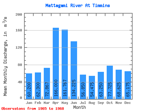
| Statistic | Jan | Feb | Mar | Apr | May | Jun | Jul | Aug | Sep | Oct | Nov | Dec | Annual |
|---|---|---|---|---|---|---|---|---|---|---|---|---|---|
| Mean | 60.20 | 62.30 | 72.87 | 166.00 | 161.77 | 134.22 | 56.85 | 54.48 | 63.25 | 77.72 | 68.62 | 65.17 | 87.59 |
| Standard Deviation | 22.70 | 18.83 | 4.85 | 51.97 | 82.25 | 55.61 | 21.45 | 18.86 | 31.05 | 40.42 | 17.10 | 27.10 | 14.38 |
| Min | 38.80 | 41.10 | 68.10 | 127.00 | 93.30 | 53.90 | 34.70 | 41.40 | 34.60 | 47.20 | 54.50 | 42.10 | 73.03 |
| Max | 84.00 | 77.10 | 77.80 | 225.00 | 253.00 | 182.00 | 80.10 | 81.90 | 107.00 | 133.00 | 89.20 | 103.00 | 101.78 |
| Coefficient of Variation | 0.38 | 0.30 | 0.07 | 0.31 | 0.51 | 0.41 | 0.38 | 0.35 | 0.49 | 0.52 | 0.25 | 0.42 | 0.16 |
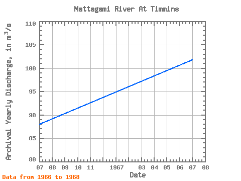
| Year | Jan | Feb | Mar | Apr | May | Jun | Jul | Aug | Sep | Oct | Nov | Dec | Annual | 1965 | 53.90 | 34.70 | 42.80 | 107.00 | 133.00 | 76.20 | 49.70 | 1966 | 57.80 | 68.70 | 68.10 | 146.00 | 139.00 | 182.00 | 43.10 | 41.40 | 34.60 | 82.80 | 89.20 | 103.00 | 87.97 | 1967 | 84.00 | 77.10 | 77.80 | 225.00 | 253.00 | 148.00 | 69.50 | 81.90 | 60.40 | 47.90 | 54.60 | 42.10 | 101.78 | 1968 | 38.80 | 41.10 | 72.70 | 127.00 | 93.30 | 153.00 | 80.10 | 51.80 | 51.00 | 47.20 | 54.50 | 65.90 | 73.03 |
|---|
 Return to R-Arctic Net Home Page