|
|
|||||||||||||||||
| Point ID: 4350 | Downloads | Plots | Site Data | Code: 04JC001 |
|
|
|||||||||||||||||
| Download | |
|---|---|
| Site Descriptor Information | Site Time Series Data |
| Link to all available data | |

|
|
| View: | Statistics | Time Series |
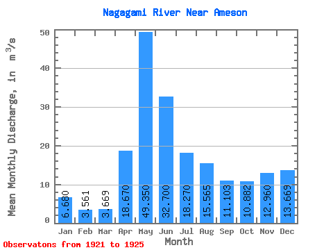
| Units: | mm |
| Statistic | Jan | Feb | Mar | Apr | May | Jun | Jul | Aug | Sep | Oct | Nov | Dec | Annual |
|---|---|---|---|---|---|---|---|---|---|---|---|---|---|
| Mean | 6.68 | 3.56 | 3.67 | 18.67 | 49.35 | 32.70 | 18.27 | 15.56 | 11.10 | 10.88 | 12.96 | 13.67 | 16.56 |
| Standard Deviation | 6.43 | 2.35 | 2.56 | 16.86 | 23.83 | 19.97 | 9.59 | 13.06 | 10.98 | 6.96 | 14.73 | 16.93 | 3.90 |
| Min | 1.30 | 0.93 | 0.71 | 4.01 | 21.20 | 20.10 | 6.28 | 3.43 | 2.21 | 1.42 | 1.80 | 0.84 | 13.80 |
| Max | 13.80 | 5.46 | 5.21 | 37.10 | 73.50 | 62.10 | 29.70 | 31.70 | 27.10 | 19.00 | 33.60 | 37.20 | 19.31 |
| Coefficient of Variation | 0.96 | 0.66 | 0.70 | 0.90 | 0.48 | 0.61 | 0.53 | 0.84 | 0.99 | 0.64 | 1.14 | 1.24 | 0.23 |
| Year | Jan | Feb | Mar | Apr | May | Jun | Jul | Aug | Sep | Oct | Nov | Dec | Annual | 1921 | 11.50 | 2.94 | 0.84 | 1922 | 73.50 | 20.30 | 6.28 | 3.43 | 2.21 | 1.42 | 1.80 | 1.84 | 1923 | 1.30 | 0.93 | 0.71 | 4.01 | 21.20 | 20.10 | 17.70 | 6.63 | 6.63 | 15.60 | 33.60 | 37.20 | 13.80 | 1924 | 13.80 | 5.46 | 5.09 | 14.90 | 38.70 | 28.30 | 19.40 | 31.70 | 27.10 | 19.00 | 13.50 | 14.80 | 19.31 | 1925 | 4.94 | 4.29 | 5.21 | 37.10 | 64.00 | 62.10 | 29.70 | 20.50 | 8.47 | 6.89 |
|---|
 Return to R-Arctic Net Home Page