|
|
|||||||||||||||||
| Point ID: 4347 | Downloads | Plots | Site Data | Code: 04HA001 |
|
|
|||||||||||||||||
| Download | |
|---|---|
| Site Descriptor Information | Site Time Series Data |
| Link to all available data | |
|
|
| View: | Statistics | Time Series |
| Units: | mm |
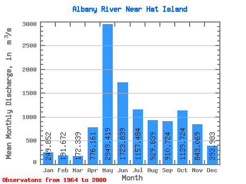
| Statistic | Jan | Feb | Mar | Apr | May | Jun | Jul | Aug | Sep | Oct | Nov | Dec | Annual |
|---|---|---|---|---|---|---|---|---|---|---|---|---|---|
| Mean | 249.85 | 191.67 | 172.34 | 776.16 | 2949.42 | 1723.84 | 1157.48 | 929.84 | 910.72 | 1139.72 | 843.07 | 393.98 | 958.56 |
| Standard Deviation | 97.29 | 73.90 | 63.95 | 496.23 | 782.34 | 692.21 | 536.15 | 597.05 | 637.89 | 578.11 | 391.84 | 175.91 | 275.55 |
| Min | 81.40 | 77.50 | 76.30 | 145.00 | 922.00 | 808.00 | 334.00 | 195.00 | 114.00 | 121.00 | 131.00 | 91.50 | 503.79 |
| Max | 474.00 | 392.00 | 299.00 | 1780.00 | 5420.00 | 4170.00 | 2170.00 | 2790.00 | 2990.00 | 2630.00 | 2050.00 | 932.00 | 1576.67 |
| Coefficient of Variation | 0.39 | 0.39 | 0.37 | 0.64 | 0.27 | 0.40 | 0.46 | 0.64 | 0.70 | 0.51 | 0.47 | 0.45 | 0.29 |
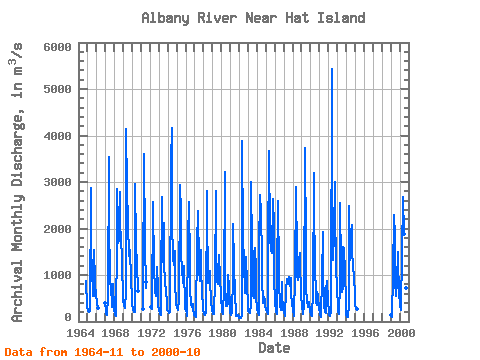
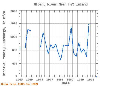
| Year | Jan | Feb | Mar | Apr | May | Jun | Jul | Aug | Sep | Oct | Nov | Dec | Annual | 1964 | 874.00 | 312.00 | 1965 | 226.00 | 205.00 | 197.00 | 228.00 | 2880.00 | 1500.00 | 1140.00 | 557.00 | 544.00 | 1530.00 | 845.00 | 516.00 | 864.00 | 1966 | 474.00 | 392.00 | 299.00 | 393.00 | 1967 | 241.00 | 171.00 | 131.00 | 556.00 | 3540.00 | 2260.00 | 809.00 | 806.00 | 322.00 | 633.00 | 805.00 | 251.00 | 877.08 | 1968 | 187.00 | 145.00 | 127.00 | 1720.00 | 2850.00 | 1680.00 | 2130.00 | 2790.00 | 1740.00 | 1920.00 | 1200.00 | 565.00 | 1421.17 | 1969 | 447.00 | 357.00 | 297.00 | 664.00 | 4130.00 | 2870.00 | 2090.00 | 1410.00 | 1440.00 | 1530.00 | 918.00 | 507.00 | 1388.33 | 1970 | 353.00 | 277.00 | 203.00 | 212.00 | 2950.00 | 1670.00 | 1220.00 | 654.00 | 1971 | 275.00 | 658.00 | 3600.00 | 1670.00 | 713.00 | 853.00 | 1972 | 316.00 | 272.00 | 297.00 | 2580.00 | 1110.00 | 733.00 | 627.00 | 552.00 | 1170.00 | 723.00 | 315.00 | 1973 | 264.00 | 163.00 | 150.00 | 784.00 | 2670.00 | 1270.00 | 2110.00 | 1310.00 | 779.00 | 690.00 | 355.00 | 245.00 | 899.17 | 1974 | 223.00 | 206.00 | 188.00 | 209.00 | 3450.00 | 4170.00 | 2170.00 | 1350.00 | 1220.00 | 1510.00 | 855.00 | 370.00 | 1326.75 | 1975 | 296.00 | 264.00 | 249.00 | 490.00 | 2940.00 | 2360.00 | 1400.00 | 1150.00 | 832.00 | 887.00 | 1190.00 | 264.00 | 1026.83 | 1976 | 231.00 | 179.00 | 128.00 | 1780.00 | 2560.00 | 1220.00 | 697.00 | 374.00 | 302.00 | 386.00 | 270.00 | 143.00 | 689.17 | 1977 | 115.00 | 107.00 | 119.00 | 1640.00 | 2370.00 | 1010.00 | 1800.00 | 866.00 | 1530.00 | 1060.00 | 707.00 | 231.00 | 962.92 | 1978 | 194.00 | 167.00 | 136.00 | 207.00 | 2800.00 | 2380.00 | 831.00 | 922.00 | 1080.00 | 861.00 | 451.00 | 229.00 | 854.83 | 1979 | 182.00 | 151.00 | 154.00 | 920.00 | 2810.00 | 1650.00 | 842.00 | 817.00 | 1430.00 | 1280.00 | 1080.00 | 428.00 | 978.67 | 1980 | 333.00 | 235.00 | 157.00 | 751.00 | 3220.00 | 841.00 | 334.00 | 325.00 | 397.00 | 1010.00 | 739.00 | 307.00 | 720.75 | 1981 | 192.00 | 145.00 | 215.00 | 947.00 | 2090.00 | 1250.00 | 554.00 | 195.00 | 114.00 | 121.00 | 131.00 | 91.50 | 503.79 | 1982 | 81.40 | 77.50 | 76.30 | 145.00 | 3880.00 | 1820.00 | 1280.00 | 609.00 | 935.00 | 1380.00 | 790.00 | 369.00 | 953.60 | 1983 | 235.00 | 198.00 | 184.00 | 360.00 | 3010.00 | 1600.00 | 1460.00 | 567.00 | 502.00 | 1580.00 | 1100.00 | 529.00 | 943.75 | 1984 | 264.00 | 184.00 | 142.00 | 1570.00 | 2730.00 | 2360.00 | 1320.00 | 940.00 | 400.00 | 523.00 | 465.00 | 324.00 | 935.17 | 1985 | 239.00 | 195.00 | 169.00 | 1490.00 | 3660.00 | 1810.00 | 1520.00 | 1850.00 | 1470.00 | 2630.00 | 2050.00 | 932.00 | 1501.25 | 1986 | 417.00 | 224.00 | 152.00 | 974.00 | 2600.00 | 1070.00 | 860.00 | 344.00 | 257.00 | 855.00 | 577.00 | 281.00 | 717.58 | 1987 | 178.00 | 133.00 | 119.00 | 680.00 | 922.00 | 808.00 | 824.00 | 948.00 | 757.00 | 933.00 | 592.00 | 395.00 | 607.42 | 1988 | 220.00 | 136.00 | 113.00 | 995.00 | 2890.00 | 1410.00 | 986.00 | 884.00 | 1300.00 | 1480.00 | 1270.00 | 582.00 | 1022.17 | 1989 | 289.00 | 207.00 | 164.00 | 325.00 | 3740.00 | 1610.00 | 672.00 | 472.00 | 309.00 | 366.00 | 420.00 | 236.00 | 734.17 | 1990 | 140.00 | 111.00 | 134.00 | 622.00 | 3200.00 | 2380.00 | 1320.00 | 416.00 | 363.00 | 625.00 | 555.00 | 259.00 | 843.75 | 1991 | 183.00 | 143.00 | 107.00 | 954.00 | 1920.00 | 1110.00 | 349.00 | 195.00 | 177.00 | 685.00 | 878.00 | 472.00 | 597.75 | 1992 | 181.00 | 131.00 | 119.00 | 223.00 | 5420.00 | 2370.00 | 1330.00 | 1900.00 | 2990.00 | 2360.00 | 1260.00 | 636.00 | 1576.67 | 1993 | 368.00 | 208.00 | 158.00 | 821.00 | 2550.00 | 1170.00 | 632.00 | 720.00 | 1600.00 | 1560.00 | 1040.00 | 464.00 | 940.92 | 1994 | 161.00 | 98.00 | 95.90 | 379.00 | 2490.00 | 1320.00 | 1930.00 | 2080.00 | 1510.00 | 1180.00 | 979.00 | 553.00 | 1064.66 | 1995 | 348.00 | 262.00 | 259.00 | 1999 | 135.00 | 109.00 | 105.00 | 1010.00 | 2300.00 | 1810.00 | 846.00 | 544.00 | 847.00 | 1490.00 | 1330.00 | 620.00 | 928.83 | 2000 | 348.00 | 237.00 | 293.00 | 1450.00 | 2680.00 | 1880.00 | 980.00 | 1350.00 | 712.00 | 817.00 |
|---|
 Return to R-Arctic Net Home Page