|
|
|||||||||||||||||
| Point ID: 4337 | Downloads | Plots | Site Data | Code: 04FC001 |
|
|
|||||||||||||||||
| Download | |
|---|---|
| Site Descriptor Information | Site Time Series Data |
| Link to all available data | |
|
|
| View: | Statistics | Time Series |
| Units: | mm |
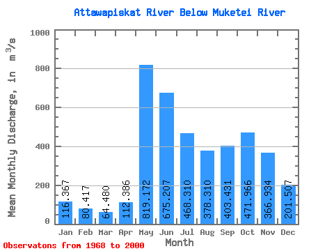
| Statistic | Jan | Feb | Mar | Apr | May | Jun | Jul | Aug | Sep | Oct | Nov | Dec | Annual |
|---|---|---|---|---|---|---|---|---|---|---|---|---|---|
| Mean | 116.37 | 80.42 | 64.48 | 112.39 | 819.17 | 675.21 | 468.31 | 378.31 | 403.43 | 471.97 | 366.93 | 201.51 | 346.22 |
| Standard Deviation | 39.48 | 22.20 | 14.95 | 65.33 | 337.10 | 330.15 | 231.24 | 240.53 | 253.74 | 262.90 | 186.54 | 88.63 | 106.36 |
| Min | 58.80 | 49.00 | 44.50 | 48.00 | 321.00 | 198.00 | 158.00 | 119.00 | 78.70 | 104.00 | 79.10 | 52.70 | 176.39 |
| Max | 198.00 | 122.00 | 104.00 | 326.00 | 1810.00 | 1770.00 | 1230.00 | 1100.00 | 855.00 | 1030.00 | 812.00 | 441.00 | 544.55 |
| Coefficient of Variation | 0.34 | 0.28 | 0.23 | 0.58 | 0.41 | 0.49 | 0.49 | 0.64 | 0.63 | 0.56 | 0.51 | 0.44 | 0.31 |
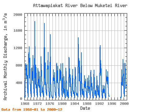
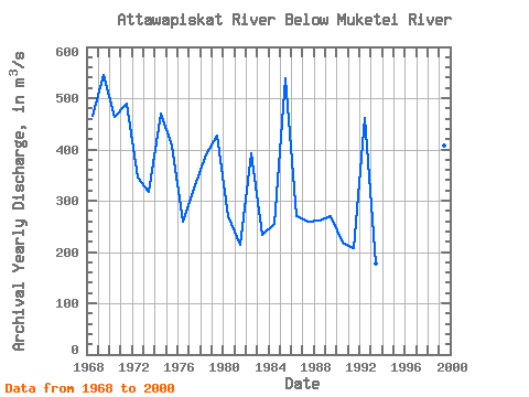
| Year | Jan | Feb | Mar | Apr | May | Jun | Jul | Aug | Sep | Oct | Nov | Dec | Annual | 1968 | 81.80 | 66.60 | 62.90 | 105.00 | 787.00 | 842.00 | 753.00 | 618.00 | 490.00 | 646.00 | 812.00 | 335.00 | 466.61 | 1969 | 198.00 | 121.00 | 75.70 | 64.90 | 1060.00 | 961.00 | 1230.00 | 502.00 | 637.00 | 966.00 | 470.00 | 249.00 | 544.55 | 1970 | 160.00 | 115.00 | 84.00 | 66.30 | 712.00 | 742.00 | 448.00 | 507.00 | 811.00 | 1030.00 | 568.00 | 326.00 | 464.11 | 1971 | 188.00 | 118.00 | 78.40 | 114.00 | 1810.00 | 657.00 | 362.00 | 804.00 | 274.00 | 748.00 | 499.00 | 215.00 | 488.95 | 1972 | 135.00 | 99.90 | 80.20 | 68.30 | 728.00 | 637.00 | 323.00 | 452.00 | 290.00 | 648.00 | 439.00 | 230.00 | 344.20 | 1973 | 124.00 | 89.10 | 76.60 | 92.70 | 1000.00 | 654.00 | 687.00 | 168.00 | 199.00 | 303.00 | 252.00 | 172.00 | 318.12 | 1974 | 118.00 | 87.30 | 70.30 | 65.50 | 646.00 | 1770.00 | 657.00 | 347.00 | 855.00 | 542.00 | 289.00 | 193.00 | 470.01 | 1975 | 149.00 | 122.00 | 104.00 | 101.00 | 645.00 | 792.00 | 713.00 | 1100.00 | 475.00 | 300.00 | 260.00 | 122.00 | 406.92 | 1976 | 77.20 | 60.30 | 54.00 | 231.00 | 1510.00 | 484.00 | 238.00 | 141.00 | 88.80 | 104.00 | 79.10 | 52.70 | 260.01 | 1977 | 58.80 | 49.70 | 44.50 | 326.00 | 696.00 | 450.00 | 508.00 | 374.00 | 634.00 | 390.00 | 216.00 | 143.00 | 324.17 | 1978 | 104.00 | 80.10 | 64.00 | 55.50 | 815.00 | 849.00 | 397.00 | 576.00 | 775.00 | 447.00 | 339.00 | 191.00 | 391.05 | 1979 | 114.00 | 84.20 | 69.00 | 101.00 | 712.00 | 664.00 | 447.00 | 517.00 | 835.00 | 671.00 | 633.00 | 288.00 | 427.93 | 1980 | 147.00 | 92.90 | 73.40 | 190.00 | 839.00 | 332.00 | 199.00 | 146.00 | 189.00 | 544.00 | 346.00 | 146.00 | 270.36 | 1981 | 85.40 | 64.00 | 58.10 | 57.10 | 738.00 | 578.00 | 305.00 | 119.00 | 78.70 | 118.00 | 234.00 | 134.00 | 214.11 | 1982 | 87.20 | 59.20 | 45.40 | 51.90 | 984.00 | 949.00 | 499.00 | 308.00 | 503.00 | 584.00 | 429.00 | 200.00 | 391.64 | 1983 | 116.00 | 82.40 | 66.10 | 65.60 | 321.00 | 429.00 | 704.00 | 292.00 | 144.00 | 211.00 | 211.00 | 160.00 | 233.51 | 1984 | 114.00 | 80.10 | 55.40 | 203.00 | 754.00 | 691.00 | 400.00 | 219.00 | 114.00 | 131.00 | 154.00 | 137.00 | 254.38 | 1985 | 114.00 | 89.00 | 69.70 | 87.30 | 1440.00 | 1130.00 | 786.00 | 439.00 | 553.00 | 899.00 | 600.00 | 263.00 | 539.17 | 1986 | 144.00 | 88.40 | 65.60 | 149.00 | 1090.00 | 487.00 | 271.00 | 165.00 | 116.00 | 236.00 | 257.00 | 158.00 | 268.92 | 1987 | 97.10 | 69.10 | 61.40 | 180.00 | 564.00 | 325.00 | 279.00 | 356.00 | 486.00 | 305.00 | 239.00 | 148.00 | 259.13 | 1988 | 91.70 | 57.90 | 46.10 | 135.00 | 504.00 | 357.00 | 253.00 | 172.00 | 340.00 | 562.00 | 355.00 | 250.00 | 260.31 | 1989 | 149.00 | 93.90 | 62.30 | 48.00 | 597.00 | 684.00 | 376.00 | 223.00 | 271.00 | 382.00 | 242.00 | 120.00 | 270.68 | 1990 | 78.60 | 55.50 | 47.80 | 54.80 | 499.00 | 691.00 | 356.00 | 156.00 | 101.00 | 159.00 | 229.00 | 180.00 | 217.31 | 1991 | 101.00 | 67.50 | 51.60 | 111.00 | 547.00 | 349.00 | 225.00 | 138.00 | 110.00 | 344.00 | 287.00 | 151.00 | 206.84 | 1992 | 87.70 | 64.90 | 58.20 | 65.70 | 1180.00 | 1260.00 | 567.00 | 833.00 | 608.00 | 424.00 | 246.00 | 142.00 | 461.38 | 1993 | 75.00 | 52.90 | 48.80 | 150.00 | 340.00 | 198.00 | 158.00 | 174.00 | 327.00 | 278.00 | 202.00 | 113.00 | 176.39 | 1994 | 70.50 | 52.50 | 45.50 | 50.60 | 699.00 | 421.00 | 492.00 | 518.00 | 366.00 | 421.00 | 656.00 | 401.00 | 349.43 | 1995 | 178.00 | 107.00 | 87.90 | 1999 | 60.00 | 49.00 | 45.40 | 109.00 | 701.00 | 350.00 | 351.00 | 331.00 | 760.00 | 938.00 | 758.00 | 441.00 | 407.78 | 2000 | 187.00 | 93.10 | 82.10 | 160.00 | 838.00 | 848.00 | 597.00 | 276.00 | 269.00 | 356.00 | 340.00 | 183.00 | 352.43 |
|---|
 Return to R-Arctic Net Home Page