|
|
|||||||||||||||||
| Point ID: 382 | Downloads | Plots | Site Data | Code: 05CD004 |
|
|
|||||||||||||||||
| Download | |
|---|---|
| Site Descriptor Information | Site Time Series Data |
| Link to all available data | |
|

|
| View: | Statistics | Time Series |
| Units: | mm |
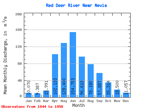
| Statistic | Jan | Feb | Mar | Apr | May | Jun | Jul | Aug | Sep | Oct | Nov | Dec | Annual |
|---|---|---|---|---|---|---|---|---|---|---|---|---|---|
| Mean | 10.07 | 9.39 | 15.99 | 102.13 | 128.40 | 154.75 | 96.61 | 78.18 | 57.89 | 35.31 | 18.50 | 11.06 | 56.60 |
| Standard Deviation | 3.79 | 2.46 | 9.17 | 69.83 | 121.28 | 82.64 | 31.78 | 65.72 | 51.94 | 18.99 | 5.60 | 4.89 | 26.43 |
| Min | 4.55 | 5.73 | 5.83 | 30.80 | 34.90 | 39.40 | 37.40 | 30.00 | 17.80 | 15.80 | 11.60 | 4.56 | 23.07 |
| Max | 14.70 | 11.80 | 40.20 | 268.00 | 516.00 | 311.00 | 148.00 | 289.00 | 213.00 | 83.30 | 28.60 | 18.40 | 95.83 |
| Coefficient of Variation | 0.38 | 0.26 | 0.57 | 0.68 | 0.94 | 0.53 | 0.33 | 0.84 | 0.90 | 0.54 | 0.30 | 0.44 | 0.47 |
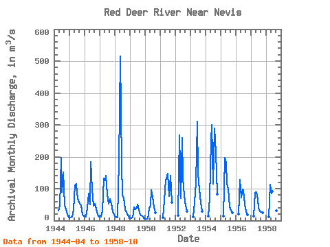
| Year | Jan | Feb | Mar | Apr | May | Jun | Jul | Aug | Sep | Oct | Nov | Dec | Annual | 1944 | 30.80 | 46.90 | 197.00 | 89.80 | 151.00 | 48.00 | 34.50 | 17.90 | 10.00 | 1945 | 8.45 | 8.77 | 12.60 | 32.40 | 110.00 | 115.00 | 85.30 | 62.00 | 52.10 | 49.40 | 19.20 | 14.20 | 47.45 | 1946 | 13.60 | 11.80 | 40.20 | 84.60 | 50.00 | 183.00 | 97.70 | 47.30 | 53.50 | 34.80 | 17.50 | 11.60 | 53.80 | 1947 | 11.00 | 10.90 | 31.10 | 133.00 | 125.00 | 141.00 | 82.80 | 52.50 | 67.50 | 52.20 | 28.60 | 18.40 | 62.83 | 1948 | 14.70 | 11.60 | 10.60 | 187.00 | 516.00 | 176.00 | 80.70 | 70.60 | 35.10 | 23.90 | 16.20 | 7.58 | 95.83 | 1949 | 8.12 | 7.52 | 10.50 | 42.80 | 34.90 | 39.40 | 49.50 | 34.40 | 17.80 | 15.80 | 11.60 | 4.56 | 23.07 | 1950 | 4.55 | 5.73 | 5.83 | 36.70 | 48.00 | 94.70 | 74.60 | 42.20 | 23.70 | 1951 | 8.94 | 63.80 | 129.00 | 131.00 | 148.00 | 76.40 | 140.00 | 57.60 | 1952 | 17.10 | 268.00 | 70.10 | 260.00 | 135.00 | 78.90 | 45.40 | 29.00 | 1953 | 12.90 | 57.30 | 120.00 | 311.00 | 147.00 | 96.80 | 54.60 | 28.30 | 1954 | 13.90 | 70.30 | 250.00 | 301.00 | 116.00 | 289.00 | 213.00 | 83.30 | 1955 | 14.80 | 197.00 | 179.00 | 116.00 | 99.00 | 43.10 | 31.00 | 23.90 | 1956 | 19.80 | 129.00 | 72.20 | 97.50 | 93.40 | 50.00 | 28.10 | 17.40 | 1957 | 14.10 | 87.30 | 90.20 | 67.30 | 37.40 | 30.00 | 26.30 | 24.20 | 1958 | 11.50 | 112.00 | 84.70 | 91.40 | 113.00 | 48.50 | 32.20 | 20.10 |
|---|
 Return to R-Arctic Net Home Page