|
|
|||||||||||||||||
| Point ID: 3687 | Downloads | Plots | Site Data | Code: 10SB001 |
|
|
|||||||||||||||||
| Download | |
|---|---|
| Site Descriptor Information | Site Time Series Data |
| Link to all available data | |
|
|
| View: | Statistics | Time Series |
| Units: | mm |
| Statistic | Jan | Feb | Mar | Apr | May | Jun | Jul | Aug | Sep | Oct | Nov | Dec | Annual |
|---|---|---|---|---|---|---|---|---|---|---|---|---|---|
| Mean | 0.00 | 0.00 | 0.00 | 0.00 | 1.41 | 522.34 | 586.28 | 224.37 | 165.24 | 36.13 | 4.37 | 0.47 | 120.32 |
| Standard Deviation | 0.00 | 0.00 | 0.00 | 0.00 | 3.35 | 281.38 | 393.52 | 132.71 | 76.39 | 22.95 | 7.61 | 1.62 | 29.54 |
| Min | 0.00 | 0.00 | 0.00 | 0.00 | 0.00 | 0.97 | 149.00 | 61.90 | 34.90 | 0.00 | 0.00 | 0.00 | 62.99 |
| Max | 0.00 | 0.00 | 0.00 | 0.00 | 13.60 | 935.00 | 1780.00 | 572.00 | 331.00 | 98.10 | 32.70 | 7.02 | 160.88 |
| Coefficient of Variation | 2.37 | 0.54 | 0.67 | 0.59 | 0.46 | 0.64 | 1.74 | 3.47 | 0.25 |
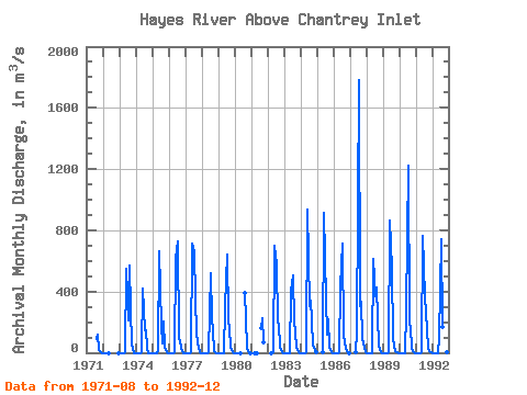
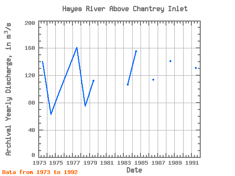
| Year | Jan | Feb | Mar | Apr | May | Jun | Jul | Aug | Sep | Oct | Nov | Dec | Annual | 1971 | 88.80 | 117.00 | 20.30 | 1.09 | 0.00 | 1972 | 0.00 | 0.00 | 0.00 | 0.00 | 0.00 | 0.00 | 1973 | 0.00 | 0.00 | 0.00 | 0.00 | 5.32 | 550.00 | 210.00 | 572.00 | 284.00 | 62.50 | 0.00 | 0.00 | 140.32 | 1974 | 0.00 | 0.00 | 0.00 | 0.00 | 6.94 | 417.00 | 149.00 | 148.00 | 34.90 | 0.00 | 0.00 | 0.00 | 62.99 | 1975 | 0.00 | 0.00 | 0.00 | 0.00 | 13.60 | 665.00 | 181.00 | 61.90 | 206.00 | 41.10 | 1.24 | 0.00 | 97.49 | 1976 | 0.00 | 0.00 | 0.00 | 0.00 | 0.35 | 623.00 | 725.00 | 86.20 | 79.40 | 22.90 | 0.00 | 0.00 | 128.07 | 1977 | 0.00 | 0.00 | 0.00 | 0.00 | 0.29 | 711.00 | 658.00 | 365.00 | 123.00 | 66.70 | 6.56 | 0.00 | 160.88 | 1978 | 0.00 | 0.00 | 0.00 | 0.00 | 0.00 | 0.97 | 521.00 | 218.00 | 146.00 | 11.30 | 0.00 | 0.00 | 74.77 | 1979 | 0.00 | 0.00 | 0.00 | 0.00 | 0.00 | 298.00 | 639.00 | 214.00 | 163.00 | 30.20 | 1.36 | 0.00 | 112.13 | 1980 | 0.00 | 0.00 | 0.00 | 0.00 | 0.00 | 393.00 | 225.00 | 22.30 | 0.27 | 0.00 | 1981 | 0.00 | 0.00 | 0.00 | 164.00 | 223.00 | 65.10 | 1982 | 0.00 | 0.00 | 0.03 | 696.00 | 574.00 | 197.00 | 187.00 | 41.10 | 2.61 | 0.00 | 1983 | 0.00 | 0.00 | 0.00 | 0.00 | 0.00 | 402.00 | 508.00 | 195.00 | 139.00 | 34.40 | 3.25 | 0.00 | 106.80 | 1984 | 0.00 | 0.00 | 0.00 | 0.00 | 0.02 | 935.00 | 306.00 | 343.00 | 212.00 | 46.90 | 16.30 | 2.79 | 155.17 | 1985 | 1.80 | 912.00 | 349.00 | 120.00 | 222.00 | 42.40 | 5.76 | 0.00 | 1986 | 0.00 | 0.00 | 0.00 | 0.00 | 0.11 | 437.00 | 713.00 | 106.00 | 76.20 | 25.00 | 3.69 | 0.00 | 113.42 | 1987 | 0.00 | 141.00 | 1780.00 | 304.00 | 331.00 | 98.10 | 32.70 | 7.02 | 1988 | 0.00 | 0.00 | 0.00 | 0.00 | 0.00 | 612.00 | 371.00 | 424.00 | 235.00 | 48.90 | 3.23 | 0.00 | 141.18 | 1989 | 0.00 | 0.00 | 0.00 | 0.00 | 1.09 | 867.00 | 545.00 | 91.80 | 48.80 | 13.00 | 1.30 | 0.00 | 130.67 | 1990 | 0.00 | 0.00 | 0.00 | 0.00 | 0.00 | 278.00 | 1220.00 | 192.00 | 166.00 | 24.90 | 2.15 | 0.00 | 156.92 | 1991 | 0.00 | 0.00 | 0.00 | 0.00 | 0.11 | 762.00 | 365.00 | 259.00 | 155.00 | 24.00 | 3.75 | 0.00 | 130.74 | 1992 | 0.00 | 0.00 | 0.00 | 0.00 | 0.00 | 95.20 | 739.00 | 169.00 | 96.80 | 17.60 | 2.19 | 0.00 | 93.32 |
|---|
 Return to R-Arctic Net Home Page
