|
|
|||||||||||||||||
| Point ID: 3686 | Downloads | Plots | Site Data | Code: 10RC001 |
|
|
|||||||||||||||||
| Download | |
|---|---|
| Site Descriptor Information | Site Time Series Data |
| Link to all available data | |
|
|
| View: | Statistics | Time Series |
| Units: | mm |
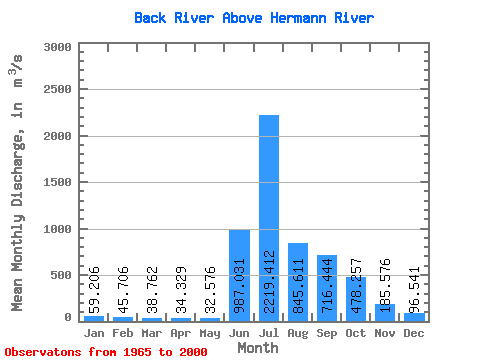
| Statistic | Jan | Feb | Mar | Apr | May | Jun | Jul | Aug | Sep | Oct | Nov | Dec | Annual |
|---|---|---|---|---|---|---|---|---|---|---|---|---|---|
| Mean | 59.21 | 45.71 | 38.76 | 34.33 | 32.58 | 987.03 | 2219.41 | 845.61 | 716.44 | 478.26 | 185.58 | 96.54 | 480.79 |
| Standard Deviation | 17.96 | 12.37 | 9.38 | 8.04 | 7.66 | 622.16 | 782.83 | 229.25 | 327.39 | 236.57 | 79.50 | 34.19 | 86.61 |
| Min | 28.50 | 23.30 | 21.70 | 21.30 | 17.10 | 58.90 | 1000.00 | 409.00 | 370.00 | 193.00 | 84.80 | 46.80 | 355.88 |
| Max | 101.00 | 73.70 | 60.40 | 55.50 | 53.00 | 2090.00 | 4420.00 | 1490.00 | 1790.00 | 987.00 | 347.00 | 166.00 | 727.18 |
| Coefficient of Variation | 0.30 | 0.27 | 0.24 | 0.23 | 0.23 | 0.63 | 0.35 | 0.27 | 0.46 | 0.49 | 0.43 | 0.35 | 0.18 |
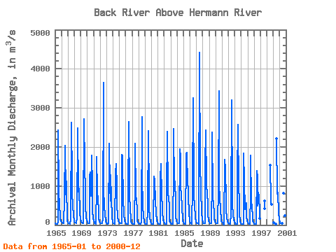
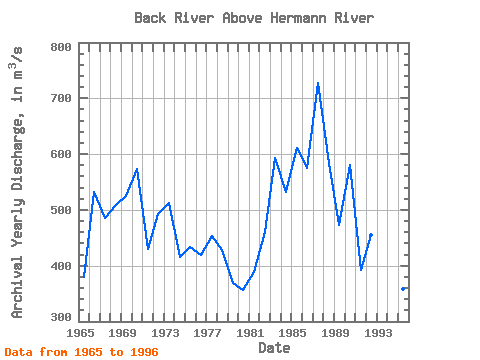
| Year | Jan | Feb | Mar | Apr | May | Jun | Jul | Aug | Sep | Oct | Nov | Dec | Annual | 1965 | 43.30 | 34.60 | 32.70 | 31.70 | 31.00 | 75.30 | 2430.00 | 889.00 | 467.00 | 279.00 | 149.00 | 103.00 | 380.47 | 1966 | 76.30 | 60.30 | 48.80 | 41.00 | 37.00 | 660.00 | 2040.00 | 772.00 | 1400.00 | 858.00 | 270.00 | 124.00 | 532.28 | 1967 | 67.60 | 46.50 | 39.10 | 36.00 | 34.40 | 130.00 | 2620.00 | 1180.00 | 794.00 | 517.00 | 224.00 | 127.00 | 484.63 | 1968 | 82.70 | 66.80 | 59.10 | 55.50 | 53.00 | 198.00 | 2480.00 | 857.00 | 850.00 | 946.00 | 306.00 | 156.00 | 509.18 | 1969 | 101.00 | 73.70 | 60.40 | 53.60 | 49.20 | 58.90 | 2720.00 | 1490.00 | 908.00 | 459.00 | 203.00 | 117.00 | 524.48 | 1970 | 76.60 | 55.40 | 43.80 | 38.80 | 36.30 | 1250.00 | 1360.00 | 739.00 | 1790.00 | 987.00 | 347.00 | 164.00 | 573.99 | 1971 | 101.00 | 71.70 | 52.80 | 40.20 | 32.10 | 995.00 | 1750.00 | 859.00 | 630.00 | 399.00 | 144.00 | 88.70 | 430.29 | 1972 | 64.40 | 52.00 | 44.40 | 39.60 | 36.10 | 150.00 | 3650.00 | 916.00 | 479.00 | 263.00 | 132.00 | 79.20 | 492.14 | 1973 | 51.80 | 36.60 | 28.80 | 25.30 | 37.90 | 2090.00 | 1000.00 | 615.00 | 1290.00 | 685.00 | 195.00 | 94.80 | 512.52 | 1974 | 61.90 | 47.70 | 40.10 | 35.80 | 33.30 | 1320.00 | 1560.00 | 983.00 | 528.00 | 210.00 | 103.00 | 69.60 | 416.03 | 1975 | 54.10 | 46.10 | 41.50 | 38.60 | 37.30 | 1810.00 | 1770.00 | 549.00 | 414.00 | 251.00 | 117.00 | 67.80 | 433.03 | 1976 | 45.80 | 37.00 | 32.80 | 30.30 | 29.20 | 704.00 | 2640.00 | 798.00 | 370.00 | 193.00 | 86.10 | 53.50 | 418.31 | 1977 | 38.00 | 30.50 | 27.70 | 26.50 | 25.80 | 1220.00 | 2080.00 | 791.00 | 600.00 | 417.00 | 121.00 | 67.60 | 453.76 | 1978 | 47.70 | 40.40 | 36.90 | 34.90 | 34.10 | 64.80 | 2770.00 | 1230.00 | 493.00 | 224.00 | 100.00 | 59.40 | 427.93 | 1979 | 41.80 | 34.30 | 30.30 | 28.00 | 26.00 | 359.00 | 2410.00 | 727.00 | 445.00 | 193.00 | 87.70 | 54.00 | 369.68 | 1980 | 39.30 | 32.30 | 28.40 | 26.20 | 24.60 | 1240.00 | 1160.00 | 592.00 | 639.00 | 303.00 | 118.00 | 67.70 | 355.88 | 1981 | 47.10 | 37.50 | 32.90 | 29.80 | 27.80 | 1200.00 | 1560.00 | 753.00 | 454.00 | 322.00 | 130.00 | 72.20 | 388.86 | 1982 | 50.20 | 40.50 | 35.30 | 32.20 | 30.30 | 779.00 | 2390.00 | 816.00 | 686.00 | 472.00 | 125.00 | 70.80 | 460.61 | 1983 | 48.80 | 39.10 | 34.00 | 31.90 | 31.00 | 1420.00 | 2470.00 | 996.00 | 1120.00 | 609.00 | 215.00 | 107.00 | 593.48 | 1984 | 65.00 | 47.90 | 40.10 | 37.20 | 36.70 | 1950.00 | 1740.00 | 897.00 | 851.00 | 401.00 | 201.00 | 110.00 | 531.41 | 1985 | 69.10 | 49.40 | 36.90 | 29.80 | 26.90 | 1830.00 | 1860.00 | 1030.00 | 1220.00 | 761.00 | 272.00 | 141.00 | 610.51 | 1986 | 73.30 | 49.30 | 43.90 | 34.00 | 28.50 | 974.00 | 3250.00 | 926.00 | 748.00 | 511.00 | 194.00 | 79.50 | 575.96 | 1987 | 44.80 | 39.30 | 43.30 | 38.20 | 32.60 | 292.00 | 4420.00 | 1310.00 | 1160.00 | 888.00 | 318.00 | 140.00 | 727.18 | 1988 | 68.30 | 52.60 | 49.70 | 44.30 | 38.80 | 1500.00 | 2420.00 | 1090.00 | 739.00 | 623.00 | 275.00 | 112.00 | 584.39 | 1989 | 67.20 | 50.30 | 42.30 | 38.80 | 37.50 | 1170.00 | 2370.00 | 785.00 | 475.00 | 370.00 | 178.00 | 86.10 | 472.52 | 1990 | 58.80 | 49.70 | 44.70 | 41.50 | 39.40 | 935.00 | 3440.00 | 1000.00 | 712.00 | 388.00 | 158.00 | 93.10 | 580.02 | 1991 | 81.10 | 60.40 | 39.90 | 24.60 | 17.10 | 1670.00 | 1450.00 | 627.00 | 374.00 | 213.00 | 84.80 | 57.70 | 391.63 | 1992 | 45.80 | 39.40 | 33.20 | 26.80 | 20.90 | 287.00 | 3200.00 | 824.00 | 515.00 | 261.00 | 128.00 | 71.70 | 454.40 | 1993 | 42.10 | 28.30 | 24.20 | 24.50 | 27.30 | 1250.00 | 2570.00 | 964.00 | 629.00 | 271.00 | 101.00 | 46.80 | 498.18 | 1994 | 28.50 | 23.30 | 21.70 | 21.50 | 32.80 | 1830.00 | 1130.00 | 409.00 | 470.00 | 564.00 | 227.00 | 107.00 | 405.40 | 1995 | 64.40 | 47.40 | 37.40 | 30.40 | 24.90 | 793.00 | 1780.00 | 656.00 | 418.00 | 259.00 | 123.00 | 61.20 | 357.89 | 1996 | 33.40 | 26.70 | 23.60 | 21.30 | 19.40 | 1380.00 | 1210.00 | 486.00 | 830.00 | 744.00 | 320.00 | 166.00 | 438.37 | 1997 | 626.00 | 421.00 | 1998 | 1540.00 | 620.00 | 531.00 | 528.00 | 1999 | 60.70 | 49.90 | 40.40 | 34.60 | 2220.00 | 832.00 | 745.00 | 838.00 | 315.00 | 142.00 | 2000 | 72.60 | 46.30 | 37.30 | 38.00 | 43.80 | 808.00 | 597.00 | 532.00 | 242.00 | 125.00 |
|---|
 Return to R-Arctic Net Home Page